|
SEDIMENTOLOGICAL AND
CHEMICAL STUDIES IN SEDIMENTS FROM PAPALOAPAN RIVER MEXICO
Trabajo
recibido el 19 de junio de 1985 y aceptado para su publicación el 24 de
octubre de 1985.
LETICIA ROSALES HOZ, ARTURO CARRANZA EDWARDS y UBALDINA ALVAREZ RIVERA
Universidad Nacional Autónoma de México, Instituto
de Ciencias del Mar y Limnología, UNAM. Contribución 466
del Instituto de Ciencias del Mar y Limnología, UNAM.
Se estudiaron
sedimentos del río Papaloapan desde un punto de vista químico
y sedimentológico; se determinó el tamaño gráfico
promedio, la desviación estandar, el grado de asimetría
y la curtosis de los sedimentos, asimismo se analizó el contenido
de materia orgánica, los carbonatos y los metales traza presentes
en los sedimentos del río Papaloapan en dos diferentes épocas
del año. Simultáneamente se midió la salinidad,
el oxígeno, pH y temperatura en la columna de agua. Los parámetros
hidrológicos observados, así como el tipo de sedimento
encontrado reflejan la influencia de las rocas que constituyen la cuenca.
La concentración superficial de metales fue más alta en
Mayo de 81, disminuyendo la concentración de níquel, cromo
y zinc en Dic. del 81; estos cambios en la concentración de metales
son atribuidos a descargas industriales. Los parámetros químicos
y sedimentológicos en los núcleos estudiados muestran
una baja concentración de metales con patrones de distribución
altamente homogéneos; las características sedimentológicas
de los núcleos dependen de la ubicación de los puntos
de muestreo y de la dinámica presente en estos puntos.
Sediments
of Papaloapan river were studied from both sedimentological and chemical
points of view. Mean graphic size, standard deviation, skewness, kurtosis,
organic matter, carbonates and trace metals were measured in sediments
from Papaloapan river at two different times of the year. Salinity,
oxygen, pH and temperature were measured in the water columnn at the
same time. The river hydrological parameters and type of sediment reflect
the influence of the main rock outcrops that form the basin. Surface
metal concentration was higher during May 81 with a decrease in nickel,
chromium and zinc concentration during Dec. 81; this changes in metal
concentation are attributed to industry discharges. The sedimentological
and chemical parameters of the cores studied generally show low metal
concentration with a highly homogeneous distribution pattern, the sedimentological
characteristics of the cores are a function of the location of the sampling
points and the dynamic present at that point. In order to evaluate trace metal concentrations in sediments from Papaloapan river and their relation to lithological units, hydrological effects, geological feature and industrial influence Papaploapan river water column and sediments were studied at different river locations. Total metal concentration in sediments was measured as a function of grain size, organic matter content and carbonate content of the sediment; textural parameters were determined in order to observe the river sedimentological characteristics. Whenever possible core samples were taken to allow the study of the industrial influence on metal concentrations. The correlation of metal concentration with the textural parameters of the sediment column was also studied when core samples were obtainable. STUDY AREAPapaloapan river basin covers an approximate area of 57,756 km² and goes through Oaxaca, Puebla and Veracruz states. It is located between 17-19° north latitude and 95°–97°40' west longitude (Fig. 1). Several rivers contribute to Papaloapan river basin, the main ones are: 1) Tonto river that is born in the Mazatec mountains, near temezcal town; the Miguel Aleman dam was build with Tonto rivers water, it has 8000 millions m³ capacity and is used to produce hydroelectric energy. 2) Santo Domingo river which is formed by several rivers, the main ones are: Hondo river, Jiquila river, Grande river and Valle Nacional river. After the junction of Valle Nacional river and Santo Domingo river, the Papaloapan receives its name, around 20 km from this point of junction Papaloapan river receives through its right side waters coming from Tonto river. 3) Obipo river with a basin of around 1065 km² and an average drainage of 642 millions m³ joins Papaloapan river near Cosamaloapan town. 4) Playa San Vicente river with a basin of 57000 km² and average drainage of 6638 millions m³ . 5) San Juan river 6) Tecomate river The last two rivers with a basin of 9600 km² and an average drainage of 7725 millions m³ , San Juan river joins Papaloapan river neat Tlacotalpan town and Tecomate river waters reach Tehuapa lagoon, which is communicated with Papaloapan river. 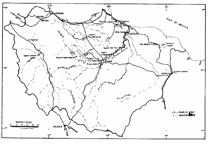 Fig. 1. Sampling point location in the study area. Papaloapan river reaches Alvarado lagoon and from there together with Blanco river waters goes to the Gulf of Mexico. There are two sections to consider in the river: a high basin that is formed by teh different rivers up to the joining point between Papaloapan river and Tonto river, and the lower basin, from this point of junction until the river reaches the sea through Alvarado lagoon; the lower basin corresponds to the development of the coastal plain with heights lower to 10 m above sea level. The temperature of the area is a function of height above sea level, with the lower temperatures (10°C) located at heights of 2500 mts and the higher temperature (43ºC) located in the mouth of the river at Alvarado fishing port. According to Secretaría de Recursos Hidráulicos (1975) the anual precipitation in the higher basin (Miguel Aleman dam) goes from 600 to 5000 mm and in the lower basin the averge precipitation in 1500 mm with an average monthly distribution of 130 mm; the lower values are observed from December to May and the higher values from June to September; from July to October there are tropical storms that highly affec the area and area an important contribution to the precipitation in the lower basin. Along Papaloapan river several industries are found (Fig. 1). They are mainly sugar refinery industries, but there are also some chemical industries (Proquivemex and Altos Hornos). MATERIAL AND METHODSEleven samples of sediments distributed along the river basin were collected during May 81 and Decemer 81, the location of the sampling stations in shown in figure 1. Sediment samples were obtained by the Phleger core sampler or by hand, the cores (60 cim long by 4.7 cm intemal diameter) were kept in a vertical position surrounded by ice and refrigerated as soon as possible. Core samples were only taken in the river lower section (sampling points 1 to 5) since the rocky nature of the bottom in the river high section prevented core collection. In the rocky zone only surface sediments samples were taken, these were kept in plastic bags at 4°C. Conductivity, oxygen, temperature and pH data were taken in situ at the sampling time, the values are shown in table 1. COnductivity and temperature were measured in a Kahlsico apparatus model R55-3, oxygen was measured in an oxymeter YSI model 57 and pH with a potentiometer Corning Model 30. The core samples were examined by X-Ray (58 Kv and 16 mas) those with a homogeneous distribution were divided into four 15 cm portions, the cores with important stratigraphic changes were separated accordingly. Representative portions of the sediment were dried at 105°C and stored in plastic bags prior to sedimentological and chemical analysis. Sedimentological analyses were realized by Folk's method (1974) after organic matter destruction with H2O2. The concentration of organic matter was determined by oxidation with potassium dichromate and titration with ferrous sulfate (Gaudette, 1974). The amount of carbonate was determined measuring the CO2 volume produced by the reaction of the sample with 50% hydrochloric acid. Total metal concentration was determined by sample treatment with nitric, perchloric, fluorhidric, and hydrochloric acids (Bruland, 1974; Jones, 1979). Metal concentration was measure in an atomic absorption spectrophotometer Varian models 1200 and 475. RESULTS AND DISCUSSION
HYDROLOGICAL PARAMETERSThe hydrological parameters obtained in the water column of Papaloapan river at the two sampling trips carried out are shown in Table 1. The salinity observed through all the system generally shows low values; sampling point 1 has higher values than all other sampling points because it is located near the river conection with the sea. The values obtained at this point are a function of flux-ebb conditions and change with time as shown by the analysis of the salinity data obtained at the same point in December 1980 and May 1981 (Table 1). Aside from this, sampling point 11 shows higher salinity values than other points along the river, this point corresponds to Salado river (salty) and the salinity observed is possibly produced by the presence of hard waters usually found in zones mainly formed by carbonate rocks. The high content of magnesium in the sediments at this sampling point (11) further supports this view. 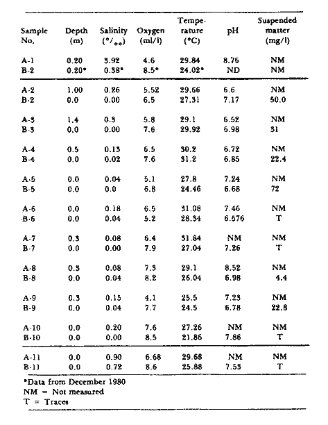 TABLE 1 SALINITY (%o) OXYGEN (ml/l) TEMPERATURE (ºC). PH AND SUSPENDED MATTER (mg/l) IN THE WATER COLUMN AT SAMPLING STATIONS IN PAPALOAPAN RIVER. A; MAY 81. B: DEC. 81). Oxygen concentration is usually lower during the first sampling trip (May 1981) that belongs to the dry season, this can be related to the high amount of organic matter introduced to the river by the sugar refineries industries since the recollection and refining of the plant takes place from Jan. to Jul.; sampling points 10 and 11 show higher oxygen concentration in both sampling trips. These sampling points belong to small currents with very low depth which permit a good exchange between the air-water system. Temperature data are higher in the first sampling trip, usually the higher values are observed in the lower basin; the lowest temperature values was detected at station 9. Stations 10 and 11 have high temperature values even though they are located in the high basin, this is due to the small depth of the water column at these points which permits homogeneous heating by the sun. Values of pH from 6.6. to 8.7 are observed through the system with lower values in the station located in the lower basin; suspended matter concentration (Table 1) vary from traces values to 72 mg/1. The highest value corresponds to sampling point 5 located near the discharges from Proquivemex; there are several points with very low suspended matter loadings (6, 7, 10, 11) that are located in areas without a strong industry influence. SEDIMENTOLOGICAL PARAMETERSDuring the first sampling trips the finest superficial sediments corresponded to samples A-1, A-5, A-9, A- 10, these samples are not well classified and their high mean graphic size reflect low energy deposition conditions, this even when they are being transported the fluvial system; two of this points belong to the high basin (9, 10), one to the lower part of the high basin (5) and the last one to the low basin near the river conection with the sea (1). Sampling point 1 corresponds to a fine sediment deposition zone produced by the discharge of Papaloapan river into Alvarado lagoon. The sediments are finer at the surface of the core; which could be produced by natural washing of the fine sediment material after its deposition. Sampling point 5 changes the mean graphic size of the sediment from clays to fine sands from one trip to the other. This could be related to the location of this point near the discharge point of Proquivemex and the sugar refinery of Tres Valles. Sampling point 9 and 10 show a variation of mean graphic size from one trip to the other that can be related to seasonal changes. All other sampling points show mean graphic size in the range of fine sands to clays, except sampling point 4 that has sediments with mean graphic size belonging to medium size sands in both sampling trips realized. The current at this point is high which explains the ø values found. 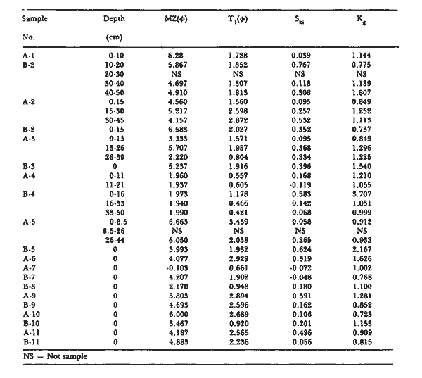 TABLE 2 TEXTURAL PARAMETERS METAL CONCENTRATION IN SURFACE SEDIMENTSGiven the large number of affluents that form Papaloapan river high basin the sampling stations are located in different sections of the river so that an evaluation of the influence of the different river affluents to the main current can be made. However in figure 2 the organic matter (%), carbonates (%) and metal concentration (ppm dry weight basin) in surface sediments are represented as a function of the distance to the river communication with the sea in the two sampling trips realized. This permits to observe more clearly the concentration changes from one trip to the other. Organic matter concentration in the sediment vary from 0.03% to 2.06%. The highest values correspond to the high basin in the first sampling trip, mainly sampling point 5 and 9 which are located near industry installations. (Fig. 1). 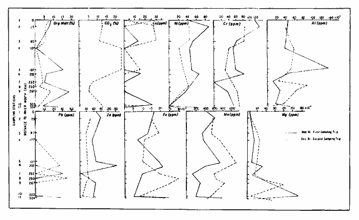 Fig. 2. Organic matter (%), carbonates (%) and metal concentration (ppm dry weight basis) in surface sediment samples along Papaloapan river. Carbonate concentration (4.51-24.76%) shows that sampling points 4 and 5 have higher carbonate concentration than all other sampling points, Santo Domingo river and Tonto river mainly go through a calcareous region. (SPP, 1981) and join Papaloapan river near sampling point 5 which corresponds to the start of the coastal plain; therefore the sediments deposited at these points (4 and 5) reflect the influence of the rocks that form the hills surrounding the NW part of the high basin. The drainage area that affects sampling points 7, 8 and 9 is small, which accounts for the lower carbonate concentration at these points. However the drainage area of Salado river and Omotepec river is larger, which produces a higer carbonate concentration in sampling points 10 and 11. Results for the trace element analysis in surface sediments are shown in figure 2 as a function of the distance to the river mouth; concentrations are reported in mg/kg dry weight basis and for copper they range from 13.66 to 32.16, nickel 23.2 to 87.33 chromium 30.6 to 124.32, lead, none to 38.5, zinc 6.58 to 88.8, cobalt none to 22.75, manganese 166.7 to 1182.6, iron 0.8 to 3.0%, alminium 1.3 to 13.8% and magnesium 0.39 to 17.4%. Nickel, chromium and zinc concentration are higher in the first sampling trip, this agrees with the results found in Alvarado lagoon (Rosales et al., 1986), at the same time of the year and a attributed to industry discharges. It was not possible to correlate the observed values of metal concentration with the type of sediment present. However o higher adsorption of trace metals in expected in fine sediments if the sediment is near pollution sources; According to mean graphic size values the sampling points 1 and 5 could accept higher metal adsorption. Sampling point 1 shows higher values than all other points but that is not the case for point 5. Sampling point 7 is highly asymetric and tends to present coarse values and none Ni, Cu, Cr and Co were detected in this sample. This was expected given that metal adsorption in coarse sediments is very low. The sample with the highest mean graphic size value (5), has the highest aluminium concentration and the sample with the lowest mean graphic size value (7) ha the lowest aluminium concentration. This suggests that up to a point aluminium concentration is relate to the presence of clay minerals. Very few correlations were found between the different metals, organic matter, mean graphic size and carbonate concentration in surface sediment samples (Table 3). A good correlation was found for magnesium and iron which suggests that these metals are present as ferromagnesium minerals. High concentration of carbonate affect the iron concentration in the sediments as is indicated by the negative correlation between these components (CO3 and Fe) (Förstner, 1981). Carbonate presence appears to have a diluting factor on the chromium concentration. The fact that so few correlations were found among the different parameters studied is attributed to the large magnitude of the Papaloapan basin, besides the fact that fluvial sediment samples are highly variable from a geologic point of view. SEDIMENT CORESThe analysis of five cores (sampling points 1, 2, 3, 4, 5) were realized in samples corresponding to the river lower basin, during the first sampling trip (May 81). Data are shown in Table 4. Mean graphic size is homogeneous through all the cores studied with values in the clay range; sediment cores corresponding to sampling points 3 and 4 have different characteristics. Core number 3 obtained near Cosamaloapan town does not has an homogeneous distribution patterns, fine sands are found in the lower part of the core, clays in the middle part and very fine sands in the surface. The sediment characteristics are highly changeable at this point, in cores taken 1 m apart one from the other a clay horizont was observed in one of the cores but not in the other one. Sampling point 4 is formed by medium size sand, the dynamic of the water at this point is high which contributed to the existence of coarse sediments at this point. Organic matter concentration in higher in the cores located in sampling points 1 and 5; Sampling point 5 corresponds to the initiation of the coastal plains where there is deposition of the materials carried by the different effluents forming the high basin, and it is near the discharges point of the sugar refinnery "Tres Valles" and Mexpepa and Proquivemex industries; Sampling point 1 shows a trend towards higher organic matter concentatrion when approaching the surface, with a sudden decrease right in the surface. This point shows an uneven carbonate and organic matter concentration through the core, that could be na effect of the influence of the marine environment. Sampling point 4 has the lowest organic concentration of all samples. This was expected since the sediments are formed mainly by medium size sands. 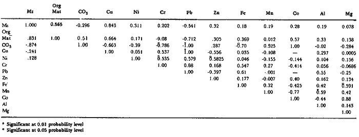 TABLE 3 CORRELATION COEFFICIENTS FOR TOTAL METAL CONTENTS IN SURFACE SEDIMENTS FROM PAPALOAPAN RIVER MEXICO Metal concentration is low in all the cores studied with high homogeneous distribution patterns (Table 4). There is a slight increase in nickel and chromuirn concentrations towards the surface in samples located in sampling point 1 which agrees with the increase in organic matter. Lead concentration was very low or non detected in the cores samples studied. Few correlations were found in the parameters studied in the cores from Papaloapan river (Table 5), the high magnitude of the Papaloapan basin allows the basin to be formed by different rocks outcrops which makes any correlation highly difficult to be found. 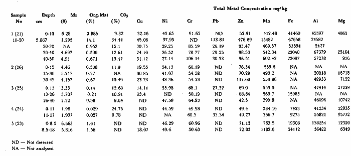 TABLE 4 MEAN GRAPHIC SIZE (Ø), ORGANIC MATTER (%), CARBONATES (%), TOTAL METAL CONCENTRATION (mg/kg dry weight basis) IN CORES FROM PAPALOAPAN RIVER MEXICO ConclusionesCONCLUSIONSPapaloapan river is formed by two sections: a high basin formed by the different rivers up to the joining point between Papaloapan river and Tonto river and the lower basin that corresponds to the development of the coastal plain with heights lower to 10 m above sea level. The river hydrological parameters and sediment characteristics reflect the influence of the main rocks that form the basin. The higher salinity values and high magnesium content in sampling point 11 support this view. The high magnitudes of the Papaloapan basin makes it difficult to find any significant correlation among the different parameters studied. Metal concentration in surface sediment was low throughout the system. Nickel, chromuirn and zinc concentration are higher in the sampling trips realized in May, this is attributed to industry discharges. An analysis of the results obtained in the cores studied shows generally low metal concentration with highly homogeneous distribution patterns, the sedimentological characteristics of the cores are a function of the location of the sampling points and the dynamic present at these points. 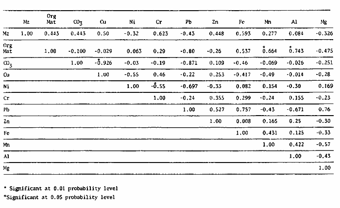 TABLE 5 CORRELATION COEFFICIENTS FOR TOTAL METAL CONTENT IN CORES FROM PAPALOAPAN RIVER, MEXICO. AgradecimientosACKNOWLEDGMENTSThe authors gratefully acknowledge the assistance of Joaquin Aguilar and Gabriel Sánchez in the processing of the samples. LITERATURABRULAND, K.W., B. BERTINE, M. KOIDE and E.D. GOLDBERG,Environ. Sci. Technol., History of metal pollution in southern California coastal zone. 1974.425-432. 8: FOLK, R.J., Petrology of Sedimentary Rocks.Hemphill Pub. Co.Austin, Texas1974. 182 p. FORSTNER, U. and G.T.W WITTMANN,Metal Pollution in the Aquatic Environment. Springer-Verlag New York 1981. 486. p. GAUDETTE, H. E_ W. R. FLIGHT, S. TORNER and D. N. FOLGER, Journal of Sedimentary Petrology, An inexpensive titration method for the determination of organic carbon in recent sediments. 1974.249-253.(1): 44 JONES, G.B. and M.E. JORDAN, Estuarine and Coastal Marine Science The distribution of organic material and trace metals in sediments from the River Liffey Estuary, Dublin.1979.37-47. 8: ROSALES, H.L., A. CARRANZA-EDWARDS, and ALVAREZ, R., An. Inst. Cienc. Mar. y Limnol. Univ. Nal. Autón. México, Sedimentological and chemical studies in sediments from Alvarado lagoon system, Veracruz Mexico.1986.19-28.(3): 13 SECRETARÍA DE RECURSOS HIDRÁULICOS (S.R.H.), Lluvias Medias Anuales por Cuencas, Regiones Hidrológicas y Estados de la República Mexicana.1975. S.P.P. Carta Geológica. Escala 1., 1.000.000, Hojas México y Villahermosa. Dirección General de Geografía del Territorio Nacional, Secretaría de Programación y Presupuesto.1981.
|