|
MARINE GEOLOGY OF LAGUNA SUPERIOR,
MEXICO
Trabajo recibido el 25 de abril de 1983 y aceptado para su
publicación el 12 de enero de
1984.
JOHN E. CROMWELL
Scripps Institution of Oceanography, La Jolla,
California 92093 Present address: Tetra Tech, Inc. 630 North Rosemead Blvd.,
Pasadena, California
91107.
La
Laguna Superior es la más grande de cinco lagunas interconectadas del
Istmo de Tehuantepec, en el sur del Pacífico de México. El norte
de la laguna es un valle de la Sierra Madre del Sur, a través de la cual
los vientos son empujados por la prevaleciente presión
barométrica mayor en la costa del Istmo del lado del Golfo de
México. Estos vientos predominantes dirigidos hacia el mar, han dado un
carácter poco usual no únicamente al clima de la región,
sino también en la geomorfología, hidrología e historia de
las lagunas de Tehuantepec y sus barreras.
La Laguna
Superior está aislada del efecto del Océano Pacífico por
dos lagunas más pequeñas (Mar Tileme y Laguna Inferior) y por una
excepcional barrera interna. Un bajo "standing stock" de foraminíferos,
limitada al intercambio del agua y a una falta de pantanos de marea, indica que
existe poco aporte de nutrientes en la Laguna Superior y sugiere que existe una
productividad baja.
La evidencia sedimentológica
sugiere que en los últimos 6,200-8,500 años, una barrera se
extendió hacia el este desde la boca del Río Tehuantepec. Como el
nivel del mar se elevó, esta barrera se construyó hacia arriba
sobre sí, manteniéndose sobre el nivel del mar y encerrando una
laguna atrás de ésta. Entre 7,500 y 3,000 años, cuando el
nivel del mar estuvo 2-4 m por debajo del nivel actual, la barrera antigua no
fue más grande conservándose arriba del nivel del mar. El
transporte litoral de los sedimentos costeros por el oleaje oceánico,
formó un gancho tierra adentro de la ubicación de la antigua
barrera. Esta barrera interna encerró la Laguna Superior. Puesto que el
nivel del mar se estabilizó en su posición actual, otro gancho de
barrera se formó sobre los sedimentos de la antigua barrera, en
dirección hacia el mar. Esta barrera externa capturó de mar
abierto los procesos litorales y encerró todo el complejo lagunar de
Tehuantepec. Subsecuentemente, la morfología y ubicación de la
barrera interna fue modificada en respuesta a la elevación del nivel del
mar y por la acción del oleaje y mareas dentro de la Laguna Superior,
inducido por los vientos de Tehuantepec dirigidos hacia el
mar.
Después de su rejuvenecimiento, la barrera
exterior o principal, periódicamente progradó sobre 4 km hacia el
mar por la acreción de los cordones de playa paralelos. La
migración de la boca hacia el este ha acompañado, aparentemente,
esta episódica progradación hacia el mar.
Los
vientos dirigidos hacia el mar también han producido muchas dunas o
bordes arenosos sobre las barreras dirigidas alargadamente en dirección
norte-sur. Sobre la barrera principal esto se combina con los bordes de playa
este-oeste para formar una topografía de tablero. Asimismo, los vientos
dirigidos hacia el mar transportan arena fina a través de las barreras
desde las playas lagunares, lo cual ha cubierto los bordes de playa de la
barrera principal y la ha elevado en un promedio de 2 a 3 metros preservando su
topografía.
Las desviaciones del Río
Tehuantepec, dentro de las lagunas durante los últimos 1,000
años, ha aportado sedimentos, los cuales fueron transportados por
acción del oleaje hacia la zona litoral de la laguna tanto de la barrera
principal como de la barrera interna. Como resultado ambas barreras han
progradado dentro de las lagunas por la acresión de bordes de
playa.
Laguna
Superior is the largest of five interconnected lagoons on the Pacific side of
the Isthmus of Tehuantepec in southern Mexico. North of the lagoons is a gap in
the Sierra Madre del Sur throught which winds are pushed by the prevailing
higher barometric pressures on the Gulf of Mexico side of the isthmus. These
prevailing, offshore directed winds have given an unusual character not only to
the climate of the region, but also to the geomorphology, hydrology, and
history of the Tehuantepec lagoons and their barriers.
Laguna
Superior is isolated from the effect of the Pacific Ocean by two smaller
lagoons (Mar Tileme and Laguna Inferior) and by a unique inner barrier. Low
standing stocks of foraminifera, restricted water exchange, and a lack of tidal
marshes indicate that there is a low nutrient replenishment in Laguna Superior
and suggest that there is a low
productivity.
Sedimentological evidence suggests that for the
past 6200-8500 years, a barrier has extended eastward from the mouth of the Rio
Tehuantepec. As sea level rose, this barrier built upwards on itself,
maintaining itself above sea level and embaying a lagoon behind it. Between
7500 and 3000 years ago, when sea level was 2-4 m lower than at present, the
old barrier was no longer maintained above sea level. Longshore transport of
coastal sediments by ocean waves formed a new spit inland of the location of
the old barrier. This inner barrier embayed Laguna Superior. As sea level
stabilized at its present position, another barrier spit was formed on the
sediments of the old barrier, seaward of the inner barrier. This outer barrier
captured the open ocean longshore processes and embayed the whole Tehuantepec
lagoon complex. Subsequently, the morphology and location of the inner barrier
was modified in response to the rising sea level and by the action of waves and
tides inside Laguna Superior, induced by the offshore-directed wind of
Tehuantepec.
After its rejuvenation, the outer or main
barrier episodically prograded over 4 km seaward by the accretion of parallel
beach ridges. Inlet migration eastward has apparently accompanied this
epísodic seaward progradation.
The offshore directed
wind has algso produced many north-south trending elongate blowout dunes or
sand strips on the barriers. On the main barrier these combine with the
east-west beach ridges to form a checkerboard topography. In addition, the
offshore-directed wind transports fine sand across the barriers from the
lagoonal beaches which has covered the beach ridges Of the main barrier and
raised their average elevation 2-3 m while preserving their
topography.
Diversions of the Rio Tehuantepec into the
lagoons during the past 1000 years have supplied sediments which were
transported by wave action to the lagoonal littoral zones of both the main
barrier and the inner barrier. As a result, both of these barriers have
prograded into the lagoons by the accretion of beach
ridges.
Laguna Superior is the largest of five interconnected lagoons on the Pacific side of the Isthmus of Tehuantepec in Southern Mexico (Fig. 1). The single communication of these lagoons with the Gulf of Tehuantepec -San Francisco Inlet- is located at 16º13' North latitude and 90º46' West longitude. The five lagoons of the Tehuantepec complex are the first of a chain of lagoons, beginning at the head of the Gulf of Tehuantepec and extending east and south along the Pacific coastal plain of southern Mexico into Guatemala. The Tehuantepec lagoons are separated from the sierra to the north by 20 km of flat coastal plain. The arid coastal plain and continental shelf of the Gulf of Tehuantepec interrupt the trend of the rugged Sierra Madre del Sur and offset it to the north. This offset is the location of a gap in the sierra through which the winds from the Gulf of Mexico are funneled to the Pacific side of the Isthmus of Tehuantepec. Laguna Superior and its associated lagoons are approximately 60 km long and 22 km wide at the widest point. They are formed by three sand barriers. The outer, main barrier embays the whole complex and separates it from the Pacific Ocean. The other two barriers are internal and are adjusted to conditions in the lagoons. These two inner barriers are gently concave to the north, oriented towards the source of the locally prevailing, offshore directed winds the gap in -the sierra. 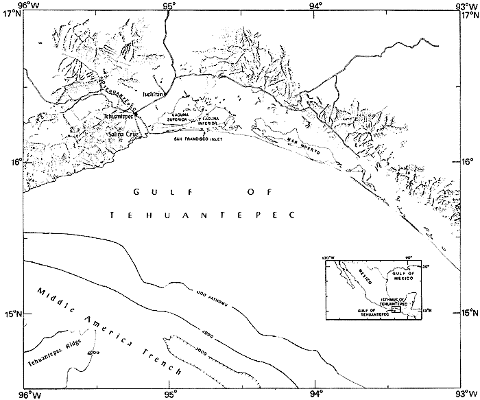 Fig. 1. Southern isthmus of Tehuantepec. The most famous aspect of Tehuantepec's climate is the often violent, offshore directed wind. These winds reach gale force on an average of 14 times a year (U. S. Hydrographic Office, 1951). According to Roden (1961) and Riehl (1954), the atmospheric pressure on the Gulf of Mexico side of the Isthmus is generally higher than on the Pacific side. This prevailing pressure differential drives wind through the gap in the sierra. As a result, the offshore directed, north winds dominate the wind regime of the Gulf of Tehuantepec through all seasons of the year. These winds exert considerable influence on the water exchange in the lagoons and on the morphology, vegetation, and Indian culture of the lagoon barriers. Because of its strategic location on one of the easiest routes from the Gulf of Mexico to the Pacific Ocean, the Tehuantepec area has been explored, described and mapped since the l6 th Century. By 1580, Spanish influence was significant in the area (Toscano, 1968; Taylor, 1972). Cortez is reported to have built ships in the Lagoons and sailed them towards the Californias in search of gold (Torres, 1580). In 1870, the United States Navy explored and surveyed the Tehuantepec area in order to determine the feasibility of constructing a ship canal across the isthmus from the Gulf of Mexico to the Pacific Ocean (Shufeldt, 1872). A transisthmian railroad was built in the late l9 th century (Gadow, 1908). An investigation of the Tehuantepec lagoon complex was conducted to: 1) examine the modern interrelationships between dynamic process, sediments and organisms; 2) determine how these interactions are reflected in the sediments and morphology of the barriers; and 3) reconstruct the history of development of the Lagoons. MATERIALS AND METHODSSamples of lagoonal sediment were collected from a launch with a Van Veen grab, a small gravity (Phleger) corer, and a pole-coring sampler. In addition, several samples were collected from a hovering helicopter using the same equipment. Foram samples from the lagoonal shallows were collected by hand with short lengths of core tube. A large number of surficial samples from the barriers, local rivers, the coastal plain and lagoonal margins and shallows were collected as well. Pits and trenches were dug on the barriers to examine and sample the stratigraphy of the upper meter or so of the barriers. Subsurface samples of the barriers were collected by a bailer rig (Fig. 2). Bulk samples were recovered with reasonably good depth control and a wire-line coring device recovered sections of relatively undisturbed sediments. Water level variations in the lagoons were recorded at several locations using a battery powered pressure sensor with a spring-wound recorder and a mechanical (float-pulley) recorder. In addition, relative water level variations at a large number of sites within the lagoons were estimated based on observations of berms and scarps perched high on the upper face of lagoonal beaches and of water-filled footprints and trenches along the lagoonal margins. A Bendix depth recorder was used from a launch while underway in Laguna Superior and these bathymetric results were calibrated against direct measurements made during sampling and against the bathyraetric maps of Consultores (1970). Positioning was maintained by compass bearings to distinctive landmarks identified on air photographs and charts. In addition, several topographic transects were made across the barriers using a surveyors transit. Laboratory analyses of sediments followed procedures recommended by Folk (1968). Finally, five samples, including shell and peat materials, were analyzed by 14 carbon techniques to determine their age, and a sediment core from Laguna Superior was sampled at intervals and these subsamples analyzed for age by 210 lead isotope techniques (Koideet al. 1972; Koide et al., 1973). 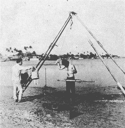 Fig. 2. Bailer sampler in operation. RESULTS
LAGOONAL BASINSLaguna Superior is an irregular basin 20.5 km wide, 33 km long and about 350 km² in area (Fig. 3). Santa Teresa Inlet, in the southeast corner, connects Laguna Superior to Laguna Inferior. Five major rivers flow into the lagoon, with an annual runoff of 1, 119 X 10 6m³ (Tamayo, 1949). The largest of these is the Rio de los Perros. The Estero Cantera, which flows into western Laguna Superior near Punta de Agua, is the main drainage of the local irrigation system. According to the maps prepared by the U. S. Navy (Shufeldt, 1872) and to charts of the irrigation system of Tehuantepec prepared by the Secretaria de Recursos Hidraulicos, the Estero Cantera appears to be a relict channel of the Rio Tehuantepec. Air photos of the region (see Fig. 4) show distinct meander patterns between the town of Tehuantepec and Punta de Agua. Punta de Agua and the western margin of Mar Tileme appear to be abandoned deltas of the Rio Tehuantepec. There are nearly a dozen islands extending east-west from the eastern shore across the central part of Laguna Superior. These islands vary in size and appearance from large islands several km in length to rock piles only a few meters long which barely rise above the surface of the lagoon. Rock samples collected from one of these islands, Cerro Cristos, were identified as fine-grained granodiorite.The lithologies of all the islands observed appear to be similar. There are two other islands in Laguna Superior, Cerro Mono and Cerro Tileme. These islands are prominent features of southern Laguna Superior and are steep-sided, distinctly circular, buff in color, and apparently volcanic in origin. There are small shoals between Cerro Tileme and Cerro Mono but no connecting structures were observed with the bathymetric recorder. 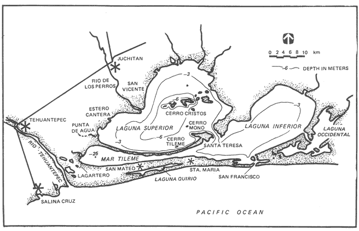 Fig. 3. Chart of the Tehuantepec lagoon complex. 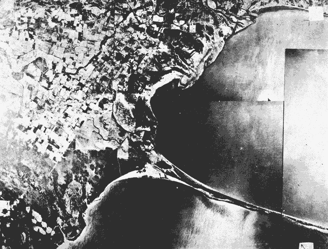 Fig. 4. Western. margin of Laguna Superior and Mar Tileme. The deepest part of the basin of Laguna Superior is around the central islands with depths of 6-8 m. South and west of the islands, the bottom rises slightly and levels off at 5-7 m, forming the major basin of the lagoon. Between the islands and the northern shore, the bottom shoals gradually. Just north of the narrow barrier between Laguna Superior and Mar Tileme, the bottom rises rapidly to form a shelf. This shelf is narrowest along the eastern inner barrier with a distinct break in slope at 3-4 m. In the middle of the barrier, the shelf is several hundred meters wide and has a slope break at 3 m. The shelf continues to widen and shoal towards the mainland to the west. The sediments of the Laguna Superior basin generally are dark olive gray, silty clays with some shells, and less than 5% sand. The sand content of these bottom sediments increases around the central islands and Santa Teresa inlet and near the western and southern margins of the lagoon. A layer of concentrated shells was encountered in gravity cores less than a meter below the surficial muds of Laguna Superior. Mar Tileme Mar Tileme is a narrow basin approximately 15 km long. It has a surface area of 40 km² and a maximum width of 5 km. A narrow channel with depths less than 0.5 m connects Mar Tileme and Laguna Inferior. Excess water of the local irrigation drains into abandoned channels of the Rio Tehuantepec some of which lead to what appear to be deltas along western Mar Tileme (Fig. 5). The sediments of the Mar Tileme basin are dark olive gray, silty clay containing 4-20% sand and a few mollusc shells. The sand content of the basin sediments increases rapidly towards the southern margin and the channel between Mar Tileme and Laguna Inferior. Lagoonal Margins The margins of the lagoon complex have little well-developed marsh. This lack of tideland is especially true for Laguna Superior. Only a few, small marshes and mangrove swamps are found, primarily around the mouths of rivers and estuaries and along the banks of the salina ponds. Most of Laguna Superior's shoreline consists of rocky headland, sandy beaches, and the mud flats of the northern shore. 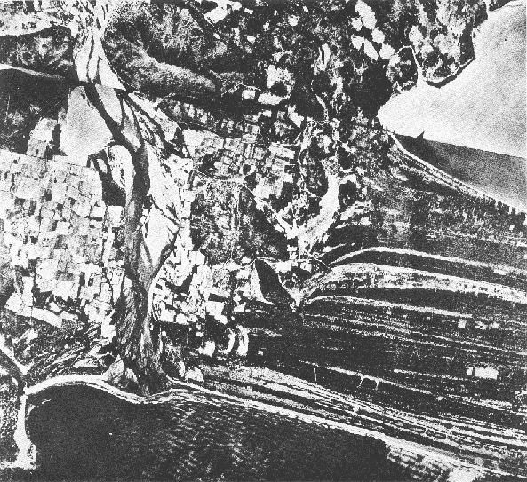 Fig. 5. Mouth of the Rio Tehuantepec and western margin of Mar Tileme The northern shore of Mar Tileme is also mud flat. The southern shore is sandy beach. The western shore of Mar Tileme is lined with reed-marshes and mangrove swamps. LAGOONAL HYDROLOGYMost coastal lagoons have direct access to the sea and its influence through their inlet or inlets. Such connections allow an exchange of water between the ocean and the lagoons, directly affecting the lagoonal salinity, temperature, water level, organisms, and other properties. The inlet of San Francisco is the single oceanic access for Lagunas Superior, Inferior, Oriental, and Occidental, and for Mar Tileme. Laguna Inferior communicates directly with the Pacific through San Francisco Inlet. Laguna Superior and Mar Tileme, as well as the small eastern lagoons, communicate only with Laguna Inferior through their respective inlets. Consequently, the influence of the Pacific Ocean is felt in Laguna Superior and Mar Tileme only after passing through two restricting inlets and the basin of Laguna Inferior. The water exchange between any two connected basins is governed by the size of the connection and the hydrostatic head or relative water level between them. In most coastal water bodies, the hydrostatic heads at inlets are a product of local net-runoff (rivers and ground water reflux less evaporation) and local tides. In most temperate coastal lagoons, the volume of the ebb tide exceeds that of the flood tide by the amount of the net runoff. The oceanic tides for the Gulf of Tehuantepec are mixed, predominantly semi-diurnal with a maximum recorded range of 2.41 and a mean range of 1.09 m (Tablas de Mareas, 1973). Consultores (1970) made tidal measurements in both San Francisco and Santa Teresa Inlets and Cromwell (1974) made tidal measurements at seven different sites in the lagoons. These measurements and observations of water level variations within the lagoons make a number of generalizations possible: 1. The tides within Laguna Inferior are semi-diurnal and on the order of 10-20 cm. 2. The tides within Mar Tileme and Laguna Superior are dominantly diurnal and are on the order of 2040 cm. 3. The effect of the oceanic tidal prism is essentially restricted to Laguna Inferior. Von Arx (1948), Haurwitz (1951), Rex (1960), Wiegel (1964), Groen (1969) and Tait (1972) show that wind may entrain surface water and pile it up on the down-wind shores of enclosed water bodies and open ocean coasts. Such wind tides in the Tehuantepec lagoons would counteract the hydrostatic head of the local flood tides at the inlets and accentuate the ebb tides. As mentioned above, the major factors of the lagoonal. water budget are runoff, evaporation, and tidal exchange. The Tehuantepec lagoons receive an annual runoff of 1.81 X 10 9 m³ (Tamayo, 1949). Of this, Laguna Superior receives 1. 12 X 10 9 m³ annually. The Benito Juarez Dam impounds the annual flow (5.8 X 10 9 m³) of the Rio Tehuantepec. Most of this water is used for irrigation of the fields surrounding the lagoons. Runoff from irrigation would be fairly constant all year round in the ameliorated climate of Tehuantepec while the natural runoff into the lagoons would be seasonal. Evaporation rates at Juchitan are measured by representatives of the Secretaria de Recursos Hidraulicos. Although the technique used for these measurements is not known, between 1969 and 1972, the average rate of evaporation was 26.5 cm/month or 316 cm/year. A conservative estimate of the evaporation rate for the lagoons would be 200 cm /year. Using this rate and ignoring the seasonal rainfall, the lagoons (650 X 106 m² surface area) would lose approximately 1300 X 109 m³ per year or close to 3.6 X 10 6 m³ per day, roughly 70% of the natural runoff to the lagoons. Thus, evaporation may cause a net flow of seawater into the lagoons, especially during the Summer dry season. Where evaporation dominates the hydrology of coastal water bodies such as the Red Sea (Siedler, 1969), Ojo de Liebre Lagoon (Phleger and Ewing, 1962), and Guerrero Negro Lagoon (Phleger, 1965) hypersaline conditions result. San Antonio Bay (Parker, 1955; Parker, 1960; and Shepard and Moore, 1960) is an example of a lagoon which is hypersaline during droughts and brackish at other times. The salinity of Laguna Superior and Mar Tileme appear (on the basis of two sets of observations) to vary from hyposaline (14-220‰) to slightly above normal marine salinity 34-38‰). Much higher salinities (greater than 40‰) were frequently observed on the mud flats of the lagoons and the shallow inlet of Mar Tileme. It appears that local runoff and water exchange with Laguna Inferior are sufficient to prevent Laguna Superior from becoming completely hypersaline. Lagoons are widely recognized as important spawning and nurturing grounds for a number of commercially valuable fish and crustaceans. This important function of lagoon is based on nutrients supplied by tidal exchange, rivers and tidal flushing of associated marshes. These nutrients are retained and concentrated in the sheltered water of lagoon basins (Guilcher, 1958; Cardenas, 1967; Gunter, 1967; Postma, 1967). The availability of nutrients (Rhyther, 1966; Goldman et al, 1973) controls and limits the rate of organic productivity in water bodies. High nutrient levels allow high organic productivity. The lagoons of Tehuantepec are nursery grounds for postlarval shrimp which are the base of the offshore shrimping industry of Salina Cruz. The importance of the lagoons to this industry was emphasized by the natural clossure of San Francisco Inlet in 1968. Without exchange between the lagoons and the ocean, the shrimp catch for 1968 was valued at twenty million pesos as compared to fifty million pesos for the preceding years (Consultores, 1970). The value of maintaining a permanent communication between the lagoons and the Pacific has been estimated at more than twenty-five million pesos per year (Direccion, 1970). Tidal marshes are one of the major sources of nutrients for most coastal lagoons because of the ability of marsh organisms, especially algae (Rhyther and Dunstan, 1971), to supply nitrogen compounds and other nutrients and the flushing action of tides to bring the nutrients into the lagoons. Marshes and swamps surrounding Laguna Superior are limited in extent. The flow of nutrients from these normally nutrientrich areas is low because the windgenerated tides of Laguna Superior are not effective in flushing the marshes. The replenishment of the nutrients of Laguna Superior by water exchange through Santa Teresa Inlet appears to be inefficient. The volume of water passing through the inlet per day is estimated to be less than 2% of the gross volume of Laguna Superior. In addition, the water that does enter Laguna Superior does not come direaly from the ocean but is secondhand, from Laguna Inferior. As a consequence, Laguna Superior may not support a large exploitable population of fish and shrimp. GEOLOGY OF THE BARRIER
Main Barrier The main barrier of Laguna Superior is a slightly sinusoidal, sandy spit, 4.5 km across the base and 40 km long. Eastward from the base, the barrier tapers gradually and in steps to a double spit at San Francisco Inlet (Fig. 6). The mean elevation of the barrier is 2-3 m above sea-level. However, there appears to be a slight but general increase in elevation towards the center. The highest elevations of the main barrier are near San Mateo del Mar with a mean elevation of 4-5 m above sea-level. At the base of the main barrier are a number of low foothills of the Sierra Madre del Sur. The ocean beaches of the main barrier are exposed to the surf of the Gulf of Tehuantepec. The offshore winds of the region appear to reinforce the steepness and violence of the breakers. During períods of heavy surf and offshore winds, the drawback of the swash regularly exposes rounded pebbles and cobbles at the base of the breakers. This is most noticeable along the western beaches of the barrier. The buff-brown beach sediments of the main barrier vary from moderately sorted, multi-mineralic, medium sands on the upper beach face to very poorly sorted, coarsely skewed, gravelly sands in the surf zone. A variety of shells are found on the upper beach face. Carbonate material is, however, less than 6% by weight of the beach sediments. 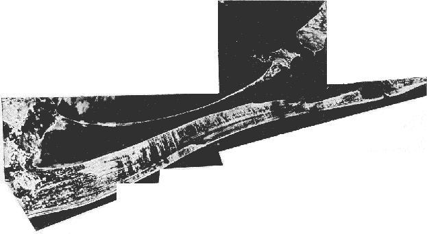 Fig. 6. Barriers of Laguna Superior and Mar Tileme. Both beach face slope (10-6º) and median grain diameter (1.4-0.3 mm) of the beach sediments decrease with distance from the western end of the barrier and the mouth of the Rio Tehuantepec. The lateral decrease of beach slope and related median grain diameter reflects the sorting action of the waves transporting the sediments of the Rio Tehuantepec along the shore to the east. The ocean beaches of the main barrier consist of from one to three low (1 m or less) but distinct berms, 30-50 m in width. North of these low berms are parallel beach ridges usually covered with grasses and sometimes low shrubs and trees. Along the base of the main barrier, the elevation of these beach ridges is only slightly higher than that of the beach berms. The height of these ridges above the beach gradually increases to the east and reaches 5 m in relief and elevations of 6-7 m above sea level between San Mateo and Santa María. The morphology of the main barrier is dominated by these east-west beach ridges and intervening swales (Fig. 6). The northernmost of the beach ridges of the main barrier, along the shore of Mar Tileme and Laguna Inferior, are capped by high dunes 200-300 m wide, 5-8 m in relief, and up to 10 m above sea level. These dunes have well-developed internal cross bedding overlain by structureless, reddish sandy soil 1 m thick. This soil is penetrated by the roots of the locally dominant spiky grassesJouvea pilosa and Distichlis spicata as well as sedges, cacti, low growing bushes and gnarled buttonwood trees (Conocarpus erecta L.). The beach ridges to the south are lower (1-2 in relief) and appear to come in groups, of 4-6 ridges. The average width of the beach ridges increases to the east. Their width averages 80 m near the base and only 50-60 m near Santa Maria. The differences between the Tehuantepec beach ridges and those of Nayarit described by Curray et al (1969) and of Tabasco described by Psuty (1966) are in spacing, relief, and, where the descriptions are adequate, in elevation above sea level. The width of the Nayarit beach ridges average 50 m (0-200 m) and their elevation vary from -0.5 to 1-2 m and locally up to 4 m above sea level. The width of the Tabascan beach ridges average 45-50 m (0-20 m) and their relief averages 1 m, with elevations ranging from 0.3 to 3.9 m. The beach ridges at the base of the main barrier have a dense forest cover, perhaps as a result of more abundant or less saline ground water. This dense growth, dominated by thorn forest, thins out to the east, where the ridges are sparsely covered with grasses, cacti, and scattered clumps of trees dominated by species of the Legume family. Near the mouth of the Rio Tehuantepec are two distinct lines of beach ridge truncation (Fig. 5). North of the first of these unconformities, the ridges are covered with dense vegetation. South of this unconformity, however, the land is more open and the ridge and swale topography less subdued. In addition, oxbow lakes and meander patterns adjacent to the river mouth truncate both the unconformities and the western-most ridges and swales of the maín barrier. The morphology of the main barrier is also distinguished by north-south trending strips of deflation and sand transport (Fig. 6). Bagnold (1942) stated that in a strong, sand-laden wind, a uniform drift of sand over a uniform rough surface has a transverse instability, so that sand tends to deposit in longitudinal strips. These sand strips tend to grow thicker in strong winds, by collecting more sand from the sides. Gentle winds tend to disperse sand laterally. The north-south elongate features of the main barrier are undergoing deflation as well as deposition. Melton (1940) termed similar features elongate "blowout dunes." The orientation of the blowout dunes on all of the barriers of the lagoons is parallel to the prevailing offshore winds of Tehuantepec. These blowout dunes are best developed and most concentrated in the vicinity of San Mateo del Mar, direaly south of the wind gap in the sierra north of the lagoons. Elongate blowout dunes are not common at present between San Mateo. and Santa Maria. There are, however, what, appear to be many relict blowout dune scars. The main barrier between the beaches of the Pacific Ocean and the lagoons is composed of three basic sediment types. First, the buff, well to moderately-well sorted, medium to fine sands of the blowout. dunes and upper sediments of the east-west trending ridges and dunes; second, the thin surficial layer of gray, poorly-sorted, sílty fine sands of the swale basins; and thirds, the brown to buff, moderately sorted, medium to coarse, multi-mineralic sands below the layer of fine sand and dunes which cover the barrier. This last sediment type is identical to the sediments of the upper face of the Pacific beach of the main barrier. Intersections of the north-south blowout dunes and the east-west ridges and swales produce a checkerboard topograhpy with many isolated basins on the main barrier. Ponded water promotes the deposition of fine sands, silts, and clay in the bottom of these basins. These fine sediments reduce the porosity and the drainage capability of the lowermost sediments, increasing the ponding ability of the basins. Below the basins and swales, the sediments get rapidly coarser and better sorted. Laguna Quirio, south of San Mateo, is 12 km long but only several hundred meters wide, except where tenuous conections with the Pacific are maíntaíned. Laguna Quirio is separated from the Pacific by at least six ridges, a distance of about 0.6 km, for most of the length of the lagoon. Laguna Quirio was first mentioned and indicated on a U. S. Navy map made in 1870 (Shufeldt, 1872). Along the Laguna Inferior shore of the main barrier are a number of orthogonal, step-like features in the shoreline. The orthogonal features of the eastern main barrier are associated with narrow beaches, wave cut scarps, and outcrops of reddish beach rock. Two curved spits at the eastern tip of the main barrier form the western side of San Francisco Inlet. Between the low hills on the base of the main barrier and the shore of Mar Tileme to the north are a number of low ridges. These ridges are concave north and are composed of firm sandy mud covered by a thin layer of sandy shell material. Inland of these ridges, near the Lagartero, are thick deposits of shell. These shells are almost entirely Cerithidea mazatlantica, a gastropod common to lagoonal intertidal flats. The beach sediments along Mar Tileme and Laguna Inferior vary from shelly sands, through coarse gravels, to poorly-sorted medium sands. Samples taken from pits and bailer holes show that the beaches are composed of interlayered medium to coarse sands and shelly sands. The carbonate content, identifiable as shell materials, of these beach sediments is considerable. The carbonate component of the beach sediments decreases eastward from 96% near Lagartero to 21% near Santa Maria. Offshore, the surficial sediments of Mar Tileme and Laguna Inferior are finer and better sorted. These greenish gray silty sands usually contain 9-10% carbonate material. Inner Barrier In a letter to the King of Spain, Torres (1580) described the inner barrier as an island (ysla) or arm of land (manga de tierra firme). He also described the main barrier as an ysla. It would appear that ysla in both instances should be translated as "spit". The inner barrier is presently less than 1/2 km wide throughout most of its length (see Figure 6). The barrier widens where its western end joins the mainland and where its eastern end joins the highlands at Santa Teresa Inlet. The inner barrier appears to be a lens of sand resting on lagoonal sediments. This barrier has a smoothly curving sand and, shell beach facing Laguna Superior. Behind the beach is a dune ridge which is essentially continuous along the length of the inner barrier. Behind the dune ridge is an irregular band of dense vegetation separated from the mud flats of Mar Tileme by a low and continuous shell berm. These shells are predominantly Cerithidea mazatlantica but also include Cerithium stercusmuscarum as well as several species of pelecypod. These molluscs are common along the low-energy margins of the lagoons. The vegetation which grows along the uppermost margin of the mud flat is dominated by black mangroves (Avecinnia nitida) and the halophyte,Batis maritima. The base and pneumatophores of these mangroves are covered by the shell berm. At higher elevations and generally better drainage, the mangroves are replaced by coastal trees such as acacias and mesquites, cacti, and other salt tolerant, draught resistant shrubs and trees. A small well-sheltered and very shallow bay restricts the connection between the highlands and the wide eastern end of the barrier (see Fig. 6). A fan-shaped swamp has grown between the wide dunes of the eastern inner barrier and Laguna Inferior and adjacent to the bay. The red mangrove (Rhizophora mangle) grows round the margin of this bay. Rhizophora is not common along the margins of the lagoon complex. The sediments of the dunes of the inner barrier are buff, well sorted, medium to fine sand. These sands are dominantly quartz, feldspar, calcite and mica. Frequently, the sands will have layers of nacreous flakes derived from the breakdown of shells. The dune ridge of the central inner barrier has become a number of north-south oriented shrub-coppice dunes more or less separated by deflation basins. The northern ends of these dunes are anchored by stands of gnarled, windbent trees which appear to be buttonwood. The sides and upper surface of the dunes are covered and stabilized by sedges, grasses such as Jouvea pilosaand Distichlis spicata, flat pad cactus, and thistles. Sand blown through gaps in the dune ridge forms ribbons of sand which extend across the mud flat and sometimes into Mar Tileme. There is a shallow basin between the Laguna Superior beach berm and the dune ridge rear base of the inner barrier. This basin is a commercial salina. The barrier beach on the Laguna Superior side of the salina basin is being eroded and is maintained with sand bags and by the construction of small groins extending into the lagoon. Just east of the salina, truncated beach berms form the backshore. The topography of the dune ridge is subdued as it passes south of the salina basin. The gentle curve of the ridge may be traced, however, for a kilometer into the forests of the mainland (see Fig. 4). The inner barrier beaches along Laguna Superior are poorly sorted, multi-mineralic, medium to coarse sands with varying percentages of shell carbonate. At both ends of the barrier, the sands average 30-40% of carbonate material. Along the barrier beach of the salina, concentrated shells, predominantly , Cerithideamake up nearly the entire bulk of the littoral sediments. Near the eastern end, the shells are dominantly pelecypods. The beach sediments become less shelly (4-5% carbonte), finer, and better-sorted towards the center of the inner barrier. Although most of the finer sized sediments are swept off the beaches by the north winds, north dipping layers of fine sands and coarse, sometimes shelly, sands are interlayered in the beaches along Laguna Superior. Pits, trenches and bailer samples show the coarse shelly sands to extend 1-2 m below the calm water level of the lagoons. Olive gray sediments with a high content of silt and clay are associated with the wind-tide flats along the northern shores of Mar Tileme and Laguna Superior. The mud flats of both lagoons are essentially identical. They are 100-250 m wide and have slopes less than one degree (1:100). Where constantly subinerged, sediments of the margins of the mud flats are algae-rich, yellow-brown, sticky mud. The average daily fluctuation of water level in Mar Tileme and Laguna Superior is about 20 cm. This results in horizontal oscillations of the shoreline on the order of tens of meters. Bordering the water is a thin layer of soft mud which is frequently subinerged by these oscillations. The lateral extent of the soft martinal ooze is controlled by the lateral extent of these frequent inundations. Below this layer is a firm, dark brown gray gritty, silty clay, usually containing some shells-mostly Cerithidea mazatlantica. At higher elevations, where there are longer periods of exposure, the soft, muddy surface is replaced by algal and evaporite crusts and dessication cracks. These features give the higher flats a light blue-gray color and rough blocky appearance. The dark gray gritty sediments below the crust have disseminated gypsum lathes as well as scattered shells. Farther downward, these dark gray muds grade into gray-green silty fine sand. At higher elevation and closer proximity to the barrier and the berm of the north shore of Laguna Superior, the sand and shell content of the surficial sediments of the flats increase. The higher proportion sand and shell to clay reduces the overall cohesion of the sediment and thus reduces the occurrence of dessication cracks. SEDIMENTARY PROCESSES
Lagoonal Beaches Mar Tileme and Laguna Superior have small, diurnal windinduced tides associated with the daily wind pattern of Tehuantepec. In a manner similar to the tides of the ocean, though on a smaller scale, the wind-tides modify the profiles of the lagoonal beaches by extending the vertical range of the active surf. The north facing beaches of the barriers are subject to short-period waves created by the nearly unidirectional, offshore directed winds blowing across the fetch of the lagoons. This contrasts to the variable sea and swell from a number of sources which breaks on the Pacific beaches. Waves up to 1m in height break on the north-facing beaches of the barriers for several hours after storms with gale force winds. Wave-cut scarps and berms perched well above normal water levels are the result of these high energy waves in concert with the raised water levels of attendant storm tides. This is especially evident along the beaches of the inner barrier where the fetch across Laguna Superior is generally greater than 10 km. The breaking waves induce a slight but prevailing movement of littoral sediment towards the center of the inner barrier. Evidence of this movement along the western portion of the barrier is the consistently greater accretion on the western side of groins and jetties built out from the beach of the salina, the observed eastward movement of dyed sediment in the nearshore (Sanchez, 1972), and observations of eastward, lateral accretion of new berm to the beach face. In addition, sedimentary features such as narrow beaches fronting wave-cut dunes, truncated beach ridges, and outcrops of beach rock indicate that erosion and transport are active at both ends of the inner barrier. Erosion of either end of the inner barrier is offset to some extent by an input of molluscan shells from the adjacent shallows. Along the western inner barrier, the beach erosion is also reduced by an input of sediment from the erosion of adjacent Punta de Agua and by sandbagging the barrier beach of the salina. The lagoonal beach of the western inner barrier appears to have been prograded by the accretion of low beach ridges formed by "bermwelding" (Cromwell, 1974). These beach ridges were gradually covered by vegetation and fine aeolian sand which raised their elevation but preserved their topography. The lagoonal beaches of the main barrier appear to have prograded by a similar process of accretion. Erosion of the shelly sand berms of the main barrier beaches adjacent to the widest fetches of Mar Tileme and highest incident wave energy has produced narrow beaches, truncated beach berms, and wave-cut scarps in the dune faces, and may also have exposed outcrops of beach rock and coquina. The direction of transport of these eroded sediments appears to be into the basin of Mar Tileme where a layer of sand overlies lagoonal muds up, to 50m offshore and depths over 1m. Aeolian Processes The north winds of Tehuantepec winnow the lagoonal beach sediments and dune deposits of the barriers and leave localized concentrations of pebbles and shells (lag deposits) on the beach and in the deflation basins. The fine sand winnowed from these deposits is carried by the wind across the barriers as individual suspended grains or in blowout dunes. Vegetation stabilizes most of the surface of the barriers and traps wind-blown sand, inducing deposition of the aeolian sediments (Bagnold, 1942). On the narrow inner barrier beach, sand may be rapidly lost by being blown over the dunes and into Mar Tileme. The main barrier, however, is blanketed by a 1-2 m thick layer of fine aeolian sand which preserves the initial topography of the barrier while increasing its general elevation. Southward transport of fine sand across the main barrier is most effective in the elongate blowout dunes. Mud Flats There is desposition of silts and clays from the turbid water on the mud flats of Laguna Superior and Mar Tileme. This deposition is extended onto the mud flats by wind induced fluctuations of the water level. Only during infrequent periods of high onshore winds are the wind-tidal flats completely covered by water and subject to an active surf. The abundant algae along the margins of the lagoons enhances the deposition of fine sand and mud and stabilizes it once deposition occurs (Ginsberg and Lowenstam, 1958; Neuman et al., 1970; Scoffin, 1970). Shrinkage cracks occur on the flat surface where the lateral transgression of the waterline is not sufficiently frequent to keep the sediment from dessicating. Inlet At San Francisco Inlet (see Fig. 6), the sediments, ocean waves, semi-diurnal soli-lunar tides, and littoral currents of the Pacific nearshore zone are juxtaposed with the sediments and wind-induced waves, tides and currents of Laguna Inferior. The two curved spits of the western side of the inlet reflect these two, separate dynamic systems as well as the bi-directional flow of the tidal prism. At present, the narrow bay enclosed by the two spits is filling with sediments transported into the inlet from the Pacific nearshore zone by flood tides and from Laguna Inferior by ebb tides. This active sedimentation is consolidating the two spits and extending the sub-aerial barrier to the east. The configuration and relative position of inlet spits has varied since 1870, but no significant migration of the inlet has occurred. Research by Inman (1950), Redfield (1965) Hoyt and Henry (1965) and others suggests that lagoonal inlets normally migrate in the direction of net littoral drift. Impedance of this natural migration by man or nature may induce the inlet to close by filling with sediment (Inman, 1950). The author believes that the orthogonal features along the inner margin of the main barrier are past locations of the inlet. The location of these features indicate migration of the inlet to the east accompanying the seaward progradation of the main barrier. At present, however, migration of San Francisco Inlet may be constrained by an inability of the tidal prism to erode the mass of the compound spit east of the inlet. This constraint of the eastward migration of San Francisco Inlet may cause natural closures of the inlet such as occured in 1968 (Consultores, 1970). San Francisco Inlet was reopened in 1969 by breaching of the barrier beach across the inlet after heavy seasonal rain. Pacific Beaches The prevailing offshore directed winds of Tehuantepec may influence the configuration of the incoming waves and thus the sedimentary processes of the Pacific shore zone. King (1959) observed that, in nature, strong onshore winds generate steep local waves (sea) which reduce or even reverse the accretionary effect of the longer period waves (swell). Strong offshore winds were observed by King to reduce the height of approaching swells, creating flatter waves which moved material up the beach face and steepened the profile of the beach. King further suggests that the offshore winds superimpose an onshore bottom circulation on the bottom currents generated by shoaling waves. The effect of the offshore winds would be to promote accretion along the Pacific beach of the main barrier. During periods of offshore winds, the Pacific surf is a surging type, breaking direaly on coarse gravels exposed at the foot of the steep beach face during the extreme drawback of the breakers. Violent surf often concentrates the coarsest material available, such as the pebbles and cobbles of the Tehuantepec nearshore zone, at the plunge point. The damming of the Rio Tehuantepec in 1950 cut off a major source of sediment for the nearshore zone of the Gulf of Tehuantepec. In the past, natural processes diverted the river and interrupted the flow of sediment. During these periods, the depletion of the nearshore sediment budget appears to have resulted in erosion of the main barrier adjacent to the mouth of the river, truncating the east-west ridges and suggests that wave activity occurred within the mouth of the river itself. Since 1950, however, a barrier beach has formed across the river mouth, smoothly connecting the curved beach west of the Rio Tehuantepec and the beach of the main barrier. The cove just west of the mouth of the Rio Tehuantepec, La Ventosa, was used in the past as an anchorage (Shufeldt, 1872) but is now too shallow (U. S. Hydrographic Office, 1951). Perhaps the mouth of the river is much more filled by sediment and the adjacent shelf is shallower at present than in the past. An annual net-eastward transport of 94,640 m³ of sediment across the mouth of the San Francisco Inlet was calculated from wave data for the Gulf to Tehuantepec by Consultores (1970). A wrecked freighter on the beach between San Mateo and Santa Maria del Mar disturbs the normally obscure sedimentary processes along the beach and emphasizes the eastward transport of sediments and the progressive lateral accretion of berms. Since it ran aground in 1970, several new berms have partially incorporated the 6000 T freighter within the barrier. In the Spring of 1973, a new berm had formed to the west of the ship but the berm's lateral progress had been interrupted and it did not continue east of the freighter. The continuity and regularity of the eastwest trending beach-ridges of the main barrier suggest that the sedimentary processes responsible for their formation are repetitive and even periodic in nature. Raised water levels shift beach profiles landward and upward (Brunn, 1962; Schwartz, 1967). Phleger (1965) and Psuty (1966) suggested that beach ridges may be formed by the consolidation of beaches into large storra berms during the raised water levels (setup) and high wave activity associated with large offshore storms. Weather records of the Secretaria de Recursos Hidraulicos indicate that storms in the Gulf of Tehuantepec lasting over three days and with daily mean wind velocity over 10 m/s occur 1014 times each year. This frequency of storms makes it difficult to assign any particular berm to a given storm. Shepard (1960; 1963) pointed out, however, that only coarse debris, gravels and shells and not sand (such as compose the beach ridges of the main barrier) are thrown up on shores as storm beaches more than a meter above the tide. Curray et al (1969) postulate that for Nayarit, particular combinations of wave energy, tides, water levels, sea breezes and sediment input rates allowed offshore bars to emerge in front Of an already existing beach and capture the local beach processes, isolating the original beach. The spacing of the beach ridges of Nayarit, are thus thought to reflect the original spacing between offshore bars and the beach. Progradation through littoral capture by emergent offshore bars has never been observed along an open-ocean shore, especially one exposed to high-energy waves. The "berm welding" observed inside Laguna Superior is believed to be responsible for the formation of the low, regularly spaced beach ridges on the lagoonal beaches of both barriers. A similar process, though on a larger scale and driven by a more complex wave regime than exists in the lagoons, is postulated as forming the low beach ridges along the Pacific shore of the main barrier. The beaches of the main barrier are composed of from one to three low sand berms. The outer berms appear to constitute the "active" beach, that is, the portion of the shorezone which undergoes periodic (seasonal or less) erosion and construction. The innermost of these berms are beach ridges which are gradually covered and stabilized by vegetation. The vegetation cover captures wind-transported sand and induces deposition. Consequently, a blanket of fine sand increases the elevation of the beach ridges but preserves their topography, reflecting the spacing of the original beach berms. The active beach berms are the result of the interaction of the local wave regime, tidal range, sediment supply, and the mechanical properties of the beach sediments. STRATIGRAPHY OF THE BARRIERSCuttings and cores of subsurface sediments were recovered using a bailer at 12 sites on the barriers (Fig. 7) . These sites are located in three lines crossing both barriers. Zero elevation for each bailer hole was made in reference to the mean water level of the lagoons, assumed to be equivalent to mean sea level. Holes 2 and 10 are located on what appears to be the initial spit of the main barrier which existed as sea level stabilized at its present position. This spit was located from the configuration of the beach ridges and their relation to the low hills in the base of the main barrier. Holes 1, 7 and 11 are lagoonward of this initial spit and Holes 3 and 8 are seaward. On the basis of mineralogy, texture, faunal content, and stratigraphic position, the sediments of the subaerial barriers are grouped into four basic facies: the sediments of the modern inner barrier and initial spit of the main barrier; modern, lagoonally prograding beach sediments; seaward prograding beach sediments; and aeolian sand. Similarly and by the comparison of these sedimentary characteristics to those of modern lagoonal and barrier facies, the subsurface sediments of the barriers are grouped into three basic facies: basal transgressive deposits, lagoonal sediments, and open ocean nearshore and barrier spitplatform sediments. Figure 8 is a composite cross-section illustrating the stratigraphic relations of the subsurface and modern sedimentary facies. In figure 8, all bailer holes are projected onto the cross-section of line B-B' and centered on the assumed initial spit of the modern main barrier. Basal Transgressive Deposits Holes 4, 5, 6, 11 and 12 bottom in a very stiff, gritty clay. This clay is dark to light gray and contains small (1-3 mm) lathes of gypsum and sometimes rounded granules of gravel. Directly above this clay are sharp, contacts with pebbly sand or gradational contacts with light olive gray or dark gray, gritty muds with occasional shell or peat material. These grade upward into gray to olive gray silty, fine sands. 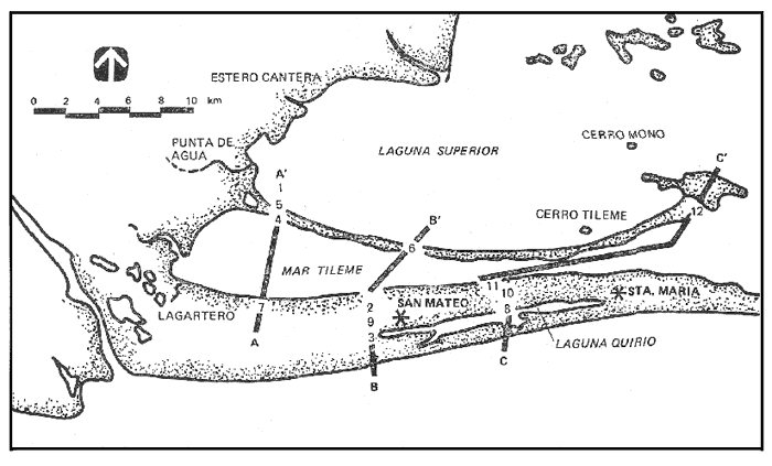 Fig. 7. Subsurface sampling sites 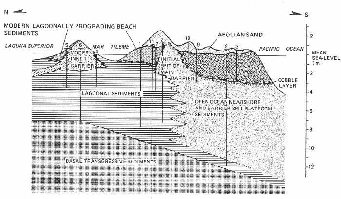 Fig. 8. Cross-section of barrier platform.. These lowermost sediments are identical to the gritty muds found at the margins of the mud flats of Laguna Superior and Mar Tileme. The stiff gritty clay appears to be a surface with a slope to the south of less than lo., and a slight concave-up curvature east to west. This firm surface and the muds and fine sands which overlay it are interpreted as the initial deposits of the transgressing shoreline during the last stage of the Holocene rise of sea level; semi-indurated muds of a dessicated tidal flat overlain by lagoonal muds and silty sands. Lagoonal Deposits In the lower portions of Holes 1, 2 and 7 and overlying the basal transgressive deposits, are sediments of diverse but intergradational character. They can be roughly subdivided as poorly sorted, olive gray to gray, pebbly and shelly, medium to coarse sands; moderately sorted, light olive gray to gray, medium fine and silty sands; and light olive gray to dark gray muds. The often pebbly, shelly, coarse sands and the medium-fine and silty sands commonly contain 30-40%, and 5-10%, carbonate, respectively, made up of lagoonal-molluscan assemblages. The most common species of these assemblages are: Cerithidea mazatlantica Neocyrena fortis Cerithium stercusmuscarum Cardita radiata Mytella falcata Trachycardium procerum Protothaca cf. P. grata Donax sp. A. Forams are also preserved in these sediments. The foram assemblages are small, with only a few species present. These species are usually associated with lagoonal deposits: Ammonia beccarii vars,Elphidium spp., andAmmotium salsum. The muds usually contain a few molluscs such asNeocyrena fortis, Protothaca cf. P. grata,andPododesmus cepio, but no forams. A mixed assemblage of lagoonal and open ocean forams along with several lagoonal molluscs are in the muddy sands and olive gray silty sands between -13.5 and -14.5 m in Hole 8. The shelly coarse sands with relatively high carbonate content are equated with the sediments of the modern lagoon beaches, the medium-fine sands and silty sands with moderate carbonate contents are equated with the sediments found along the margins and in the shallows of the lagoons and the gray muds are equated with the muds of the lagoon basins. The most logical source of the pebbles in the subsurface samples is the Rio Tehuantepec. Many of these pebbles were found 30-40 km east of the present mouth of the Rio Tehuantepec. Open ocean waves are the only reasonable mechanism for transporting these large clasts over such distances. Pebbles and even cobbles are transported by wave action along the Pacific shore and are presently found in San Francisco inlet. Shepard and Moore (1960), Hoyt and Henry (1965) and others have suggested that inlet migration and the incorporation of inlet sediments is of great importance in the formation of barrier spits and that the bulk of sediments below subaerial barriers are likely to be inlet deposits. As the main barrier was extended eastward by inlet migration, built upwards as sea level rose, and then bulit seaward by accretion, lower beach face and inlet deposits containing pebbles were incorporated into the sediments of the barrier. Pebbles associated with sand containing many lagoonal molluscs are believed to be comparable to the modern beaches of the orthogonal features on the main barrier, i. e., lagoonal beaches containing reworked inlet deposits. When pebbles are associated with shell-less, poorly sorted coarse sands, they are believed to be comparable to the modern open ocean nearshore or inlet deposits. Open Ocean Nearshore and Barrier Spit-Platform Sediments The sediments recovered from Hole 8 range from very poorly sorted pebbly gravels to moderately sorted, coarse to medium-fine and fine sands. The color of these sediments ranges from light brownish gray to gray. From -2 m to -10 m, only a few specimens of the molluscNeocyrena fortis and several specimens of the foramElphidium spp. were found. Below -10 m, however, gray silty clay lumps appear in the fine to medium-coarse sands along with a specimen of a micro-mollusc Nocula Schenki and a large and diverse foram assemblage. This assemblage is a mixture of cosmopolitan, lagoonal, and open ocean forams. Open ocean species, indicated by asterisks, dominate the assemblage which include: Elphidium spp. *Florilus basispinata *Globigerina bulloides and Textularia spp. Ammotium salsum *Globorotalia siphonifera Cribrononion lene Ammonia beccarii vars. The micro-mollusc, Nucula schenki, is common to the open ocean nearshore environment. With increased depth in Hole 8, the foram assemblages are smaller and less diverse though they still retain an open ocean aspect until -13 m. The shell-less gravels and sands are comparable to the pebbly coarse sands of the modern Pacific beach and inlet, to the cobble and pebble beds at the base of the Pacific surf zone, and perhaps to the speckled gray fine sands offshore described on the Hydrographic Office Chart 0932 and described in 1970 by the U. S. Navy (Shufeldt, 1872). The lagoonal sediments in Holes 1, 4, 5, 6 and 11 indicate that there was a barrier seaward of them at the time of their deposition. Although lagoonal beach, aeolian, and Pacific beach sediments may be differentiated mineralogically and texturally on the modern barrier, it was not possible to determine whether the sediments in Hole 8 above -13 m were barrier or nearshore open ocean. This confusion resulted perhaps because of the initial proximity of the subaerial barrier and subaqueous nearshore deposits and also because of reworking as sea level rose. The bailer encountered, and was often unable to penetrate, concentrations of cobbles and pebbles between -2 and -3 m in many holes on the main barrier (see Fig. 8). These cobbles and pebbles are believed to correlate with the cobbles and pebbles at the base of the modern Pacific surf zone and which were incorporated into the barrier by inlet migration and seaward progradation. This cobble layer is assumed to be the base of the modern main barrier. The close association of pebbles and the mixed assemblages of open ocean and lagoonal foraminifera between -3 and -1 m in Hole 1, as well as the pebbles at the base of the inner barrier sand lense, suggest deposition in a lagoon near an inlet or deposition in the open ocean nearshore and subsequent reworking. 14 Carbon Dates Five samples of shells and peat were dated by the 14 carbon method. The resulting dates and pertinent sample information are presented in Table I. In addition, the samples are plotted on a depth/time diagram (Fig. 9) for comparison with the composite late Quaternary sea level curves of Curray (1974). GEOLOGICAL HISTORY OF THE BARRIERSThe geological history of the barriers is interpreted from the sub-surface stratigraphy of the barriers, their present morphology and sedimentology, modern lagoonal processes, dating of surface and subsurface samples by 14carbon and 210lead, and historical documents and records. Only the last 6500-8500 years of the Holocene is considered in this interpretation. The composite cross-section of the barriers shown in figure 8 is a useful reference for the history of the barriers before sea level reached its present position. Dates based on the position of sea level are taken from figure 9, a composite of late Quaternary sea level curves and the 14 carbon dates of this research. 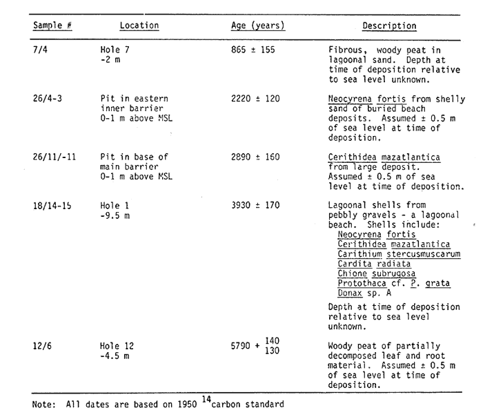 Table 1 Data for Samples Dated by 14C Method Last Stage in Rising Sea Level Sea level was 13-14 m below its present level between 6500 and 8500 years ago. The lagoonal sediments 14 m below MSL, in Hole 8 indicate that a lagoon barrier existed seaward of them at the time of their deposition. The vertical transition from lagoonal sediments at the bottom of Hole 8 to what appears to be open ocean nearshore facies indicates that as sea level rose during the Holocene, the Pacific shorezone migrated landward over older lagoonal sediments. The lack of barrier sediments may be the result of erosion during the transgression or difficulty of recognizing them in the samples. Most of the sediments supplied to this migrating shorezone came from the erosion of the shelf sands by waves and the wave-driven longshore transport of sediments from the Rio Tehuantepec. The mouth of the Rio Tehuantepec migrated landward with the shorezone and continuously supplied sediments direaly to the littoral zone. In all of the holes north of Hole 8, the sediments below the barriers are lagoonal. The deepest lagoonal sediment landward of Hole 8 is in Hole 12 at -12 m. Sea-level was at -12 m about 6200-8200 years BP according to figure 9. The continuity of the lagoonal sediments suggests that a lagoon barrier has existed seaward of Holes 2, 7, and 11 for the past 6200-8200 years. Although the leading edge of the Holocene shorezone may have migrated further inland as sea-level rose, something caused the lagoon barrier to remain seaward of Holes 2, 7 and 11. The following development of the barriers is suggested. At approximately the time it passes below where Hole 8 was drilled, the landward migrating Holocene shorezone encountered the base of the headland which forms the low hills at the base of the main barrier. The shorezone and the mouth of the Rio Tehuantepec, may have migrated farther inland as sea level rose. The sediments of the river entering the shorezone, however, had to pass around the headland stabilized the path of littoral sediment transport to the east. Anchored to this stabilized supply of sediments, the barrier built up wards on itself as the sea-level rose, widening its base and forming a ridgelike, spit-platform in the manner suggested by Meistrell (1966) and by Phleger and Ewing (1962) for coastal lagoons in Baja California. 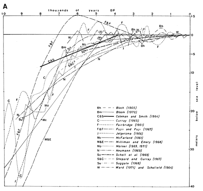 Fig. 9. Late Quaternary sealevel curves. Stabilization of Sea-Level Charts of the Tehuantepec area (Torres Lanzas, 1770; and Shufeldt, 1872), hydrologic maps prepared by the Secretaria de Recursos Hidraulicos and geomorphological evidence indicate that the Rio Tehuantepec flowed into both Laguna Superior and Mar Tileme during historical time. Climatic changes at 3600 years BP, again circa 1800 years BP, and perhaps between 1500 and 300-500 years BP, have been recognized along other parts of the Mexican coast by Curray et al (1969), Phleger and Ewing (1962), and Phleger and Ayala (1972). These investigators found evidence of increased rainfall and flooding, changes in littoral drift directions and coastal sedimentatíon rates, and relocation of river mouths which reflect significant alterations in the regional climate. In view of these findings, it seems reasonable to postulate that increased flooding during wetter climatic periods could have caused temporary diversions of the Rio Tehuantepec into the lagoons. An assemlage of shells from -9.5 m in Hole l witth an age of 3930 ± 170 years indicates that at this time there was a deep lagoon directly behind the barrier spit-platform. Back barrier channels are common in barrier lagoons. From geomorphologic evidence, it appears that as the sea level stablized, the sub-aerial barrier was a narrow spit. This "nuclear" barrier spit is designated Phase la in figure 10. The age of shells from a deposit in the base of the "nuclear" spit of the modern main barrier indicates that sea level had reached its present positien by 2800 years BP. The inner barrier is a lens of shelly sands which extends to a depth of approximately 2 m below sealevel and rests on a platform of lagoonal sediments. The configuration of the original inner barrier is represented by the dune ridge. Its curvature is such that the barrier is everywhere at right angles to the incident waves of Laguna Superior. This configuration minimizes longshore transport and suggests that the inner barrier was formed by processes acting simultaneously along its length and not by spit extension from a sedimentary source at one end. Shells from a lagoonal beach deposit on the eastern end of the inner barrier give a minimum age for this feature, Phase lb, of 2200 years BP. 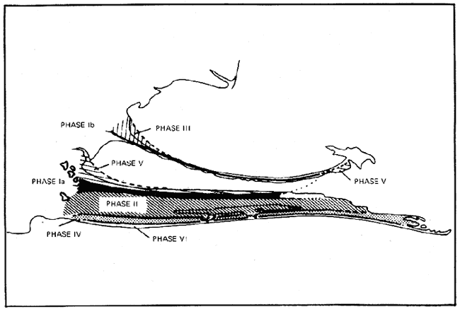 Fig. 10. Phases of Laguna Superior barrier development. After sea-level stabilization, the main barrier prograded seaward. The extent of this apparently uninterrupted progradation, Phase II, was at least 2.5 m and took between 780 and 2000 years to accomplish. This progradation was in the form of a series of parallel beach ridges accreted to the Pacific side of the main barrier. The orientation of individual ridges and swales is assumed to be representational of the shoreline orientation at the time of their formation. The low hills in the base of the main barrier were initially the headland anchor for the curved beach ridges. As the shoreline prograded seaward beyond the hills, the sediments no longer had to pass around the headland from the mouth of the Rio Tehuantepec. This is reflected in the straightening of the beach ridges south of the hills. After the formation of the inner barrier, the Rio Tehuantepec flowed into Laguna Superior forming a delta at Punta de Agua. This diversion of the river and its sediments from the Pacific coast initiated a period of erosion of the main barrier. This erosion was most effective adiacent to the mouth of the Rio Tehuantepec. The sediments of the river flowing into Laguna Superior were transported by waves to the western inner barrier, causing progradation into the lagoon, Phase III. The greatest progradation of the inner barrier occurred adjacent to the delta and was less significant to the east. This progradation was localized because of the relatively low energy available to transport the sediments away from the delta and also per haps because the Rio Tehuantepec diversion was only a brief episode. After the Rio Tehuantepec returned to its original course, erosion of Punta de Agua and the prograded beach of the western inner barrier began, leaving truncated beach ridges which are still evident at the salina. The return of the Rio Tehuantepec to its former course renewed the supply of sediments to the Pacific shorezone, and began a new period of accretion to the main barrier, Phase IV. This renewed accretion was greatest adjacent to the river mouth where the most erosion had occurred. The accretion decreased to the east, in the direction of the littoral drift, where erosion of the barrier had been less significant. The extent of Phase IV appears to have been approximately 0.47 km, and lasted 150-400 years. Based on its relation to the beach ridges of the main barrier, Laguna Quirio may have been formed during Phase IV, perhaps by a massive overwash and flooding of the beach ridges during a particularly violent storm. The orthogonal features of the main barrier appear to be abandoned and consolidated inlets. The relation of the orthogonal features of the eastern main barrier and to the beach ridges of Phases II and IV suggests that the extension eastward of the main barrier by spit extension and inlet migration may be correlated to the progradational phases of the barrier. 865 Years BP to the Present The age of the peat in the lagoonal sediments of Hole 7 is evidence that significant progradation along the lagoon side of the "nuclear" spit of the main barrier had not occurred prior to 864 ±155 years BP. Torres (1580) in a letter to the King of Spain, describes the Tehuantepec region and the Rio Tehuantepec in detail, stating that in 1580 the river flowed south from Tehuantepec into the sea. Charts produced by Spanish coastal pilots and engineers (Torres Lanzas, 1770) indicate that in 1770, the Rio Tehuantepec flowed into Mar Tileme (Fig. 11). The mouth of the Rio Tehuantepec is an unmistakable feature. It seems doubtful that the coastal cartographers having explored the lagoons and noted other, less obvious, coastal features on the charts, could have mistaken the location of the river mouth. The expedition of the U. S. Navy (Shufeldt, 1872) indicated on their chart (Fig. 12) that in 1870, the Rio Tehuantepec once againflowed into the Pacific Ocean.  Fig. 11. Copy of Spanish Chart of Tehuantepec Circa 1580. It appears that between 200 and 400 years BP, the Rio Tehuantepec flowed into Mar Tileme, and its sediments filled the lagoon basin and initiated a period of accretion and lagoon ward progradation along the northern shore of the main barrier, Phase V in figure 10. This progradation occurred along the whole length of Mar Tileme and was not restricted to progradation of its beaches immediately adjacent to the mouth of the river as was true of the inner barrier during Phase III. The greater lateral extent of progradation during Phase V was a result of the eastward component of sediment transport supplied by currents generated by the Rio Tehuantepec flowing into narrow Mar Tileme. There may have been a stable dune ridge, similar to that of the inner barrier, on the "nuclear" spit of the main barrier. The rapidly prograded lagoonal beach would have been a source of sediments not previously available which initiated lagoonward progradation of this dune ridge and the formation of the wide northern dune ridge of the main barrier. Before they became stabúzed by vegetation, the prevailing north winds extended these dunes to the south, creating tails across the main barrier and subduing the east-west ridge and swale topography. After the supply of sediments to the main barrier was reduced, these dunes were stabilized by grasses and trees whose roots reworked the upper sediments, destroying the crossbedding and developing a distinct soil horizon. Subsequently, deflation of the dunes by the north winds occurred. This deflation is presently best developed and most concentrated north of San Mateo with elongate blowout dunes breaching the wide dune ridge in many places. Because of their proximity to San Mateo, the development of the blowouts is felt to be related Sheep and goats were introduced to the Tehuantepec area in the late l6th. century (Tosto overgrazing by herds of sheep and goats. cano, 1968), but probably reached the barriers somewhat later. Sediments from the Rio Tehuantepec were carried by currents and waves beyond Mar Tileme and deposited in Laguna Inferior as well. 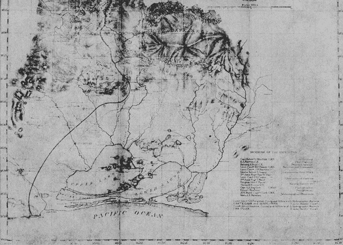 Fig. 12. U.S. Navy Chart of Tehuantepec Circa 1872. The fan-shaped swamp bordering the small bay at the eastern end of the interior barrier appears to have been formed recently, possibly from the sediments transported from Mar Tileme and deposited here through a combination of widening of the mouth of Mar Tileme, headland sheltering, and exposure to oceanic tides and wind-waves. In 1770, the inner barrier of the compound spit in eastern Laguna Inferior did not exist. By 1870, the inner barrier had formed and had enclosed the two small lagoons and the mouth of the Rio Ostuta. Its formation is almost certaínly the result of the pulse of sediments carried eastward from Mar Tileme by wave action in Laguna Inferior. Between 100 and 200 years BP, the Rio Tehuantepec returned to its original course into The Pacific. Since then the mouth of the Rio Tehuantepec has been filled in and the main barrier has prograded approximately 0.23 km, Phase VI. Although the Benito Juarez dam has cut off the supply of river sediments since 1950, erosion of the river mouth and main barrier has not occurred and progradation appears to have continued aided perhaps by sediments from the tailings of the dredging of Salina Cruz. This rate of progradation is 1.2-3 m year. This rate was used to extrapolate backwards, to date Phases II and IV. The seaward progradation of the main barrier took 1000-2500 years. This time span includes the two known periods of river diversion and may include other periods of river diversion after Phase II obscured by the more extensive diversion of Phases III and V. AgradecimientosACKNOWLEDGEMENTSThis investigation was supported by funds from the Scripps, Institution of Oceanography and a grant from the Foundation for Ocean Research. It was supervised by Fred B. Phleger and Joseph R. Curray. The author is especially indebted to Agustin Ayala-Castañares Director of the Institute of Marine Sciences and Limnology of the Universidad Nacional Autónoma de México, whose invaluable cooperation made this research possible. In addition, Carlos Márquez Mayaudon, Director, and Antonio García-Cubas of the Instituto de Biología of UNAM were extremely helpful in the logistics of this research. In the field the author was ably assisted by Perry J. S. Crampton and Frans J. Emmel of Scripps, and especially by Luis A. Sanchez Barreda. The cooperation of Manuel García jurado, Port Captain of Salina Cruz, and of Salvador Musalem of juchitán is appreciated. Petróleo Mexicano, S. A. generously made available one of their helicopters for overflights of the lagoons and for samplíng remote areas. Kenneth W. Bruland of Scripps performed the Pb-210 dating of sediment samples. Elizabeth A. Baker of Scripps helped in the identification of molluscs. LITERATURABAGNOLD, R. A., The Physics of Blown Sand and Desert Dunes,Wm. Morrow and Co., New York,1942,265 pages. BRUNN, Per, Jour. of Waterways and Harbor Division, A. S. C. E., Proc., (WWI).Sea level rise as a cause of shore erosion,1962,88 CÁRDENAS, F. M., Lagunas Costeras, un Simposio,Pesquerías de las Lagunas Litorales de México, (in Spanish) .México City1967,645-652 ---,Lagunas Costeras, un Simposio, Lagoons and mangrove vegetation,Mexico City1967,505-514. CONSULTORES EN ENGENIERA FLUVIOMARITIMA, S. A., Estudios Topohidrográficos en las Lagunas Superior e Inferior Oaxaca; for the Sec. de Marina.1970, CROMWELL, JOHN E., ThesisProcesses, Sediments, and History of Laguna Superior, Oaxaca, México; Ph. D.University of CaliforniaSan Diego.1974. CURRAY, JOSEPH R., Marine sediments, geosynclines, and orogeny, .In: Petroleum and Global Tectonics; S. Judson and A. J. Fisch, editors,Princeton Univ. Press,Princeton, N. J1974 CURRAY, J. R., F. J. EMMEL and P. J. S. CRAMPTON, Lagunas Costeras un Simposio, Holocene history of a strand plain, lagoonal coast, Nayarit Mexico,Mexico City1969,63-100. Dirección General de Pesca e Industrias Conexas, Estudios para el Aprovechamiento Pesquero de las Lagunas Superior e Inferior de Oaxaca,Publ. of the Secretaria de Industria y Comercio. FOLK, ROBERT L., Petrology of Sedimentary Rocks,Hemphill's Univ. Station,Austin, Texas,1968,170 pages. GADOW, HANS, Through Southern, Mexico,Witherby and Co.,London,1908,527 pages. GINSBURE., R. N. and H. A. LOWENSTAM, Jour. of Geology,The influence of marine bottom communitíes on the depositional environment of sediments,1958,310-318.66(3): GOLDMAN, JOEL, C., KENNETH R. TENORE and HELEN I. STANLEY,Science, Inorganic nitrogen removal from wastewater: effect on phytoplankton growth in coastal marine waters,1973,955-956.180 GROEN, P., Lagunas Costeras, un Simposio,Physical hydrology of coastal lagoons,Mexico City.1969, GUILCHER, ANDRE, Coastal and Submarine Morphology, Methuen and Co., Ltd.,Trans. by B. W. Sparks and R. H. W. Kneese.London,1958, GUNTER, G., Fisheries in coastal lagoons, Lagunas Costeras, un Simposio, Mexico City1967,663-670. HAURWITZ, B., The slope of lake surfaces under variable wind stresses,Beach Erosion Board Tech. Mem.,1951,25. HOYT, JOHN H. and VERNON J. HENRY, JR., Significance of inlet sedimentation in the recognition of ancient barrier islands,Wyoming Geological Association, Guidebook, 19 th Field Conf.;1965,190-194. INMAN, D. L. Report on beach study in the vicinity of Mugu Lagoon, California, Tech. Memorandum no. 14, Beach Erosion Board, Corps of Engineers.1950, KING, CUCHLAINE A. M., Beaches and Coasts,Edward Arnold, Publisher Ltd.,London.1959, KOIDE, MINORU, KENNETH W. BRULAND and EDWARD D. GOLDBERG, Geochimica et Cosmochimica Acta,Th-228/Th-232 and Pb-210 geochronologies in marine and lake sediments,1973,1171-118737 KOIDE, M., A. SOUTAR, and E. D. GOLBERG, Earth and Planetary Science Letters, Marine Geochronology with 2l0pb1972,442-446.14 MEISTRELL, FRANK, J., The spit-platform concept: Laboratory observation of spit development, A thesis for Master Degree, Univ. of Alberta, Edmonton, 1966. Published in Spits and Bars, M. Schwartz, editor, Dowden, Hutchinson and Ross.1972. MELTON, FRANK A., Jour. of Geology, A tentative classification of sand dunes: its application to dune history in the southern high plains,1940,113-174.48 NEUMANN, A. C., C. D. GEBELEIN and T. P. SCOFFIN, Jour. of Sed. Petr., The composition structure and erodability of subtidal mats, Abaco, Bahamas.1970,274-297.40 PARKER, R. H. Jour. of Paleontology, Changes in the invertebrate fauna, apparently attributable to salinity changes in the bays of central Texas.1955,193-211.29 PARKER, ROBERT H., In: Recent Sediments, Northwest Gulf of Mexico, Ecology and distributioal patterns of marine micro-invertebrates, Northern Gulf of Mexico, A. A. P. G., Tulsa, F. Shepard, F. Phleger and T. van Andel, editors,1960,302-337. PHLEGER, FRED B., Symposium of the Colston Research Society,Sedimentology of Guerrero Negro Lagoon, Baja California, Mexico. Colston papers, v. XVII, Proc. of the XVIIUniv. of Bristol,1965,205-237. PHLEGER, FRED B. and AGUSTÍN AYALA-CASTAÑARES, Ann Inst. Biol. Univ. Nal. Auton. Mexico, Ser. Ciencias del Mar y Limnol.,Ecology and development of two coastal lagoons in northwest Mexico,1972,1-20.1 PHLEGER, F. B. and G. C. EWING, G. S. A. Bull.Sedimentology and oceanography of coastal lagoons in Baja California, Mexico,1962,145-181.73(2): POSTMA, H., Lagunas Costeras, un Simposio,Chemistry of coastal lagoons,Mexico City:1967,421-430. PSUTY, NORBERT P., The geomorphology of beach ridges in Tabasco, Mexico, Tech. Rept. 30, Louisiana State Univ. Coastal Studies Inst.1966,51 p. REDFIELD, ALFRED C., Ontogeny of a salt marsh estuary, Science,1965,50-55.147: REX, ROBERT W., Geology of the Arctic,Hydrodynamic analysis of circulation and orientation of lakes in northern Alaska,Univ. of Toronto Press:1961,1021-1043. RHYTHER, J. H., In: The Sea,Geographic variations in productivity, Ch. 17, v. 11, M. N. Hill, editor, John Wiley and Sons, New York:1966,347-380. RHYTHER, J. H. and W. M. DUNSTAN, Science,Nitrogen, Phosphorous, and Eutrophication in the Coastal Marine Environment,1971,1008-1013.171 RIEHL, HERBERT, Tropical Meteorology.,McGrawHill Book Co.,NewYork.1954, RODEN, G. I., Geofisica Internacional, Wind driven circulation in the Gulf of Tehuantepec and the effect on surface temperatures,1961.55-76.1(3):, SÁNCHEZ-BARREDA, Luis A.,Professional thesis, Transporte de sedimentos a lo largo de la parte interna de una barra, en el complejo de las Lagunas Superior e Inferior de Oaxaca, México,Univ. Autonoma de Baja Calif.,Ensenada, B. C.México1972, SCHWARTZ, MAURICE L., Jour. of Geol., The Bruun theory of sea level rise as a cause of shore erosion,196776-92.75 SCOFFIN, TERENCE P., Jour. al Sedimentary Petrology,The trapping and binding of subtidal carbonate sediments by marine vegetation in Bimini Lagoon, Bahamas,1970,249-273.40 SHEPARD, FRANCIS P., In: Recent Sediments, Northwestern Gulf of Mexico, Gulf coast barriers. A.A.P.G., Tulsa:F. Shepard, F. Phleger and T. van Andel, editors,1960,197-220. SHEPARD, FRANCIS P., Submarine Geology, Harper and Row, New York.1963, SHEPARD, F. P. and D. G. MOORE, In: Recent Sediments Northwestern Gulf of Mexico Bays of central Texas coast, A.A.P.G., Tulsa F. Shepard, F. Phleger, and T. van Andel, editors,1960, SHUFELDT, ROBERT W.,Reports on explorations and surveys to ascertain the practicability of a shipcanal between the Atlantic and Pacific Oceans by the way of the Isthmus of Tehuantepec. U. S. Govt. Printing Office,Wash. D. C.1872, SIEDLER, GEROLD, In: Hot Brines and Recent Heavy Metal Deposits in the Red Sea, General circulation of water masses in the Red Sea, Degens and Ross, editors, Springer-Verlag, New York:1969,131-137. Tablas de Predicción de Mareas: Puertos del Oceano Pacifico;Apendice I, Parte B, de los Anales del Instituto de Geofisica, UNAM, 1971, (1970); 1973 (1972).16, 18 TAIT, ROBERT J., Jour. of Geophys. Res., Wave set-up on coral reefs,1972,2207-2211.77(12): TAMAYO, J. L. Geografia General de Mexico, Talleres Graficos de la Nación,Mexico,1949,583 pages.2 vols., TAYLOR, WILLIAM P., Landlord and Peasant in Colonial Oaxaca,Stanford University Press.1972, TORRES DE LAGUNAS, JUAN DE., In: Revista Mexicana de Estudios Antropológicos (1928), Sociedad Mexicana de Antropología,Descripción de Tecoantepeque su provincia con todas sus cabeceras y pueblos de los sujetos que en la nueva España de las yndias del mar oceano, lo cual se hace por instrucción y mandado de su majestad,Sociedad Mexicana de Antropología,1580,165-175.(2): TORRES-LANZAS, PEDRO, Relación descriptiva de los mapas y planos de México y Floridas existentes en el archivo general de Indias por Pedro Torres Lanzas, jefe de dicho archivo; Imp. de El Mercantil, San EloySevilla,1770,16.Tomos I y II,1900, TOSCANO, ALAJANDRA MORENO,Geografía económica de México (Siglo XVI) El Colegio de México.Mexico.1968, U. S. Hydrographic Office,Hydrographic OfficeSailing directions for the west coast of Mexico and Central America; the United States to Colombia including the Gulfs of California and Panama. Publ. No. 26 (formerly Publ. No. 84). U. S. Govt. Printing Office (Washington)9th edition,1951, VON ARX, W. S., The circulation systems of Bikini and Rongelap Lagoons,EOS Trans., AGU,1918,p. 861.29 WIEGEL, ROBERT L., Oceanographical Engineering,Prentice-Hall, Inc. Englewood, Cliffs, N. J.,1964,532 p.
|