|
ENVIRONMENTAL BEHAVIOR OF TERMINOS LAGOON ECOLOGICAL SYSTEM, CAMPECHE,
MEXICO
Trabajo presentado en el Simposio Internacional IXTOC-I
México, D. F., 2-5 de junio de 1982. Recibido el 2 de agosto de 1982 y
aceptado para su publicación el 22 de noviembre de 1982.
ALEJANDRO YAÑEZ-ARANCIBIA
ANA LAURA LARA-DOMÍGUEZ
DOMINGO FLORES HERNÁNDEZ
Universidad Nacional
Autónoma de México, Instituto de Ciencias del Mar y
Limnología, Laboratorio de Ictiología y Ecología
Estuarina.
PIERRE CHAVANCE
Station Marine d'Endoume, Rue Batterie des Lions
13007, Marseille, France. Contribución 298 del Instituto de Ciencias del
Mar y Limnología, UNAM. Proyecto UNAM-PEMEX/PCEESC y Proyecto
UNAM-CONACYT, PCMABEU-005322.
Los resultados describen
los procesos y componentes importantes que determinan las relaciones de
funcionalidad de la dinámica del ecosistema, sintetizando diferente
información ambiental del área. La discusión conduce al
conocimiento del funcionamiento natural aproximado del sistema,
describiéndose los habitats de probables impactos ambientales, ayudando
en el desarrollo del procedimiento de mitigación y alternativas para
minimizar el daño ambiental. El área tiene un pulso estacional
moderado de temperatura y luz y la laguna presenta un fuerte gradiente
semipermanente físico-químico, y alta diversidad de
hábitats estuárinos. Principalmente los vientos prevalecientes y
secundariamente las corrientes litorales y la descarga de los ríos,
causan un flujo neto de entrada en la boca este (Puerto Real) y un flujo neto
de salida por la boca del este (El Carmen), lo cual crea condiciones de
elevadas salinidades y sedimentos arenosos en la porción noreste de la
laguna. La mayor descarga de los ríos se localiza en la parte oeste de
la laguna creando condiciones de aguas turbias ricas en nutrientes con bajas
salinidades. Un delta de sedimentos calcáreos se forma hacia la laguna
en la boca este y un delta de sedimentos terrígenos se presenta hacia el
mar en la boca oeste. Se caracterizaron cuantitativamente cinco subsistemas
hábitats delimitados por el análisis de "cluster", los cuales
persisten en los tres periodos climáticos: estación de secas,
estación de lluvias y estación de nortes. La calidad del agua de
la laguna se mantiene por el flujo neto derivado del viento y a la
dinámica hidrológica de la boca este.
Results
describe the processes and important components which determine working
relationships of the ecosystem's dynamics; environmental information we have on
the area is synthesized. By means of discussion we reach comprehension of how
the systems naturally function. Habitats which are likely to influence the
environment and help in the development of migration and other methods to
minimize environmental damages are described. The Lagoon presents a moderate
seasonal pulse of temperature and light; and the area has a high semi-permanent
physical-chemical gradient as well as a high diversity of estuarine habitats.
Prevailing winds, littoral currents and the discharge of rivers cause a net
entrance flow at the cast inlet (Puerto Real) and a net outlet flow through the
west inlet (El Carmen), the latter creating elevated salinity conditions and
sandy sediments towards the northeast of the Lagoon. Major river discharges has
been found towards the west of the Lagoon, creating conditions of turbid waters
rich in nutrients and with a low salinity. An inner delta of calcareous
sediments formed at the eastern inlet of the Lagoon and another one of
terrigenous sediments formed towards the sea at the western inlet. Five
subsystems or habitats delimited through cluster analysis could be
characterized which keep their shape during all three climatic seasons: dry
season, rainy season and "norte" wind season. Water quality of the Lagoon is
maintained bv the net flow derived from the wind and the hydrologic dynamics of
the eastern inlet.
The lagoons and estuaries which form part of the coastal zone occupy a large percentage of the Mexican coastline (Lankford, 1977). These geomorphological and hydrodynamical unique environments are very important for the country, since they represent a cultural and economical inheritance of important consequence for the future socialeconomical development of the littoral states. Because of their environmental complexity, high productivity, ecological stability, fragility and multiple natural boundaries, these ecological coastal systems are subject of study of a great variety of scientific fields. The physical processes control the ecology of coastal lagoons and estuaries, as well as the biological processes of communities (Yáñez-Arancibia and Day, 1982). Interdisciplinary ecological understanding of these areas based upon conceptual models (diagramatical, mathematical and computational) is most important to establish proper criteria for the evaluation of uses and resources as well as to administer properly the coastal zone. This allows us to obtain systematized information: 1) to detect the changes produced both by the natural evolution of the ecological system and by pollution; 2) to evaluate the potential of resources; and 3) to get information enabling us to predict and to enforce environmental decisions for the use, and resource administration of the coastal zone (Yáñez-Arancibia, 1982). Terminos Lagoon is the most important lagoon system of the southern Gulf of Mexico. It is being intensively studied because of 1) its high diversity in species and habitats; 2) its fish molluscs and crustaceans resources; 3) its interrelations with Campeche Sound (the most important fishing area in the Gulf of Mexico) ; 4) the great industrial development (oil industry) and the general coastal development that is taking place in the lagoon and adjacent areas; 5) because it has not yet reached critical levels of pollution. It is, furthermore, of high priority to integrate all available ecological information allowing its codification into numerical models of description and qualitative interpretation of lagoon dynamics. This study aims to contribute to these proposals and should be considered complementary to the studies of Graham et al. (1981), who established the first mathematical model on circulation of the lagoon, and of Yáñez-Arancibia and Day (1982) who characterized it ecologically. The principal goal of this study is to describe, to analyze and to discuss the environmental behavior of the lagoon in terms of diurnal cycles (24-h) and seasonal cycles (monthly). By interpreting ecologically the environmental system we find an explanation for the behavioral pattern of fish communities, mechanisms of their productivity and the relations of organism exchange between the lagoon-estuarine system and the sea. BACKGROUNDThe information that exists on Terminos Lagoon is abundant and can be found in publications as well as in technical reports and dissertations. With the aim, however, to present an integration of its environmental behavior, works have been chosen that permit to integrate the results of this study and that are already published so as to allow the reader to have access to them. Yáñez Correa (1963) described in detail the sediments and sedimentary environment of the lagoon, being supported by complementary studies on bathymetry, salinity and temperature; he characterized environments of deposit and highlighted the organic processes thas are an important sediment producer in the lagoon. Ayala-Castañares (1963) discussed the benthic foraminifera ecology of the lagoon establishine that their distribution is controlled through salinity, calcium carbonate, and submerged vegetation; he determined as well the presence of recent foraminifera biofacies in the area. Phleger and Ayala-Castañares (1971) established the first hypothesis on circulation of Terminos Lagoon, based upon the distribution of salinity values, kinds of sediments and their distribution, foraminifera biofacies, and water turbidity. A complete study on the physical geography of the Terminos Lagoon area has been accomplished by Coll de Hurtado (1975) who highlighted the meteorologic, climatic and hydrogralipic processes and the important role that play meteorological processes in the morphology of the area; he urged as well to plan the utilization of resources with respect to those processes. An interpretative synthesis on Terminos Lagoon and the Campeche Sound is established by GierloffEmden (1977), based on an analysis of remote sensing; the geomorphology, water masses, and currents are the principal elements used by the author for this descriptive synthesis that strengthens the hypothesis posed by Phleger and Ayala-Castañares (1971). Botello (1978) backed up this hypothesis, too, basing his study on salinity measurements, temperature, oxygen, pH and nutrients; he realized these measurements in Terminos Lagoon during contrasting climatic seasons. Bravo-Núñez and Yáñez-Arancibia's (1979) detailed description of the area is related to the ecology of Puerto Real Inlet from a climatical, geomorphological, sedimentological and hydrological point of view which also includes the aquatic and semiaquatic vegetation., they correlate the environmental dynamic with the structure of fish communities. Amezcua Linares and Yáñez-Arancibia (1980) studied the ecology of fluvio-lagoon systems by describing in detail the area from a geomrphological, sedimentological and hydrological viewpoint which includes as well vegetation. They correlated the environmental dynamic with fish communities and oyster reefs and proposed that these systems export energy towards Campeche Sound. Mancilla Peraza and Vargas Flores (1980) accomplished the first studies on circulation and the net flow of water through Terminos Lagoon that depend on the wind regime, littoral circulation, tides, and volume of river flow. These data can be considered to be the first quantitative information on water transport of the lagoon. For the first time, Yáñez-Arancibia et al. (1980) defined the habitats of Terminos Lagoon by establishing a quantitative correlation of ecological affinity in-between the different environments of the lagoon, fish population assemblages and their migrations. Graham et al. (1981) proposed the first mathematical model of circulation of Terminos Lagoon by utilizing the numerical model CAFE-1 comparing it both with the results of the Mancilla Peraza and Vargas Flores study (1981) and with satellite photographies of the earth (Landsat). It was established that the wind is the principal process that operates and controls circulation of the lagoon which reveals the necessity to maintain hydrologic capacity of Puerto Real Inlet to guarantee water quality inside the lagoon. Vargas Maldonado et al. (1981) studied the ecology of the inner littoral of Carmen Island describing in detail the area and emphasizing on mangrove assemblages and seagrass, environmental dynamics about fish communities and the definition of the habitat has been related by them. Yáñez-Arancibia et al. (1982 a) established the environmental behavior of Puerto Real Inlet, during annual cycles and variations of 24-hrs; they considered parameters such as salinity, temperature, transparency and tides and correlated the dynamics of this subsystem to the diurnal and seasonal dynamic of fish communities. Primary productivity of Terminos Lagoon has been studied by Day et al. (1982) who took into account the sea grass, mangroves, phytoplankton, and chlorophyllous pigment and found a high correlation with the environmental dynamic related to salinity, turbidity and nutrient concentration. Finally, Yáñez-Arancibia and Day (1982) presented the first ecological characterization of Terminos Lagoon; they synthesized the actual state of knowledge on the resources of the lagoon, described the fragile areas with respect to the environmental impact and identified necessities for investigation. Among the principal conclusions of this study, they described the correlation between physical and biological processes in this area, characterized the gradients, of environmental parameters and gave preliminary results of habitat gradients.
The intensive research over
the past nine years on ecology of systems and the evaluation of fish
communities, have resulted in publications of numerous technical scientific
reports of limited distribution and restricted circulation. Those documents
originated from the following investigation projects: "Ecological studies on
Terminos Lagoon, Campeche, México, with special reference to fishery
resources and to the potential influence of man", UNAM/CONACYT/PCMABEIT-005322,
and "Comparative analysis of fish populations at Terminos Lagoon and Campeche
Sound, prior and after the oil spill of IXTOC-I well",
UNAM/PCEESC/PEMEX/150580-010982. Project developed at the LIEF
LIEE:
Laboratory of Ichthyology and Estuarine Ecology.
During our research effort, we have relied heavily on interpretation of remote image scences obtained from: NASA, Gemini 5, Mission No. S 65-45-765, August 22, 1965; NASA Skylab 2, Mission No. SL 204-307, August 1973, NASA Landsat 2, January 16, 1978; NASA Landsat 2, February 1979; NASA Landsat 2, October 8, 1979. With these data some aspects of the environmental behavior of the lagoon have been confirmed. GENERAL ASPECTS OF THE AREATerminos Lagoon is situated in the southern Gulf of Mexico off Campeche Sound (Fig. 1). It is a shallow and broad area with a mean depth of 3.5 m and a surface of 2500 km². The lagoon is connected to the sea by two inlets and there is a strong water flow towards the western part caused by predominantly eastern winds, the littoral current and the discharge of rivers. Due to this circulation pattern a semipermanent gradient of salinity, turbidity, nutrient levell different kinds of sediments, associations of foraminifera and macrobenthos, and shrimp and fish migrations were found. There exists a great diversity of estuarine environments (subsystems or habitats), which include brackish mangrove marshes of low salinity, seagrass, grassland, areas of high sedimentation, oyster reefs and the central oligohaline basin (Fig. 1). Two different sources of sediments exist in the lagoon: fluvial sediments and calcareous sediments originating in beaches of the eastern part of the lagoon. Nutrient chemistry in the lagoon is determined by circulation, river flow, and biology of the estuarine complex. Salinity and fluvial discharge are the factors that control phosphorus and oxydized forms of the inorganic nitrogen during the rainy season. During the dry season concentration of inorganic compounds seems to be correlated to the local conditions such as turbulence, kind of sediments, reducing rate and biological activity. 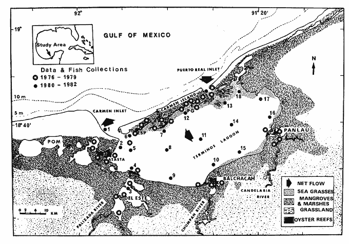 Fig. 1. Terminos Lagoon, Mexico. Sampling stations prior to (between 1976 and 1979) and after (between 1980-1981) the oil spill of IXTOC-I well. Principal habitats of the ecological lagoon-estuarine system are shown. Productivity of mangroves as well. as phyto plankton are higher in areas of fluvial in fluence. During the rainy season, oxygen super saturation in some areas indicates a net production. Terminos Lagoon and adjacent areas are situated in a tropical zone and do therefore not show a high seasonal variability pattern. Yáñez-Arancibia and Day (1982), however, sup, est three climatic periods related with the precipitation, river discharge, wind frequency, and environmental temperature (Fig. 2). Those climatic seasons would be: dry season: February to May; rainy season with precipitation during afternoons and nights from June to October; and the "nortes" season from October-November until February, when there may be occasional rains. Annual precipitation ranges from 1 100 to 2 000 mm. The fluvial discharge into the lagoon reflects the precipitation as it is shown in the annual discharge pattern of Candelaria and Usumacinta rivers (Fig. 2). Mean total discharge has been estimated at 6 X 1 09M3 /year (Phleger and Ayala-Castañares 1971). The southwestern part of the lagoon gets more than 50% of the fresh water supply. Two different wind systems occur (Fig. 2) during the months of October until February, winds blow from the NW (segmetns 11 and 12, Fig. 2) ; while during the remaining year light breezes occur with winds from the NNE (segment 1, Fig. 2) and ESE (sco-Ment 4, Fig. 2). MATERIAL AND METHODSFrom February 1980 until April 1981 we sampled monthly in a network of 18 stations which cover the entire area of Terminos Lagoon (Fig. 1) Furthermore, two nichthemeral cycles (24-hrs) carried out twice a month during one year at the Puerto Real Inlet (from August 1980 until July 1981), as well as at the Estero Pargo Inlet (from February 1981 until January 1982 have been realized). At each sampling station, upper water salinity and bottom salinity were measured, as well as upper water and bottom water temperature. The light penetration has been estimated by means of a Secchi disk used as a measuring unit with a sounding line. Finally, the kind of sediment, submerged and surrounding vegetation, and the prevailing environmental conditions have been observed. 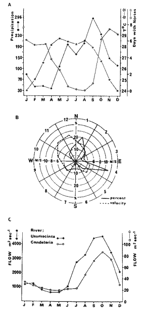 Fig. 2. Climatic relations in the area of the Terminos Lagoon. A. Seasonal variations of environmental temperature, "nortes" (stormy winds), and precipitation. B. Wind direction and speed. C. River discharges m3sec-1. Salinity, temperature, and transparency out of the measured abiotic parameters, are being affected by the climatic and meteorological changes such as tides, currents, winds, precipitation, and river discharges. The climatic-meteorological pattern taken into account is the one proposed by Yáñez-Arancibia and Day (1982). Mean water transparency has been estimated and related to the depth according to the following formula: T= t/p x100 in which T represents the percentage of transparency, light penetration into the water column, and p depth during each event. During the nichthemeral cycles at Puerto Real Inlet and off Estero Pargo Inlet, only surface salinity and temperature measurements were carried out. However, at the network of the 18 stations, measurements of average surface and bottom salinity and temperature were taken and utilized for the following analysis. Stations were assembled (from the collection of 18 stations) by taking into account their respective positions, which reflects a geographical similarity, and their marine or fresh water influence which characterized some of the habitats or subsystems. Values of February, March, and April 1980 and 1981 were averaged, in order to study the environmental behavior during in annual cycle. To know the variations of salinity, temperature, and water transparency, their average was calculated and their mean spreading or of coefficient variation expressed mathematically by: in which Cv represents the coefficient of variation S the standard deviation and x the average of each parameter in regard to: a) sampling stations during the annual cycle, and b) each month at the 18 stations, finding in this way both 1) specific zone within the lagoon and 2) climatic season within the annual cycle. To know he variations of sanity, temperature, and water transparency, their mean spreading or of coefficient variation expressed mathematically by: in which Cv represent the coefficient of variation S the standar deviation an x the average of each parameter in regard to: a) sampling stations during the annual cycle, and b) each month at the 18 stations, finding in this way both 1) specific zone within the lagoon and 2) climatic season within the annual cycle.  The complete analysis of environmental parameters and sampling stations was carried out by means of a computer program based on the principles of cluster analysis (Davies, 1971) which consists of assemblages stations based on the presence or absence of environmental characteristics. Thus, the different values for each parameter represent an individual and each station a character. The presence of an individual in each station takes a value of 2 and its absence a value of 1. The amount of same characteristics shared between two stations showed the similarity gradient between both of them, which takes values from 0 (no individual in common) to 1 (all individuals in common) when each station is compared individually. This procedure is repeated by comparing one station to the other until all stations have been compared. Once all coefficients were calculated, the average linkage assembling (Sneath and Sokal, 1979) was used, which is a modification of Davies' single linkage (1971). This linkage is based on the calculation of a mean similarity between an individual or group with another. Results are shown in dendrograms of stations versus environmental parameters. Those programs with some variations have been utilized by Horn and Allen (1976), Warburton (1978), Chávez (1979), Daniels (1979), Yáñez-Arancibia et al. (1980), Sánchez-Gil et al. (1981), and Vargas Maldonado et al. (1981) to delimit subsystem or habitats based upon ecological affinity of fish populations and their correlation with the physical parameter. RESULTS
FLUVIO-LAGOON SYSTEMSCharacterization of the habitat. Various important rivers discharge their waters into Terminos Lagoon (Fig. 1). The Candelaria river at the northwestern tip is one of the most important supply source; its basin is situated principally in the Yucatan Peninsula. It has been calculated that the supply of this river with its affluents reaches 21.5 m³sec-¹. This river together with the Mamantel river supply, form the Panlau Lagoon ' which connects the Terminos Lagoon to the Pargos Inlet. This unit forms the Candelaria-Panlau System. The Chumpan river develops in the coastal plain through Salsipuedes and San Joaquin rivers and flows finally into the Balchacah Lagoon situated at the southern tip of Terminos Lagoon. Annual volume of draining reaches 1 368 millions Of m3. River and lagoon form the Chumpan-Balchacah System. The Palizada River forms part of the hydrological system of Mexcalapa, Grijalva and Usumacinta rivers. Branches of this river, together with other smaller rivers give origin to interior lagoons: to the east originate the Vapor, Este and San Francisco Lagoons which, together consists the Palizada-del Este System, and to the west the Pom-Atasta System with various annexed lagoons. It is considered the Candelaria, Chumpan and Palizada rivers together have a minimum discharge of 6 X 10 9 m³ year. Generally, the 4 fluvio-lagoon systems have ranges that oscillate between brackish water (25%o) to almost fresh water (2%o), varying those ranges according to the wet season and to the specific site of these systems, since a gradient can be recognized from the highest portions to the outlet of the system into Terminos Lagoon (Amezcua Linares and Yáñez-Arancibia, 1980). The coastal vegetation that emerges at the margins of the fluvio-lagoon systems, tidelands, channels, and small lagoons is mostly covered by mangroves. In some of the inlets of the fluvio-lagoon systems, as e.g. Candelaria-Panlau, submerged vegetation is principally formed by large Thalassia testudinum beds while towards the system's interior Ruppia maritima were found. Also, large parts are covered by the macroalgae Phaeophyceae like Gracilaria sp and other types grow where those systems are connected with Terminos Lagoon. Calla lily, Eichornia crassipes, cover large extensions toward the higher portion of the Palizada-del Este System. Rush marsh fields (Typha sp), as well as fields of reeds (Phragmites) can be found in those systems, being most abundant in the Palizada-del Este System. Other types of vegetation submerged in waters with low salinity values are Vallisneria americana, Myriophylum exalbescens and Potamogeton illinoensis. The sediment in the fluvio-lagoon systems is silty-clay with less than 25% of CaCO3. The most notable characteristic of these systems is the presence of oyster reefs found at the mouths of the 4 fluviolagoon systems; thus, at inlets those zones are very shallow and only at the outlets of rivers and channels water reaches depths of 2 m. Hydrology. Lowest salinity values in the lagoon are found at zones directly affected by the fluvio-lagoon systems discharge; this phenomenon is more evident in the SW portion (Fig. 3). Since Terminos Lagoon is directly affected by the discharges, salinity values were measured during the annual cycle 1980-1981 at stations 4 9, 10, 15 and 16 (Fig. 3), those values oscillated between 5 ppt and 32 ppt (Table 1). The mean salinity value for these 5 stations showed its maximum (28.6 ppt) during the dry-wet season (June) and its minimum (9.2 ppt) during the rainy-"nortes" season (November). It is important to outline that at station 3, situated within the Palizada-del Este System, the recorded salinity values almost reach a fresh water range of (0 to 2 ppt), thus this station has been considered as a control station. Station 4, off the inlet of this same fluvio-lagoon system, showed lower salinity values than those of other stations. Amezcua Linares, and Yáñez-Arancibia (1980) reported for this system a salinity range of 2 to 14 ppt and they classified it as a fluvio-lagoon system where fresh water predominates. Salinity parameters showed to be highly influenced by the season since during the rainy season and the season of "nortes" the variation coefficient is higher than during the dry season (Table 1) where stations strongly affected by the fluvio-lagoon systems present a certain stability. Temperature showed values between 20 and 32°C and mean values were very similar no the salnity pattern with top values in June (30.9°C), dry-rainy season and lowest ones in January (21.8°C), "norte" wind season (Table 1 and Fig. 3). Generally, values of coefficient of variation are low throughout the year, i.e. from 1.4 to 9.8% which indicates that temperature variations for the 5 stations are minimum, thus showing a similar monthly pattern. Amezcua Linares and Yáñez-Arancibia (1980) found that for 4 fluvio-lagoon systems, temperature ranges from 20 to WC during the dry season and from 26 to 32°C during the wet season. Transparency, unlike the previously analyzed parameters, does not show a seasonal pattern reaching 100% at station 16 during February. Yáñez Correa (1963) situates this station in an environment with relatively uniform deposit conditions. The lowest value, 12%, is registered in October at station 9 which is highly influenced by discharges from the Chumpan Balchacah System and the one of Palizada del Este (Table 1). Mean transparency values were 24% in October and 62% in February (Table 1, Fig. 3). Amezcua Linares and Yáñez-Arancibia (1980) reported a transparency of 20 and 40%. The coefficient of variation shows that the transparency fluctuates highly in each of the 5 stations during one month and it seems likely that this parameter is being influenced by the characteristic meteorologic phenomenons of the area (Table 1 and Fig. 3). 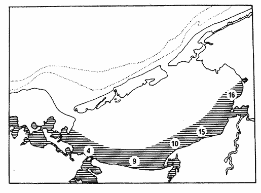 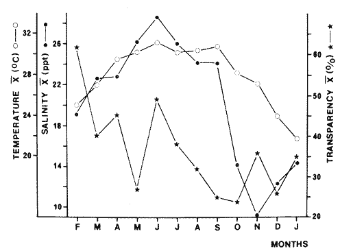 Fig. 3. Map showing the sampling stations directly affected by the discharge of the Fluvio-Lagoon System. The graph corresponds to monthly values of collecting stations: temperature, salinity, and transparency for the annual cycle (1980-1981). Highest salinity and temperature values occur in June. 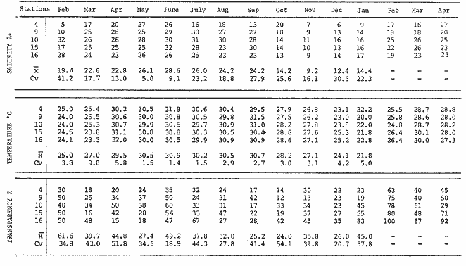 TABLE 1 AVERAGE OF SALINITY, TEMPERATURE AND TRANSPARENCY (SURFACE AND BOTTOM) VALUES FOR STATIONS THAT FORM THE FLUVIO-LAGOON SYSTEMS OF TERMINOS LAGOON. PERIOD 1980-1981 CENTRAL BASINCharacterization of the habitat. The central portion of Términos Lagoon is generally considered to be an area of transition in-between the marine conditions of the northeastern section and the brackish sections of the southern and western parts. Botello's (1978) salinity data show the presence of a marine gradient in the waters coming from the Gulf of Mexico and penetrating into the lagoon through Puerto Real Inlet; those waters mix with fresh water from the 4 big rivers, thus originating a water mass of low salinity which once more discharges into the Gulf of Mexico through Carmen Inlet at the western portion of the lagoon. The characteristic vegetation of the Central Basin consists of macroalgae in clear waters which are found towards the east and in more turbid waters towards the west. Algae species Gracilaria sp predominate. The center of the lagoon has a large and shallow area with a depth of 4 m that decreases towards the oriental littoral where bottoms of 0.3 m occur. Sediments are distributed in structural units, thus forming an almost tidy arrangement; sediments consist principally of silty and clay sands, which gradually mix with a zone of sand, silt and clay. This arrangement of structural graduation is, however, strongly altered by the sediment sources, topography of the bottom and water circulation. The currents produced by winds are more efficient in the sediment transport of the lagoon's middle portion, than the water currents that enter through the inlets of the estuaries. The transportation by the residual flow of rivers, together with the currents gradually produced by winds from SE and NW, obviously carries a great quantity of sediments towards the lagoon's central part. The major part of the central lagoon sediments contains almost 50%, of CaCO3 (Yáñez Correa, 1963). Hydrology. This transition zone made up by stations 8, 11, 14, and 17 (Table 2, Fig. 4) presented during the period 1980 to 1981 have salinity values between 10 ppt and 36 ppt. Mean values show a seasonal pattern, since the lowest ones (14.7 ppt) occured during the rainy"nortes" season indicating that during that time a major fluvial discharge occurs. Salinity starts to rise in January and reaches its peak value (30.5 ppt) in June during the dry-rainy season. Botello (1978) reports on values of 33 to 35 ppt, found in the central basin during the dry season, while the rains water salinity decreases to 20 to 25 ppt because of the rains and the fresh water supply. Values of the coefficient of variation compared with salinity, fluctuated between 6.68 and 21.13% which indicates that there is little spreading of values in the 4 sampling stations analysed; thus, this zone can be considered as a stable subsystem with seasonal variations. Generally, temperature did not show important variations at each station: it fluctuated between 21 and 31°C (Table 2). The behavior of the mean temperature (Table 2, Fig. 4) shows a similar pattern than the one of salinity, being lowest in January (22°C) and highest in June (30.4°C). Botello (1978) reports on an uniform temperature pattern during the dry season with a slight stratification and observes a decrease during the rainy season which is reflected by the conditions that prevail during this period. Values of the coefficient of variation is kept low throughout the year; which reveals that the 4 considered stations within the central basin present a similar behavior during the whole annual cycle (Table 2). Transparency showed values from 10 to 100% (Table 2). Mean values did not indicate a seasonal pattern (Fig. 4), fluctuating from 24.3% (August) to 62.5% in February. The coefficient of variation showed values between 18.2 and 58.7% which means that spreading of transparency values is very high in each of the stations which are, on the other hand, influenced by the different phenomenons that affect this parameter, as for example, the winds. 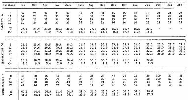 TABLE 2 AVERAGE OF SALINITY, TEMPERATURE AND TRANSPARENCY (SURFACE AND BOTTOM) VALUES FOR STATIONS THAT FORM THE CENTRAL BASIN OF TERMINOS LAGOON. PERIOD 1980-1981 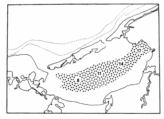  Fig. 4. Map showing sampling stations in the Central Basin of Terminos Lagoon. The graph corresponds to monthly values obtained in the differente collecting station: temperature, salinity, and transparency for the annual cycle 1980-1981. Highest salinity and temperature values occur in June. INNER LITTORAL OF CARMEN ISLANDCharacterization of the habitat. The northern portion of Terminos Lagoon, next to Carmen Island, presents a persistent marine influence, maintaining elevated salinity and trans parency values. It is important to outline that there is no inflow of fresh water to Carmen Island; therefore, the only fresh water supply is provided by rains during the rainy and "nortes" season. The principal zones of seagrass of the lagoon extend in the inner littoral of Carmen Island, Puerto Real Inlet and Bajos de Sabancuy. The immersed vegetation is composed of seagrass, where Thalassia testudinum dominates; macroalgae (Phaeophycea and Rhodophycea), large mangrove fields (principally Rhizophora mangle), and some. palm groves grow as well. This vegetation is being associated with high salinity values, transparency and the calcium carbonate content. A narrow strip of sandy, marine sediments is found along Carmen Island, which are possibly deposited by the currents that hold a east-west direction. The eastern part of the island's inner littoral is situated in an area of biogenic accumulation, and the zone of Bajos del Cayo seems to have been the delta of an old inlet. There exists a high organic content and CaCO3 in proportions of 40 to 50% (Yáñez Correa, 1963). Vargas. Maldonado et al. (1981), Yáñez-Arancibia et al. (1981 a), and Yáñez-Arancibia. and Day (1982) reviewed the existing bibliography on hydrological, geomorphological, and biological aspects of the area. Hydrology. The general salinity behavior throughout the annual cycle showed a seasonal pattern (Fig. 5) that increases from 28.7 ppt (in February) to 34.7 ppt (in June) when it reaches its highest values. Then, in November, it decreases to its lowest value (14.9 ppt) but increases one more during December and January. The average value was of 27.7 ppt with a coefficient of variation of 24.8% (Table 3). Temperature values oscillated from 21.8°C in January to 30.8°C in June with a mean value of 27.8°C and a variation coefficient of 10.7% (Table 3, Fig. 5). Transparency does not seem to have a. regular pattern throughout the year. It showed values from 33.2% in December up to 63.4% in June, with an average of 51.2% and a coefficient of variation of 25.5%. However, there exists a clear trend of increase from March/April until June; then it decreases until December. During September the highest values were recorded (83.4%), revealing an exception in this general tendency (Table 3, Fig. 5). The three environmental parameters showed generally a similar seasonal pattern. Their fluctuations are related to the characteristical climatic changes of each season. Highest values could be recorded during the end of the dry season when the rainy season starts and precipitation is reduced as well as the rivers discharges. Consequently, the system keeps stable. During the rainy season a major marine water dilution is produced, as well as an increase in turbidity due to the supply of organic material and particles in suspensions provided by the rivers, which causes an important decrease in salinity, temperature, and transparency. This decrease reaches its minimum value during the "nortes" season when the before mentioned phenomenon intensify; winds from the north intensify in speed as well, and influence the circulation pattern and the hydrological regime of the lagoon. However, there exists a discordance in the minimum values of salinity, transparency and temperature that shows up in November, December, and January, respectively (Table 3, Fig. 5). In cycles of 24 hours, realized at Estero Pargo Inlet throughout one year, salinity reaches its lowest values during night, between 18 h and 6 o'clock in the morning, while highest values could be registered during hours of highest insolation, i.e. from noon to 4 p.m. These values were measured during the months of February, Mach, July and September (Table 4, Fig. 6). In May, salinity remained almost the same and did not present a deifned pattern related to the time of the day during November and January, since highest salinity values were registered during hours without light which could have been caused by the tides (Table 4, Fig. 6).   Fig. 5. Map showing sampling stations in the Inner Littoral of Carmen Island. The graph corresponds to monthly values obtained in the different collecting stations: temperature, salinity, and transparency for the annual cycle (1981-1981). Highest salinity and temperature values occur in June.  TABLE 3 AVERAGE OF SALINITY, TEMPERATURE AND TRANSPARENCY (SURFACE AND BOTTOM) VALUES FOR STATIONS THAT FORM THE INNER LITTORAL OF CARMEN ISLAND AT THE TERMINOS LAGOON. PERIOD 1980-1981 Temperature showed a similar pattern to what was described earlier, since lowest values occurred during the night and the first hours of the day (from midnight to 10 a.m.). Also, highest temperature values occurred during hours of major insolation and the first hours of the night (noon to 8 p.m.) (Table 4, Fig. 6). Salinity and temperature ranges for this annual nichthemeral cycle from 10 to 36 ppt (November at 6 a.m.; may-almost all day) and in February 22°C at 4 a.m. and 31.6°C at 4 p.m. during September (Table 4). Mean values of salinity for each month fluctuated in between 13.79 ppt in November and 35.93 ppt in May (Table 4, Fig. 7). An increase is observed during the dry season from February until May where it reaches its top value, and during the wet season (July to October) salinity starts to decrease until reaching its minimum value in November. An obvious seasonal pattern can be noted for this parameter. Mean temperature registered throughout the year oscillated between 24.87 and 30.30°C in February and September, respectively, showing as well slight variations. The minimum value was registered in winter but increased constantly until reaching its top value in summer. This parameter exhibited a seasonal cycle within a very narrow range (Table 4, Fig. 7). PUERTO REAL INLETCharacterization of the habitat. Towards the cast, Terminos Lagoon is connected with Campeche Sound through the Puerto Real Inlet. This inlet is considered to be predominantly a marine area due to the net flow of the Gulf of Mexico waters toward the lagoon, also becaused there is little fresh water influence. Thus, highest values of salinity are recorded, distributed particularly in the oriental portion of the lagoon with variable boundaries according to the different climatic periods. 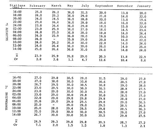 TABLE 4 ENVIRONMENTAL PARAMETERS OFF ESTERO PARGO INLET. 24 HOURS CYCLES The emergent coastal vegetation in this area is composed of platns that grow in beaches, mangroves situated inward and of coconut plantations. The submerged vegetation is represented by Thalassia testudinum beds, Halodule grigtti, Syringodium filiforme and macroalgae (Phaeophyceae and Rhodophyceae). A typical characteristic of Puerto Real Inlet is the flood tide delta which lies towards the interior of the lagoon with a principal circulation channel towards the cast. Yáñez Correa (1963) considers this inlet to be a sedimentation environment where littoral currents displace material -principally of marine origin close to the coastline. There the tide current movement and the geomorphology of the area help so that a major portion of sediments in being shifted towards the lagoon's interior and another portion is being deposited at the beach by wave action. Sediments include thick material and fine -grained fragments, as well as no- clastic and organic material. Fifty to 70% of calcium carbonate is shown. Existing literature on hydrological, geomorphological and biological aspects of Puerto Real Inlet was reviewed by Bravo-Núñez and Yáñez-Arancibia (1979) and Yañez-Arancibia et al. (1982 a). Hydrology. The Puerto Real Inlet is principally being influenced by the inflow of Gulf of Mexico marine waters and by the draining of local fresh water. Salinity records, along the annual cycle, fluctuated between 40 ppt (june 5, 1981 at noon) and 22 ppt (December 6, 1980 at 10 a.m.) and an average value of 34.3 ppt (Table 5, Fig. 8). Three times. (October and December 1980 and July 1981) the decreasing salinity was associated with the tide flow of the Gulf and reflected, probably, the movement of low salinity waters of the adjacent shelf. In the southern Gulf of Mexico tides are principally diurnal and only occasionally semidiurnal whereas in the tropics and ecuator, semidiurnal tides occtir in a stretch of time of aproximately 8 days. 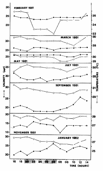 Fig. 6. Temporal and nichthemeral distribution (24 hrs.) of salinity and temperature at Estero Pargo Inlet. Selected hours and months are indicated. Lowest salinity and temperature values occur during night and highest values during hours of high insolation. Tidal patterns are modified by various meteorological phenomena, especially by the wind. During the "nortes" season, the period of tides is affected by the duration of the ebb, the reflux being reduced and prolonged. The opposite is true when winds blow from a southernly direction. In Puerto Real Inlet sampling was done during diurnal tides, and lowest tide ranges were registered in February and April 1981, when winds blow predominantly from the north. Water temperature ranged from 33.5°C (August 11, 1980 at 2 p.m.) to 23.8°C (December 7, 1980 at 6 a.m.) with a mean value of 28.4°C (Table 5, Fig. 8). The seasonal salinity pattern is strongly correlated to the temperature pattern (Fig. 9). Lowest values have been recorded in December during the "nortes" season with a salinity of 30.5 ppt and temperature of 24.4°C, while highest values occurred in june at the end of the dry season, with salinity values of 37.0 ppt and temperature of 31.2°C (Table 5). The transparency also exhibits the same seasonal pattern with mean values lower (27%) in December after the major fluvial discharge period and the highest value (100%) during June and July at the end of the dry season and beginning of the rainy season (Table 5, Fig. 9). EL CARMEN INLETCharacterization of the habitat. The El Carmen Inlet is situated at the west of Terminos Lagoon. It is a zone which is influenced by fresh water from the adjacent fluvio-lagoon systems; it is influenced as well by Gulf of Mexico marine waters and lagoon brackish water. Mancilla Peraza and Vargas Flores (1980) and Graham et al. (1981) point out the existence of a net flow of sea water that enters through Puerto Real Inlet and discharges into the sea through EI Carmen Inlet. Because of that, its hydrological regime presents variale characteris tics which also depend on the time of the year, even though estuarine conditions due to the mixture of water prevail. During the rainy season, fresh water conditions stand out, but during the dry season sea water prevails. 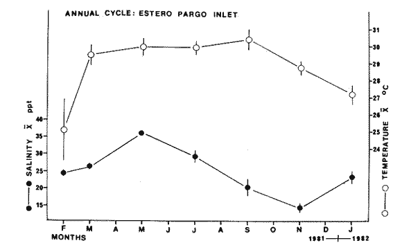 Fig. 7. Seasonal variation of salinity and temperature at Estero Pargo Inlet during the annual cycle 1981-1982. Average and standard deviations per month are illustrated. Highest temperature values were present from March to September; the lowest value in February. Highest salinity occurred in May and the lowest salinity in November. The submerged vegetation is composed of macroalgae remainders and of occasionaly floating vegetation such as Calle lily (Eichhornia crassipes). On the surrounding banks, vegetation is being represented by few consolidated mangroves (Yáñez-Arancibia et al. (1981 a). The topography and sedimentation pattern are strongly affected by the currents (Yáñez Correa 1963). A channel of almost 13.5 m leading to the sea is localized in the area, as well as a sedimentation delta in the exterior part of the lagoon on the internal continental shelf. The western portion of El Carmen Inlet is predominantly influenced by river outlets. Generally, the sediments of these areas are of a sandy-clay-silty grain, and some terrigenous materials are observed with abundant organic material as a final no-clastic component. The percentage of CaCO3 varies in-between 20 to 30%. Towards the eastern side lies the recently formed submarine delta of the open sea; and in the principal channel abundant gravel and sands are found (constituted principally by shells of mollusks and rests of them). In the secondary channels which are filled with less rapid waters, silt and clay are quite abundant; silt is even more abundant at the edges of the delta. Sediments of this delta have not been studied well up to this day. In this portion of El Carmen Inlet, CaCO3 content is present from 10 to 20%. Hydrology. Throughout the year cycle (1980-1981) at the El Carmen Inlet, salinity registers fluctuated between 6.8 ppt in November and 31.3 ppt in June 1980, with a mean value of 21.2 ppt and a coefficient of variation of 38.90-1 (Table 6, Fig. 10). Temperature values oscillated from 22.1°C in January 1981 to 30.9°C in June 1980 with a mean value of 27.3°C and a coefficient of variation of 11.0% (Table 6, Fig. 10). Transparency reached its lowest value (14.3%) in November and the highest (31.7%) in June 1980, with a mean value of 24.2% and a variation coefficient of 24.2 (Table 6, Fig. 10) . 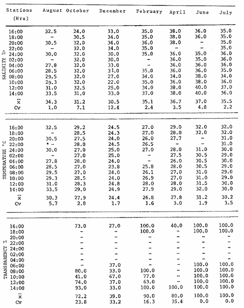 TABLE 5 ENVIRONMENTAL PARAMETERS AT PUERTO REAL INLET. 24 HOUR CYCLES 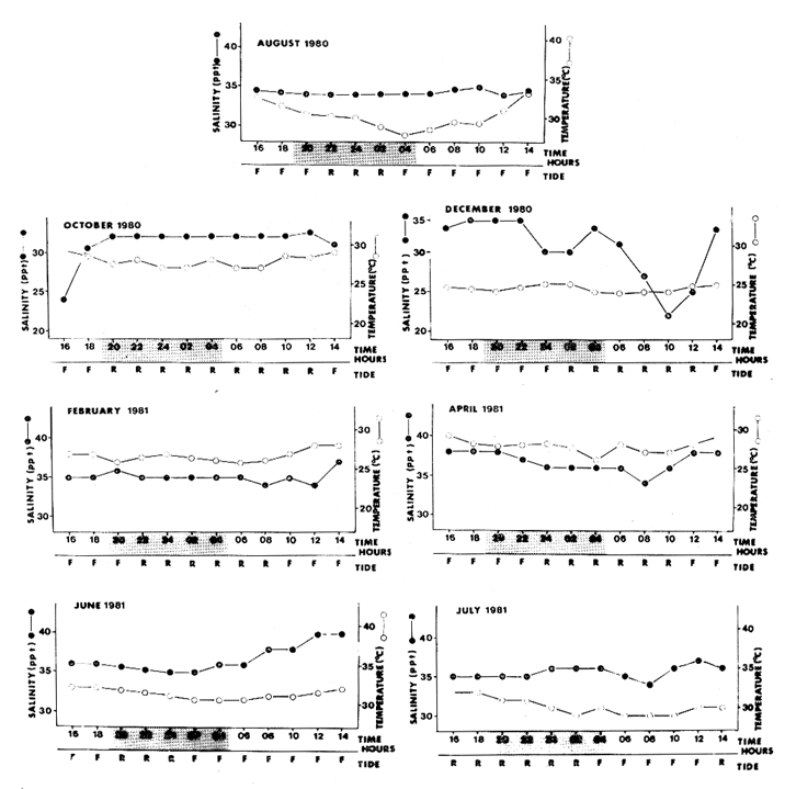 Fig. 8. Temporal and nichthemeral distribution (24 hrs.) of salinity and temperature in Puerto Real Inlet. Selected months, time and state of tide (R = ebb, F = flow) are indcated. Lowest temperature and salinity values occur in December and highest ones from june to August. 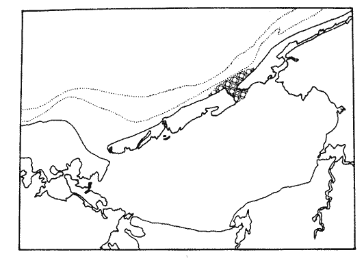 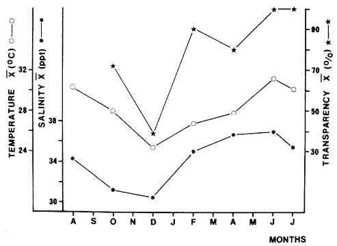 Fig. 9. Map showing Puerto Real Inlet in Terminos Lagoon. The graph corresponds to the measurements of salinity, temperature, and transparency performed twicea month. Lowest values of these parameters occurred in December while the highest ones in june. 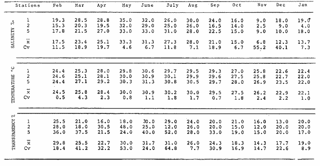 TABLE 6 AVERAGE OF SALINITY, TEMPERATURE AND TRANSPARENCY SURFACE AND BOTTOM) VALUES FOR STATIONS THAT FORM THE EL CARMEN INLET AT TERMINOS LAGOON. PERIOD 1980-1981 The behavior of the parameters shows a very similar seasonal pattern which are directly influenced by the climatic changes of each season (Yáñez-Arancibia and Day, 1982), since highest values occur at the end of the dry season and starting the rainy season, when marine conditions are prevailing and precipitation and river discharges is reduced. Lowest values are exhibited during the "nortes" season when discharges of rivers are elevated and the zone is being affected by intermittent torrential rains and strong northern winds. All these have a direct bearing on the circulation pattern of the lagoon and on the hydrological conditions at El Carmen Inlet.   Fig. 10. Map showing the sampling stations at El Carmen In let. The graph corresponds to monthly values of temperature, salinity and transparency for a year cycle (1980-1981) measured at the collecting stations. In june highest values of salinity and temperature were recorded. DISCUSSION AND CONCLUSIONThe variations of salinity and transparency averages compared with their coefficient of variation of for each sampling station show an association of stations, the position of which varies according to the climaticmeteorologic season (Fig. 11 to 16). The graphs reflect, however, a geographical similarity which allows groups of ecologically similar stations to form. The analysis of figures 11 to 16 preliminarily defines for the lagoon a scheme of following subsystems; the inner littoral of Carmen Island and northwestern portion (Group 1); the Central Basin (Group II); the fluvio-lagoon systems and areas of immediate influence (Group III, III2); and the El Carmen Inlet (Group IV). The Puerto Real Inlet shows a different behavior than the one of these subsystems. Figure 17 recapitulates the annual balance. The salinity behavior of each station and for the dry season revealed a strong marine influence (Fig. 11) where the inner littoral of Carmen Island (I) and the Central Basin (II) are closely related. Together with the oriental portion of the fluvio-lagoon systems (III1) they form one group which shows, when observed on a map, an elevated stability in a broad lagoon area. The western portion of the fluviolaeoon system (III2) and the EI Carmen Inlet (IV) form another, but a less stable group since it is situated in an area of greater fresh water influence. As it can be observed in the graph (Fig. 12), the lagoon ecosystem presents on increase in its stability during the rainy season; at the same time the assemblage of the inner littoral of Carmen Island (I), Central Basin (II) and the oriental portion of the fluvio-lagoon systems (III1) is maintained. During this climatic period, El Carmen Inlet joins this assemblages. Because of the high fresh water discharge that gets the western portion, of the fluviolagoon systems (III2) an elevated variation is presented. A change occurs in the lagoon during the "nortes" season, principally caused by northern winds and the higher fluvial discharge volume; a saline gradient can he observed now (Fig. 13) which causes the assembling of the Central Basin (II) with the fluvio-lagoon systems (III, and III2) and part of the inner littoral of Carmen Island (I). The remaining stations that form Group I separate and another group is originated at Puerto Real Inlet, a zone which is highly marine influenced. Stations 1 (Carmen Inlet) and 17 (next to Puerto Real Inlet) present an intermediate portion where the inflow of marine water into the lagoon occurs in both inlets; this inflow is caused by northern winds and has a strong correlation with the pattern of sediments in suspension shown on satellite photographs by Yáñez-Arancibia and Day (1982, Fig. 4, rainy season; Fig. 5 "nortes" period, and Fig. 6, dry season). During the dry season Terminos Lagoon generally presents an elevated transparency (Fig. 14) associated with the submerged vegetation (Thalassia testudinum and macroalgae) principally distributed in the inner littoral of Carmen Island, the Basin (II) and the oriental portion of the fluvio-lagoon systems (III,). Transparency decreases towards the western portion of the lagoon and the lowest records have been measured at the Carmen Inlet (IV) and the western portion of the fluvio-lagoon systems (III2). Transparency shows a notable gradient during the rainy season (Fig. 15) with the highest values be measured to wards the Puerto Real Inlet, the inner littoral of Carmen Island (I) and the eastern part of the fluvio-lagoon systems (III2). Once again those values are associated with the distribution of Thalassia testudinum. In this climatic period, the Central Basin (II) presents similar transpaorency values as EI Carmen Inlet (IV) and the western part of the fluvio-lagoon systems (III2). During the "nortes" season (Fig. 16), highest transparency values could be observed at the inner littoral of Carmen Island (I), as well as towards the Puerto Real Inlet, Central Basin (II) and eastern portion of the fluviolagoon systems (III2) ; the latter mentioned group showed a better stability in its transparency behavior during this climatic period (Fig. 16). The lowest transparency values occured towards the western part in the lagoon and a gradient could be observed from the Central Basin to the Carmen Inlet where highest values of turbidness were recorded.   Fig. 11. The map shows the distribution of salinity at Terminos Lagoon in the sampling stations during the dry season. The graph relates the averages of salinity and their respective coefficient of variation for the sampling stations and the same climatic period. 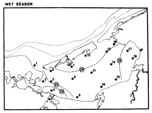 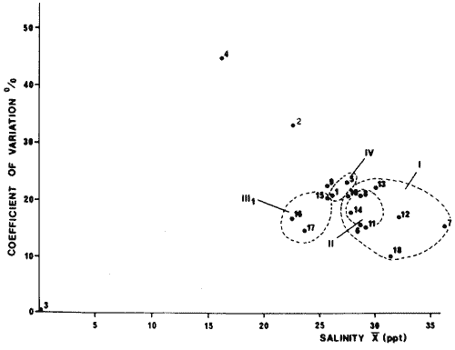 Fig. 12. The map shows the distribution of salinity at Terminos Lagoon in the sampling stations during the rainy season. The graph relates the averages of salinity and their respective coefficient of variation for the sampling stations and the same climatic period. 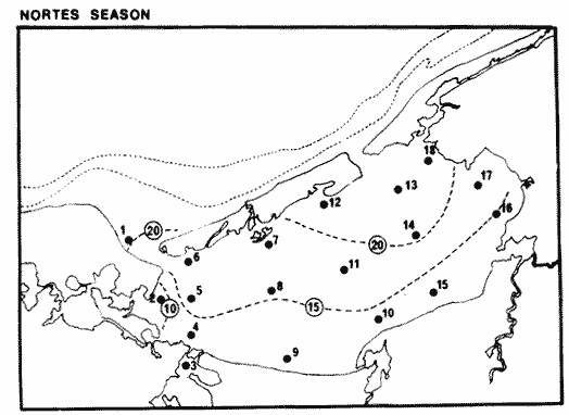 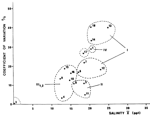 Fig. 13. The map shows the distribution of salinity at Terminos Lagoon in the sampling stations during the "nortes" season. The graph relates the averages of salinity and their respective coefficient of variation for the sampling stations and the same climatic period. 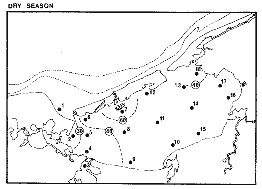 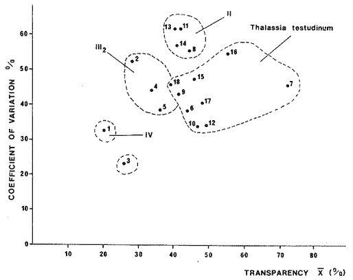 Fig. 14. The map shows the distribution of transparency at Terminos Lagoon in the sampling stations during the dry season. The graph relates the averages of transparency and their respective coefficient of variation for the sampling stations and the same climatic period. 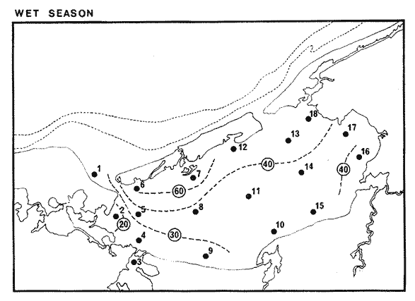 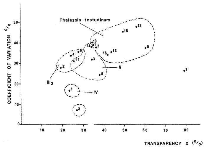 Fig. 15. The map shows the distribution of transparency at Terminos Lagoon in the sampling stations during the rainy season. The graph relates the averages of transparency and their respective coefficient of variation for the sampling stations and the same climatic period.   Fig. 16. The map shows the distribution of transparency at Terminos Lagoon in the sampling stations during the "nortes" season. The graph relates the averages of transparency and their respective coefficient of variation for the sampling stations and the same climatic period. The most elevated transparency at Terminos Lagoon (Fig. 14 and 16) is generally associated to the presence of submerged vegetation distributed at the inner littoral of El Carmen Island, and the eastern part of the Central Basin and fluvio-lagoon systems. Medium values could be recorded towards the west of the Central Basin during the rainy and "nortes" season (Figs. 15 and 16), as well as at the western part of the fluvio-lagoon systems and El Carmen Inlet throughout the year (Figs. 14 to 16). The Puerto Real Inlet has a great contrast with the Carmen Inlet. As shown in satellite images by Yáñez-Arancibia, and Day (1982), the transparency behavior presents a notable correlation with the sedimentation pattern (Fig. 4, rainy season; Fig. 5, "nortes" season and Fig. 6, dry season). By means of this first approach to a simplified model of lagoon's reality, it can be said that habitats persist throughout the year but their boundary vary due to the physical control of the seasonal parameters. Both parameters do not depend on the biological activity of the system, but salinity control diversity, distribution, and abundance of different biotic groups. Transparency (indirect measuremetn of sediments in suspension) directly measures the percentage of penetration of light into the water column both, the effect of light penetration and sedimentation control the metabolic activities of the system and the settlement of biotic communities (phyto and zoobenthic). The quantitative analysis of the general behavior of the system, the salinity, temperature and transparency show that only the first two present an obvious seasonal pattern; transparency does show a seasonal pattern too, even if it is less regular (Fig. 18). This seems reasonable since those parameters vary with more or less influence of environmental factors for example: winds, tides and river discharges. Transparency has a less obvious pattern since the quick changes of the energy level in the water column appear to determine the spacial and temporal distribution of transparency. Values of figure 18 are averages for each month; salinity oscillated between 12 ppt in November ("nortes") and 29 ppt in june (end of dry season) which resembles the behavior that showed each of the previously analyzed habitats of the lagoon. The temperature varied between 21.8°C in January ("nortes" and 20.7°C in june (dry season), while the transparency was between 23.4% in March (dry season) and 67.9% in February ("nortes" season). Figure 19 shows the mean annual gradient of salinity which goes from a northeastern to a southwestern direction exhibiting the annual tendency of the water circulation pattern. There exists a direct relationship between the annual average of the gradient and the water transparency as can be seen in figure 19. Both parameters are directly related with the circulation pattern where highest salinity and transparency values go together with habitats of highest and persistent marine influence, as for example Puerto Real Inlet. In their influence area, the fluvio-lagoon systems control the lowest salinity and transparency, and constitute the areas, of elevated sedimentation. Water circulation depends on the littoral marine circulation and the river discharges, but principally on the wind regime. Figure 2 in dicates the two principal wind systems. During "nortes" and northwestern winds (segments 11 and 12, Fig. 2) the mean speed is slightly higher than 8 m sec-1. During the Test of the year a system of breezes dominate with winds that blow from a northeastern (segment 1, Fig. 2) and eastsoutheastern direction (segment 4, Fig. 2). The orientation of eastern breezes that blow from the sea inward reflects the regional influence of winds that do not generally blow from the southeast. The most evident circulation element in the lagoon is the strong net flow from east to west caused by prevailing eastern winds (Gierloff-Emden, 1977; Mancilla Peraza and Vargas-Flores, 1980; Graham et al., 1981). Figure 20 is a diagram model of speed and direction averages of currents during the two wind regimes and illustrates the two physical processes. Graham et al. (1981) indicate a maximum flow in inlets of approx, 6 000 m3 sec-1. During south-southeastern winds, approximately a quarter to one-third of all water that penetrates through Puerto Real Inlet the lagoon leaves, during one tide cycle, through the same inlet towards the sea. Thus, this net transport flow is inverse in Carmen Inlet, revealing itself in the respective deltas. Also, during south-southeastern winds an oriental portion of the water body tends to remain stagnant. During "nortes" winds water penetrates the lagoon through both inlets, but by averaging the tidal cycle more water tends to leave through Puerto Real Inlet. In the inner littoral of Carmen Island water direction has a completely opposite orientation; and it is interesting to observe that this meteorological phenomenon ("nortes") causes a removal of water of the oriental portion that remained stagnant and influenced furthermore on the existence of a practically stagnant large water bag, localized in the central portion of the south-southeast, and on a countercurrent of the south-southeast portion.  Fig. 17. Variation of salinity and transparency averages throughout the 15 months of sampling related widi the coefficient of variation for each sampling station. An assemblages of ecologically related stations can be observed.  Fig. 18. Chararteristics average of transparency, temperature, and salinity during the 15 months of sampling at the 18 collecting stations indicated in figure 1. The results (Fig. 20) indicate different features: 1) a significant portion of water that enter through Puerto Real Inlet leaves the lagoon through EI Carmen Inlet; but waters that enter through EI Carmen Inlet affect only the first third part of the wetsern lagoon; 2) the fresh water tampon of the rivers generally prohibits that saline waters, which enter through EI Carmen Inlet, flow directly along the southeastern littoral of the lagoon; 3) during typical tide cycles of approximately 15 hrs (estimated annual average) marine water flows in through Puerto Real Inlet and the opposite occurs with estuarine waters in EI Carmen Inlet. Meteorologically governed, this circulation pattern determines the nature, texture and the distribution of sediments (Fig. 21). Transition sand is found in the inner littoral of Carmen Island; silty-clay sediments are distributed principally in the central and western portion of the lagoon, and the fine grained sediments, commonly clay, are found to be associated to the river discharges. 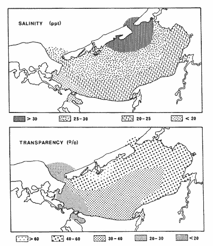 Fig. 19. Mean salinity and transparency gradient at Terminos Lagoon. Both parameters are directly related to the water circulation pattern. Major salinities and transparencies are associated to areas of higher and persistent marine influence related to Puerto Real Inlet. The environmental changes in the circulation behavior determine that the sediment types do not present a notably sedimentological gradient although CaCO3, as an important structural component of principally marine sediments, shows a gradient highly correlated to salinity, transparency, and circulation pattern during south-southeasterly winds. When Yáñez-Arancibia and Day (1982) describe the Terminos Lagoon from an ecological point of view they hipothetically proposed a high correlation in-between the physical and biological process of the ecosistem and emphasized the need of studies that should be initiated as for example: 1) the identification and quantification of ecological connections between Terminos Lagoon and fisheries; 2) the implement of and ecological-hydrological model of the lagoon; 3) the forescast of changes that may occur because of human activities and 4) the develompment of a series of conceptual model for the analysis of ecological and economical connections in Terminos Lagoon. In some aspects, this study may constitute an improvement, by further describing the environmental behavior. Five ecological habitats or subsystems can be defined which reflext interactions between physical conditions and the structure of biotic communities (Yáñez-Arancibia et al., 1981 b; Yáñez-Arancibia et al., 1982 b). Table 7 and figure 22 show the model of Terminos Lagoon habitats as consequences of the environmental behavior. Terminos Lagoon does not present a strong seasonal pulse of the temperature and the radiation that it gets; however, the area shows a strong semipermanent physical gradient of the salinity and the transparency as well as the tide influence and some sedimentological components which is a consequence of the circulation pattern controled principally by the winds. Those physical processes determine the presence and persistence of five ecological habitats or principal subsystems clearly delimited which are denominated in this work Group I to IV and Puerto Real Inlet. The statistical arrangement of some of the most significant parameters and the analysis of a computer model allow us to show quantitatively the presence of those habitats (Fig. 22). Most of the biological processes of the lagoon are strongly influenced by these gradients and they can be observed to those illustrated in figure 1 and atble 7. 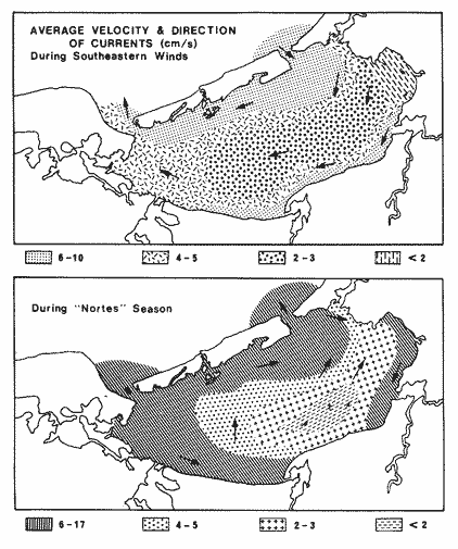 Fig. 20. Circulation model proposed by Graham et al. (1981) which indicates that during predominantly southeastern winds, a circulation from east to west in caused whith maximum speed at Puerto Real Inlet and the inner littoral of El Carmen Island. During northem winds with maximum average speed have been measured in both inlets and in yhe eastern-southeastern regions of the lagoon. Arrows indicate the direction of the currents. 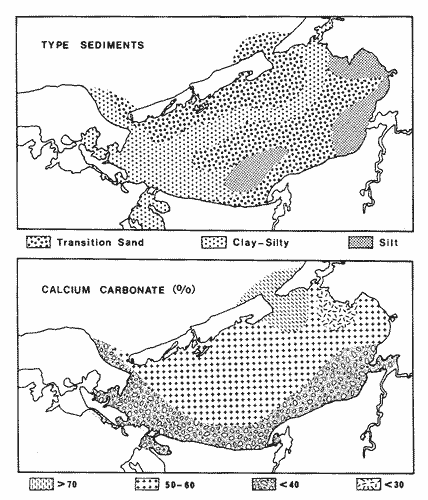 Fig. 21. Geographical distribution of the type sediments and the percentage of calcium cabonate content in sediments. (This distribution is reguled by the circulation pattern graph reproduced from Yáñez Correa, 1963). 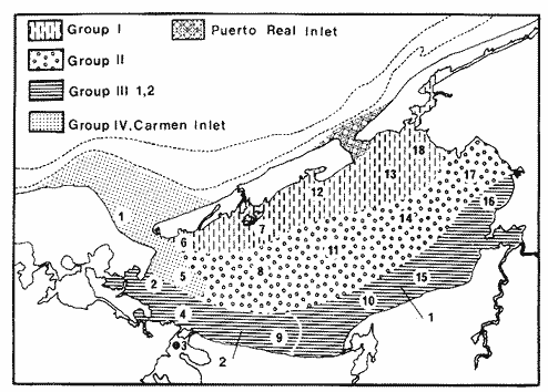 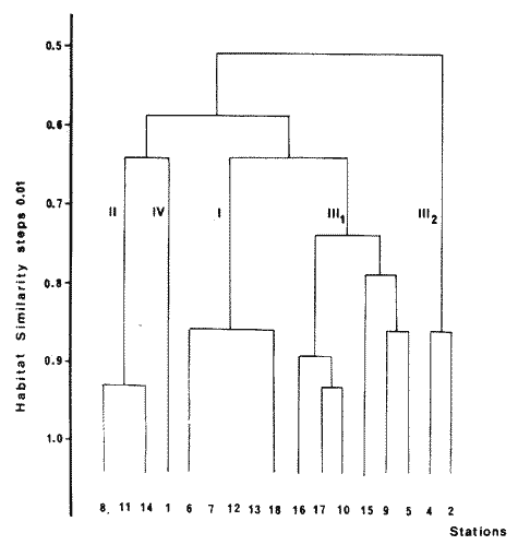 Fig. 22. This map shows the spatial and temporal distribution of the five proposed habitats or ecological subsystems for the lagoon-estuarine ecosystem of Terminos Lagoon. The environmental characteristics of the sampling stations have been considered. The graph corresponds to the quantitative dendrogram of ecological affinity of the environmental parameters, using the simple matching coefficients index of similarity and the single linkage clustering method.
TABLE 7 AgradecimientosThe institutional and financial support for the present study was provided by the Instituto de Ciencias del Mar y Limnología, Universidad Nacional Autónoma de México (ICM1,UNAM) and Secretaría de Marina, Secretaría de Pesca y Petróleos Mexicanos (PEMEX) through the Programa Coordinado de Estudios Ecológicos de la Sonda de Campeche (PCEESC). The support was also provided by the UNAM-CONACYT Project PCMABEU 005322. Special thanks to Ramiro Román Contreras and the staff of the Estación de Investigaciones Marinas "EI Carmen" for field support. The authors thank to the Laboratorio de lctiologia y Ecología Estuarina (ICML) team for encouragement, information obtaining, and field support: Hernán Álvarez. Arturo Aguirre, Margarito Tapia, Felipe Amezcua, Silvia Díaz and Margarito Álvarez. For statistical analysis of data, preparation of tables and, figures and general discussion we want knowledge to Patricia Sánchez-Gil. LITERATURAAMEZCUA LINARES, F. F. YÁÑEZ-ARANCIBIA An. Centro Cienc. Del Mar y Limnol. Ecología de los sistemas fluvio-lagunares asociados a la Laguna de Términos. El habitat y la estructura de las comunidades de peces. Univ Nal. Autón. México 1980 70-118 7 (1) AYALA-CASTAÑARES, A. Sistemática y distribución de los foraminíferos recientes de la Laguna de Términos, Campeche, México. Bol. Inst. Geol. Univ. Nal. Autón. México 1963 14-30 67 (3) BOTELLO, A. V. An. Centro Cienc. del Mar y Limnol. Variación de los parámetros hidrológicos en las épocas de sequía y lluvias (mayo y noviembre de 1974) en la Laguna de Términos, Campeche. Univ. Nal. Autón. México 1978 159-178 5 (1) BRAVO-NÚÑEZ, E. A. YÁÑEZ-ARANCIBIA An. Centro Cienc. del Mar y Limnol. Ecología en la Boca de Puerto Real, Laguna de Términos. 1. Descripción del área y análisis estructural de las comunidades de peces. Univ. Nal. Autón. México 1979 125-182 6 (1) CHÁVEZ, E. A. An. Centro Cienc. del Mar y Limnol. Análisis de la comunidad de una laguna costera de la costa Sur Occidental de México. Univ. Nal. Autón. México 1979 15-44 6 (2) COLL DE HURTADO, A. El sureste de Campeche y sus recursos naturales. Serie Cuadernos Inst. Geogr. Univ. Nal. Autón. México. 1975 85 p. DANIELS, K. Proc. Third Constal Marsh and Estuary Management Symposium. Habitat designation based on cluster analysis of Ichthvofauna. Day Tr., J. W., D. D. Culley, R. E. Turner y A. T. Murphrey Louisiana State University, Division of Countinuing Education. Baton Rouge, La. 1979 317-324 DAVIES, R. G. Computer Programming in Quantitative Biology. Academic Press. London 1971 420-430 DAY, Jr. T. W. R. H. DAY M. T. BARREIRO F. LEY-Lou CH. MADDEN Primary production in the Laguna de Términos, a tropical estuary in the Southern Gulf of Mexico. Proc. International Symposium on Coastal Lagoons. ISCOL-UNESCO'81. Bordeau France, Sept. 7-14, 1981. Oceanologica Acta. 1982 GIERLOFF-El\1DEN, H. G. Orbital Remote Sensing of Coastal and Offshore Environments: A Manual of Interpretation. Laguna de Términos and Campeche Bay, Gulf of Mexico. Berlin 1977 78-89 GRAHAM, D. S J. P. DANIELS J. M. HILL T. W. DAY, Jr. An. Inst. Cienc. del Mar y Limnol. A preliminary model of 'the circulation of Laguna de Términos, Campeche, México. Univ. Nal. Autón. México 1981 51-62 8 (1) HORN, H. M. L. G. ALLEN Bull. South. Cal. Numbers of species and faunal resemblance of marine fishes in California Bays and estuaries. Acad. Sci. 1976 159-170 75 (2) LANKFORD, R. R. Estuarine Processes, Circulation, Sediments and Transfer of Material in the Estuary. Coastal lagoons of Mexico: Their origin and classification. Wiley, M. E. Academic Press Inc. New York 1977 182-215 2 MANCILLA PERAZA, M. M. VARGAS FORES An. Centro Cienc. del Mar y Limnol. Los primeros estudios sobre la circulación y el flujo neto de agua a través de la Laguna de Términos, Campeche. Univ. Nal. Autón. México 1980 142 7 (2) PHLEGER, F. B. A. AYALA-CASTAÑARES Bull. Am. Ass. Proceses and history of Terminos Lagoon, Mexico. Petrol. Geol. 1971 2130-2140 55 (2) SÁNCHEZ-GIL F P.. A. YÁÑEZ-ARANCIBIA . AMEZCUA LINARES An. Inst. Cienc. del Mar y Limnol. Diversidad, distribución y abundancia de las especies y poblaciones de peces demersales de la Sonda de Campeche (Verano, 1978). Univ. Nal. Autón. México 1981 209-240 8 (1) SNEATH, 14. A. P. R. R. SOKAL Numerical Taxonomy: The Princibles and Practice of Numerical Classification. W. H. Freeman and Company San Francisco 1979 573 p. VARGAS MALDONADO. 1.. A. YÁÑEZ-ARANCIBIA F. AMEZCUA LINARES An. Inst. Cienc. del Mar y Limnol. Ecología y estructura de las comunidades de peces en áreas de Rhizophora mangle y Thalassia testudinum de la Isla del Carmen, Laguna de Términos. Sur del Golfo de México. Univ. Nal. Autón. Mexico 1981 241-266 8 (1) WARBURTON. K. Community structure, abundance and diversity of fish in a Mexican coastal lagoon system: Estuar. Coast. Mar. Sci. 1978 497-519 7 YÁÑEZ-ARANCIBIA, A. Usos, recursos Y ecología de la zona costera. Ciencia y Desarrollo (CONACYT) 1982 58-63 43 (VIII) YÁÑEZ-ARANCIBIA. A. and T. W. DAY, Jr. Ecological chaacterization of Terminos Lagoon a tropical lagoon-estuarine svstem in the Southern Gulf of Mexico. Proc. International Symposium on Coastal Lagoons. ISCOL-UNESCO'81. Bordeaux. France. Sept. 714. 1981. Oceanológica Acta 1982 431-440 Vol. Spec. 5 (4) YÁÑEZ-ARANCIBIA. A., F. AMEZCUA LINARES and T. W. DAY, Jr. Estuarine Perspectives. Fish community structure and function in Terminos Lagoon a tropical estuary in the Southern Gulf of Mexico. Kennedy, V. Academic Press Inc. New York 1980 465-482 YÁÑEZ-ARANCIBIA. A.. A. L. LARA-DOMÍNGUEZ, P. SÁNCHEZ-GIL, I. VARGAS MALDONADO, P. CHAVANCE, H. ÁLVAREZ GUILLÉN. F. AMEZCUA LINARES, Ma. de la C. GARCÍA ABAD, D. FLORES HERNÁNDEZ, M. ÁLVAREZ RUBIO, M. TAPIA GARCÍA, S. DÍAZ RUIZ, A. AGUIRRE LEÓN and J. L. ROJAS GALAVIZ Proyecto de Investigación Análisis Comparativo de las Poblaciones de Peces de la Sonda de Campeche y de la Laguna de Términos, antes y después del Derrame Petrolero del Pozo IXTOC-I (Tercer Informe). Las comunidades de peces y el habitat de la Laguna de Términos y de la Sonda de Campeche durante los cruceros de febrero de 1980 a abril de 1981: Comparación y Caracterización de las Interacciones Laguna-Sonda PCEESC/UNAM/ICML (TI) 1981a 466 p., 337 tablas, 49 figs. YÁÑEZ-ARANCIBIA, A., F. AMEZCUA LINARES, P. SÁNCHEZGIL, I. VARGAS MALDONADO, A. L. LARA-DOMÍNGUEZ, A. AGUIRRE LEÓN, S. DÍAZ RUIZ and P. CHAVANCE Estuary-shelf fish community interaction in the Southern Gulf of Mexico: Fishhabitat comparisons. Estuaries 1981b 295 4 (3) YAREZ-ARANCIBIA, A., A. L. LARA-DOMÍNGUEZ, P. SÁNCHEZ-GIL, I. VARGAS MALDONADO, P. CHAVANCE, F. AMEZCUA LINARES, A. AGUIRRE LEÓN and S. DIAZ RUIZ Ecosystem dynamics and nichthemeral and seasonal programming of fish community structure in a tropical estuarine inlet, México. Proc. International Symposium on Coastal Lagoons ISCOL-UNESCO'81, Bordeaux, France, Sept. 7-14, 1981. Oceanológica Acta 1982a 417-429 Vol. Spec. 5 (4) YAREZ-ARANCIBIA, A., A. L. LARA-DOMINGUEZ, P. SÁNCHEZ-GIL, I. VARGAS MALDONADO, Ma. de la C. GARCÍA ABAD, H. ÁLVAREZ GUILLÉN, M. TAPIA GARCÍA, D. FLORES HERNÁNDEz and F. AMEZCUA LINARES International Symposium on Utilization of Coastal Ecosystem: Planning, Pollution and Productivity Ecology and evaluation of fish community in, he Campeche Sound and Terminos Lagoon: Estuaryshelf interactions in the Southern Gulf of Mexico. Duke Univ. Mar. Lab. USA and Univ. de Rio Grande-R. S. Brasil. Atlántica Río Grande 1982b 130 5 (2) YÁÑEZ C0RREA, A. Batimetría, salinidad, temperatura y distribución de los sedimentos recientes en la Laguna de Términos, Campeche, México. Bol. Inst. Geol. Univ. Nal. Autón. México 1963 1-47 67 (1)
|