|
ENVIRONMENTAL, BEHAVIOR OF CAMPECHE SOUND ECOLOGICAL SYSTEM, OFF
TÉRMINOS LAGOON MÉXICO: PRELIMINARY RESULTS
Trabajo
presentado en el Simposio Internacional IXTOC-1, México, D. F., 2 al 5
de junio, 1982. Recibido el 2 de agosto de 1982 y aceptado para su
publicación el 22 de noviembre de 1982.
ALEJANDRO YÁÑEZ-ARANCIBIA
PATRICIA SÁNCHEZ-GIL
Universidad Nacional Autónoma de México, Instituto
de Ciencias del Mar y Limnología, Laboratorio de Ictiología y
Ecología Estuarina. Contribución 297 del Instituto de Ciencias
del Mar y Limnología, UNAM. Proyecto UNAM-PEMEX/PCEESC y Proyecto
UNAM-CONACYT, PCMABEU 005322.
Se sabe que en el
área de estudio, la dirección e intensidad de la
circulación costera cambian estacionalmente, así como
también se conoce que aquí se presenta el área de
transición sedimentológica entre las provincias deltaica y
carbonatada del Sur del Golfo. Interpretando ecológicamente el sistema
ambiental, se encuentra la explicación a los patrones de comportamiento
de las comunidades de peces, los mecanismos de su productividad y las
relaciones de intercambio de organismos entre el mar y los sistemas
lagunarestuarinos. Para analizar el ecosistema y delimitar hábitats, fue
utilizado el método "cluster" y pruebas estadísticas para
correlacionar diferentes parámetros ambientales reportados en la
literatura, además de las mediciones obtenidas en seis cruceros
realizados en el área (OPLAC/P-1 junio 1978 a OPLAC/P-6 marzo 1982). Los
resultados mostraron diferencias significativas para dos regiones, lo que
permite delimitar dos subsistemas ecológicos frente a la Laguna de
Términos. Zona A: heterogénea, fuertemente
influenciada por el aporte de estuarios y ríos adyacentes, con las
siguientes características: aguas turbias, transparencia de 7 a 42%,
salinidad superficial de 32.3 a 37.0%o, salinidad de
fondo de 35.6 a 37.0%o, temperatura del agua en
superficie de 22.8 a 27.7°C, en el fondo de 23.3 a 28.0°C,
sedimentos limoarcillosos con 10 a 60% de CaC03 y alto
contenido orgánico (k 10%), pH de 7.6 a 8.3, oxígeno disuelto
< 4.0 ml/l, ausencia de macrovegetación béntica. Zona
B: área típicamente marina, homogénea, con las
siguientes características: aguas claras, transparencia de 50 a 99%,
salinidad superficial y de fondo de 35.7 a 37.2%o,
temperatura del agua en superficie de 26.1 a 28.8°C, en el fondo de 24.2
a 28.1°C, sedimento arenoso con 70 a 90% de CaCO3
y bajo contenido orgánico (< 10%), pH de 7.7 a 8.9, oxígeno
disuelto > 4.0 ml/l, pastos marinos y macroalgas bénticas. Una
frontera natural abierta y de límites variables, se ubica entre ambas
zonas y en ella las características ambientales se traslapan.
It
is already known tliat in this study arca, direction and coastal circulation
intensity change seasonally; we also find here an area of sedimentological
transition between the deltaic and carbonated provinces of the southern Gulf.
The ecological interpretation of the environmental system provides an
explanation of the behavioral pattern of fish communities, mechanisms of
productivity and the relationships of organisms exchanges between the sea and
the lagoon-estuarine systems. Clustering was used to analyze the ecosystem and
to delimit habitats, while presently published statistics as weIl as the
measurements obtained from the six cruises done in the region (OPLAC/ P-1 June
1978 to OPLAC/P-6 March 1982) helped us correlate the different environmental
parameters. Results showed signifícant differences between the two
regions so as to delimit now two ecological subsystems off Terminos Lagoon.
Zone A: is heterogeneous, estuarine and riverine influenced
with the following characteristics: turbid waters, transparency 7 to 42%,
superficial salinity of 32.2 to 37.00/00, bottom. salinity of 35.6 to
37.0%o, upper water temperature of 22.8 to
27.7°C, bottom temperature of 23.3 to 28.O°C, silty clay
sediments with 10 to 60% CaC03 and high organic content
(> 10%), pH of 7.6 te 3.3 dissolved oxygen < 4.0 ml/l, absence of any
benthic macrovegetation. Zone B: is a homogeneous and
typical marine area, with the following characteristics: clear waters,
transparency 50 to 99%, superficial and bottom salinity of 24.2 to
28.1o%o, upper water temperature 26.1 to 28.8°C,
bottom temperature of 24.2 to .28.1°C, sandy sediments with 70 to 90%
CaC03 and low organic content (< 10%), pH of 7.7 to
8.9, dissolved oxygen > 4.0 ml/l, seagrass and benthic macroalgae. A natural
border, open and with variable limits, can be found between both zones, where
values of environmental parameters overlap.
The Southern Gulf of Mexico is considered a particularly important zone because of its high biotical potential and energetic resources. Campeche Sound represents one of the most intensively studied areas due to: 1) its high diversity in species; 2) heterogeneity of habitats (subsystems); 3) its relationship with Terminos Lagoon (the most important lagoon-estuarine system in Mexico); 4) the industrial expansion in the region, principally the oil industry; and 5) because it has not yet reached critical levels of pollution. In 1976, systematic studies on the environmental dynamics of Terminos Lagoon were initiated as well as studies on the structure and function of fish communities. This research is now published in numerous works, e.g. Yáñez-Arancibia et al. (1980), Yáñez-Arancibia and Day (1982), Graham et al. (1981). Studies on Campeche Sound started in 1978 with the OPLAC Program (Oceanography of Campeche Continental Shelf), and initial environmental information together with its correlation with fish communities have been proposed by Sánchez-Gil et al. (1981). The oil spill of the IXTOC-I (June 3rd 1979 to March 9, 1980) well showed the lack of information on the ecosystem dynamics and determined the necessity to intensify studies on the environmental behavior of the ecological system and its integration with biotic resources. Results of these have been obtained from the works of Yáñez-Arancibia et al. (1983) who report as well on the ecological dynamics of fish communities in Campeche Sound and Terminos Lagoon (1982a and b) where they analyze the structure and function of the system from the viewpoint of interrelationships between estuaries and continental shelf. The objectives of this present study are: 1) to complete the above mentioned studies; 2) to describe and analyze the Campeche Sound habitat dynamics; 3) to integrate all data obtained since 1978 with information of selected references; 4) to interpret, from an environmental point of view, the ecosystem, offering a synoptical atlas of its seasonal behavior. With an ecological interpretation of the system's environmental dynamics, we would undoubtedly find further answers and explanations of the behavioral patterns of biotical resource communities as well as the mechanisms of productivity as nave been analyzed by Darnell and Soniat (1979) and Walne (1972) and the relationship of physical and biological interaction between Campeche Sound and Terminos Lagoon. BACKGROUNDLimited information exists on environmental sciences of Campeche Sound. The little information we have from the Gulf of Mexico arises generally from classic works and some books. A few of them have been chosen to complete the results of our studies; but even if the ecological importance of Campeche Sound is notorious there is not systematic environmental data on this zone. Prince (1954) considering the coastal lines of the Gulf of Mexico proposes geo-oceanographical classification which, apart from being consequences of exposed geological structures, are linked to the regional geology, geomorphology, sedimentation, coastal oceanography, meteorology, climatology, biology, chemistry and ecology of some marine and coastal organisms. This geo-oceanographic classification includes both alluvial coasts where the deltaic region of Tabasco-Campeche lies and where the carbonated coastal shelf lies on the calcareous region of Campeche-Yucatan, the latter being influenced by biogenic activity. The knowledge of the Gulf of Mexico started with historical geology (Lynch, 1954) because of the necessity to obtain new out1ooks and to explore new petroleum provinces, as weIl as for obtaining oceanographic data. Lynch (1954) also detected two geomorphological areas in the coastal zone of the southern Gulf of Mexico and differentiated two sedimentary provinces at the continental shelf of Campeche Sound: the first, being of silty clay sediment toward the N-NW of Terminos Lagoon; and the second, calcareous, with coral patches toward the N-NE of Terminos Lagoon. With the characterization of the physiographic provinces of the Gulf of Mexico (Bouma, 1972) and the cartographic delimitation and genetic studies in the carbonated regions (Rezak and Edwards, 1972), an important step towards the knowledge of the Gulf was reached. However, more information was needed on the continental shelf of the southern Gulf. Up to 1977 when Gutiérrez-Estrada reported on Campeche Sound's analysis of the nature and tex ture of the sediments, the sedimentation pattern and a few coastal processes, he identified two principal sedimentary provinces both, associated with the terrioenous deposits that are characteristic of the fluvial system of Grijalva, Usumacinta, and San Pedro-San Pablo rivers and with the calcareous muds of Campeche Sound. A transition zone appears off Terminos Lagoon and towards the limit of the continental shelf. Leipper (1954), Capurro (1972), Nowlin (1972), Emilsson (1976), and Vázquez de la Cerda (1977) found that the principal flow of the currents coming from the Caribbean Sea gocs normally towards the north and reaches the Gulf of Mexico through the Yucatan Channel. This phenomenon is known as the "Lazo Current". Campeche Sound marks the western border of this current, with Cabo San Antonio, Cuba being its eastern limit. The speed varies depending on the season of the year and the regional meteorology; maximura speed is reached from July to September with generally an east-west direction off Terminos Lagoon, while minimum speed occurs in January and February. During December and january, a littoral countercurrent occurs with a west-east direction as a consequence of winds. Further more, it must be emphastized that the oceanography of Campeche Sound is not completely understood and still poorly studied (Morton et al., 1967; Emilsson, 1976; Vázquez de la Cerda, 1977). When we analyze our present investigations, we feel it imperative to have at our disposal an oceanographic atlas of the southem Gulf of Mexico. According, to Marmer (1954) and Zetler and Hansen (1972) diurnal tides at the Gulf's littoral occur from Cabo Catoche to the Rio Bravo delta, as weIl as from the 91° W meridian to the Apalachicola River north of the Florida Peninsula. Mixed tides occur at the Caribbean coast of Yucatan and at the coasts of LouisianaTexas and western Florida. The semidiurnal tides are less controverted with an amphidromic point ocalized in a mean site. of the littoral zone between the Missisippi delta and the Yucatan Peninsula. A mixed-diurnal tide corresponds to Campeche Sound with a mean level of -3.2 cm with a "K" amplitude from 11 to 27 cm (Tablas de Predicción de Mareas, 1982, and Zetler and Hansen, 1972). The studies from De la Cruz (1971) and Bessonov et al. (1971), relating characteristics of the plankton and the hydrography, establish preliminarily the hydrological regime and, because of the oceanographic characteristics of the region, this arca could be divided into an oriental and occidental zone. The occidental zone (Cabo Catoche) shows during summer a more interned outcropping than in winter; the southern central zone of the Sound appears. to be more productive than the occidental zone, where a positive correlation is found with the phytoplanktonic and demersal fish biomasses. According to the works of Villalobos et al. (1972), Santoyo and Signoret (1973), Villalobos and Zamora (1975, 1977), De la Lanza (1976) and Licea-Durán (1977) it could be summarized that Campeche Sound off Terminos Lagoon is a highly dynamic zone influenced by coastal processes and epicontinental waters, as well as by oceanic waters from the north of the arca that press upon the coastal waters. They cause turbulences and mixtures where salinity and temperatura oscillate only slightly and dissolved oxygen content of the waters is variable without a seasonal defined pattern. Sánchez-Gil et al. (1981) have compiled, available information. They determined that the environmental characteristics of major ecological importance in the Campeche Sound depend on the littoral circulation, fluvial discharge, and the transition of terrigenous materials and calcareous sediments in this arca. The variations that occur are controlled by the local meteorology, climatology and oceanography. Preliminarily, the authors defined two, habitats or ecological subsystems off Terminos Lagoon which are correlated with the structure and function of demersal fish communities. Licea-Durán et al. (1982), found that the highest biomass and phytoplankton density values were aIways located in the coastal zone. The maximum diversity stability occur durino, the rainy season associated with the lowest community density. The highest instability occurred during the "nortes" season. Generally the lowest diversity indices occur in the inner shelf near the coastal line. These features are typical in the coastal zone where estuarine influence and the seasonal changes in the study arca where the species diversity shows an inverse relation with the primary production. STUDY AREAThe zone where this study has been carried out is situated at the eastern tip of the Continental Shelf of Campeche off Terminos Lagoon; it is located between 18°31' and 20°15'N and between 91°00' and 93°00'W. We made six cruises between 1978 and 1982 from the fluvialdeltaic influence of the Grijalva-Usumacinta system to the west to Campeche City and the influence of the Champoton River to the east. Research was done from the coastline to approximately the 70 m isobath. OPLAC cruises (Oceanography of Campeche Continental Shelf) obtained a total sampling of 160 trawls (with a shrimp net) and 81 fish sampling stations were installed, thus fully covering the study arca (Fig. 1) . Cruises were carried out seasonally comprising each of the climatic season: OPLAC/P-I, June 1978, summer; OPLAC/ P-2, August 1980, summer; OPLAC/P 3-5; November, 1980 and October 1981, fall; OPLAC/ P-4, July 1981, summer; and OPLAC/P-6, March 1982, spring. 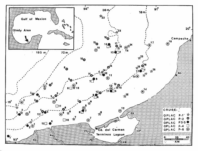 Fig. 1. Campeche Sound off Terminos Lagoon. Principal physiographic and bathymetric characteristics of the area are shown. Also the location of sampling stations of the six research cruise are indicated: Abreviations: RG = Grijalva River, RS San Pedro River, PA = Pom-Atasta, PE = Palizada del Este, CHB = Chumpán-Balchacah, PE = Palizada del Este, CHB = Chumpán-Balchacah, PE = Palizada del Este, CHB = Chumpán-Balchacah, Sabancuy and RO = Champotón River. METHODS
ENVIRONMENTAL PARAMETERSA global analysis of the region's environmental dynamics has been realized based on a total of 15 environmental parameters (see Tables 1 to 5 and discussion). Four parameters out of these: Salinity, transparency, substrate type and bahtymetry are considered to be important in the distribution and abundance of fish populations. Mean water transparency has been estimated by relating it with depth according to the followino- formula, based upon Secchi's, disk: T= σ(t/p 100)/N in which T = percentage of transparency; t = transparency during a sampling; p = depth during this sampling, and N = total number of events of t/p. ECOLOGICAL SIMILARITYWith the aim to know the ecological affinity gradient between the different sampling stations, a computer program was developed to do cluster analysis (Davies, 1971; Sneath and Sokal, 1972). Cluster analysis in its simple matching modality (Davies, 1971) was used for the treatment of the different environmental characteristics. In this way we obtained a similarity index close to 1 and formed stations of the first group; remaining stations were reassembled at minor similarity levels. This procedure was repeated at steps of 0.0 1 and each time larger groups with less similarity were found. Once the last group was formed, all stations had been assembled. Results are presented in dendrograms of stations versus environmental parameters (see Discussion). 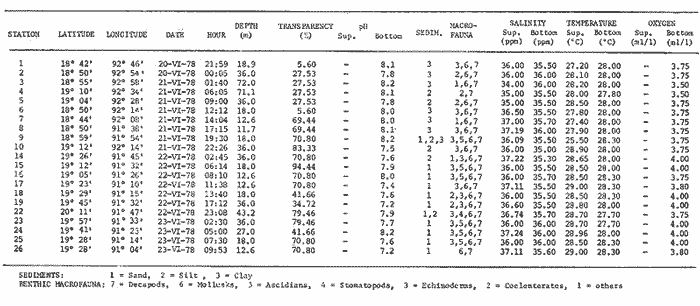 Table 1 OPPLAC/P-1 CRUISE, SAMPLING STATIONS OF THE STUDY AREA. ENVIROMENTAL PARAMETERS AND CHARACTERIZATION OF THE HABITAT 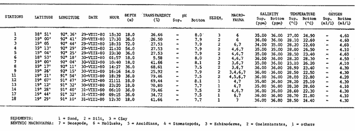 TABLA 2 OPLAC/P-2 CRUISE STATIONS OF THE STUDY AREA ENVIROMENTAL PARAMETERS AND CHARACTERIZATION OF THE HABITAT This kind of analysis, modified, was utilized by Horn. and Allen (1976), Warburton (1978), Chávez (1979), Daniels (1979), Yáñez-Arancibia et al. (1980), Sánchez-Gil et al. (1981), and Vargas Maldonado et al. (1981) for subsystem, or habitat delimitation based upon ecological affinity of fish populations and correlation with environmental parameters. 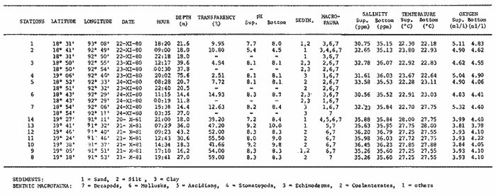 Table 3 OPLAC/P-3-5 CRUISE, SAMPLING STATIONS OF THE STUDY AREA, ENVIROMENTAL PARAMETRS AND CHAREACTERIZATION OF THE HABITAT. 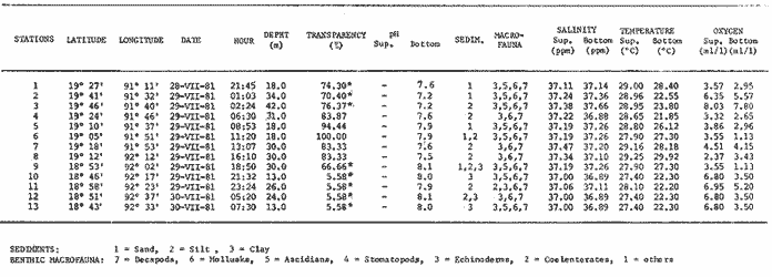 TABLE 4 OPLAC/P-4 CRUISE SAMPLING STATIONS OF THE STUDY AREA, ENVIROMENTAL PARAMETERS AND CHARATERIZATION OF THE HABITAT. RESULTS
OPLAC/P- 1 CRUISEThe region's environmental analysis for june 1978 corresponds to the beginning of the rainy season. It showed an almost homogeneous salinity and temperature pattern, values oscillating between 35 to 36 ppt and 27.7 to 28.3°C, respectively. Differences which delimit the presence of two subsystems occur, however, defined by the corresponding special environmental dynamics. In Zone A highest values of pH (7.8 to 8.2) were found, as well as lowest ones of dissolved oxygen (3.5 to 3.7 ml/l) and a high organic content (> 10%). In Zone. B those parameters were inverted, the lowest pH values (7.2 to 8.2), the highest of dissolved oxygen (3.7 to 4 ml/l) and a low organic content (3%). Those environmental differences are stressed by other habitat parameters for instance, by the composition and texture of the sediments: sediments are clayish in Zone A and sandy in Zone B(Table 1). We noted a high affinity between the sampling stations of each group, with significant value of ecological similarity (0.96) that shows a highly homogeneous environment (Fig. 2). Quantification of this ecological affinity allows to establish a transition points or boundary of variable limits in-between Zones A, and B; this transition area goes from the Terminos Lagoon in a northward direction. 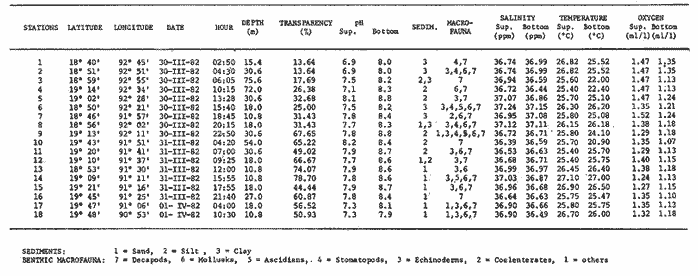 TABLE 5 P´LAC/P-6 CRUISE, SAMPLING STATIONS OF THE STUDY AREA, ENVIROMENTAL PARAMETERS AND CHARATERIZATION OF THE HABITAT. OPLAC/P-2 CRUISEThe environmental analysis of the area during August 1980 corresponds to the rainy season too. Again, an almost uniform pattern regarding salinity 34 to 36 ppt, temperature 23 to 28°C, and pH 7.5 to 8.1 was recorded, and again we distinguished two zones (A and B). In Zone A highest values of dissolved oxygen were found (4.1 to 4.6 ml/l) while those values stood opposite in Zone B (4.1 to 4.3 ml/l) (Table 2). Quantification of ecological affinity shows differences in the station assembly of each habitat. Zone A presented low values of ecological similarity (0.66 to 0.71) which means that this is a heterogeneous área; Zone B showed higher values (0.77), revealing a higher stability (Fig. 3). The zone of variable boundaries showed up once more off Terminos Lagoon but with a northeast orientation, separating Zone A, which is highly influenced by the adjacent estuarine systems, from Zone B. OPLAC/P-3-5 CRUISEIntegrating the environmental information on the area corresponds with sampling during the beginning of the stormy wind season ("nortes") (OPLAC/P-3, November 1980 and OPLAC/P-5, October 1981, Fig. 4). The two environmental zones or subsystems already defined and characterized appeared once again. In Zone A broad ranges of salinity and temperature 32 to 36 ppt and 22.5 to 28.0°C were found respectively, as well as the highest values of dissolved oxygen (from 4.6 to 5.3 ml/l) the lowest values of pH (4.5 and 8.7), and transparency (4.5 to 14.9%) associated to the flow of continental waters, which is characteristic of this season. In Zone B, environmental ranges were smaller, i.e., salinity of 35 to 36 ppt, temperature of 27.0 to 28.0°C, lowest values of dissolved oxygen (3.8 to 4.4 ml/l), highest values of pH (7.2 and 9.3) and tranparency (39.2 to 59.0%), the latter associated with a small flow of continental waters; this zone is typically a marine area (Table 3). 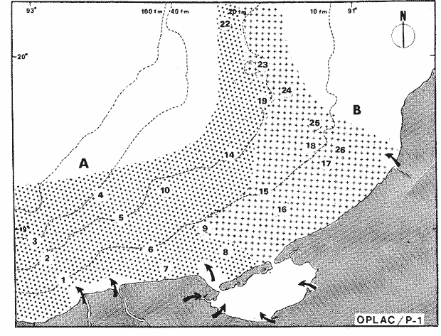 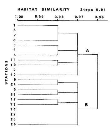 Fig. 2. The map shows the distribution of two habitats or ecological subsystems (A and B) in Campeche Sound; this map, is based on the characteristics of environmental parameters found during OPLAC/P-1 Cruise (summer 1978). Arrows indicate the flowof epicontinental waters towars the literal zone. The graph corresponeds to the dendrogram of ecological similanity for the evironmental parameters of the in this season. 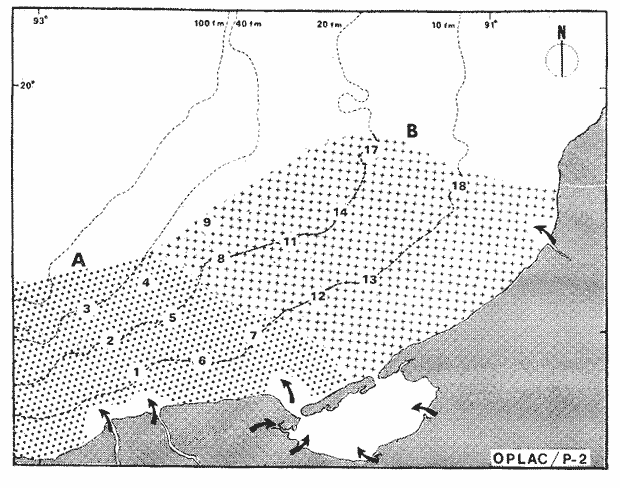 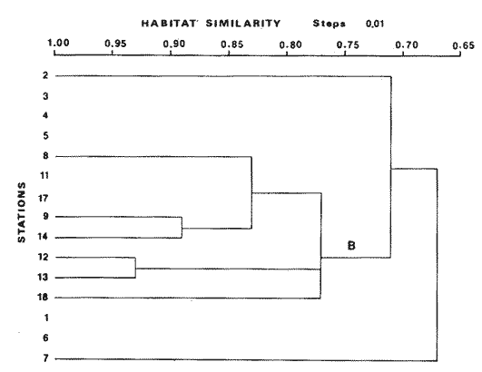 Fig. 3. The map shows the distribution of two habitats or ecological subsystems (A and B) in Campeche Sound; this map is basedon the characteristics of environmental parameters found during OPLAC/P-2 Cruise (summer 1980). Arrows, indicate the flow of epicontinental waters toward the littoral zone. The graph corresponds to the dendrogram of ecological similarity for the environmental parametersof the parameters of the area in this season. 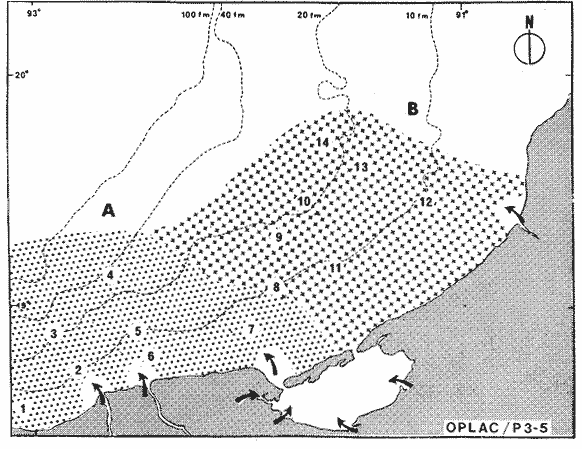 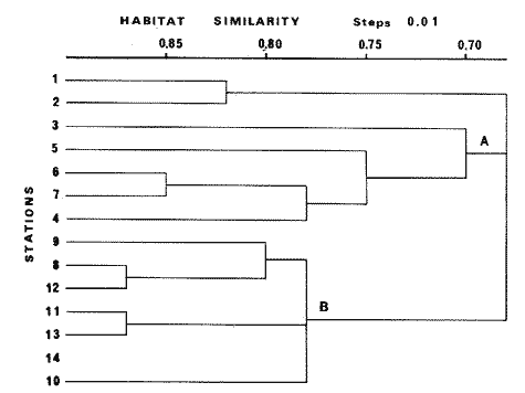 Fig. 4. The map shows the distribution of two habitats or ecological subsystems (A and B) in Campeche Sound; this map is based on the characteristics of environmental parameters found during OPLAC/P 3-5 . Arrows indicate the flow of epicontinental waters toward the littoral zone. The graph corresponds to the den drogram of ecological similarity for the environ mental parameters of the arca in this season. It is shown in figure 4 that the area which comprises Zone A presents a broad range of ecological similarity (from 0.70 to 0.85), with intern assemblies that allow us to establish the prevailing environmental heterogeneity. On the other hand, the arca which comprises Zone B has an even higher environmental similarity that allow us to characterize it as a more homogeneous arca. The zone of variable boundaries showed up off Términos Lagoon with a northeastern orientation. OPLAC/P-4 CRUISEThe environmental analysis of the arca in July 1981 was done during the rainy season It shows slight environmental variations with respect to the same season sampling. Althougt we could not distinguish the two zones de scribed as Zone A and B, particular charac teristics could be observed in both areas. The arca close to the coastline exhibited and irregular distribution of the different environmental parameters such as: salinity (from 36.8 to 37.2 ppt) , temperature (from 22.3 to 28.1°C), low concentrations of dissolved oxyger (from 2.65 to 3.50 ml/l), medium values of pH (7.2 to 8.0) and transparency (5.6 to 83.4%). This zone showed lowest values o ecological similiarity (0.72), which indicated i is a heterogeneous environment due to its circu lation pattern and the discharge of rivers, whic is characteristic of this season (Table 4, Fig. 5) Towards the arca furthest from the coast, more uniform salinity pattern was found (36.1 to 37.6 ppt) , temperature ranging (fron 22.3 to 28.90C) , high concentrations of dissolve oxygen (5.2 to 8.0 ml/l), medium values o pH (7.2 to 8.1) and lowest transparency (from 5.5 to 76.4%) ; furthermore a higher ecologica similarity was found (0.81) (Table 4, Fig. 5) Finally, a well defined central transition zone showed up, characterized by the most uniform. salinity values (37.1 to 37.4 ppt) , temperature varying only slight1y (from 27.3 to 29.1°C), medium values of dissolved oxygen (from 2.3 to 4.5) and highest pH (7.5 to 7.9) , and transparency values (from 83.3 to 100%,). This small central arca showed the highest values of ecological similarity (0.96), standing out as a dense and only slight1y heterogeneous zone (Table 4, Fig. 5). OPLAC/P-6 CRUISEThe environmental analysis of the arca in March 1982, during the beginning of the dry season, showed again those habitats called Zones A and B. During this season both zones tend to homogeneity, presenting most uniform salinity values from 36 to 37.2 ppt, a temperature of 20 to 27.0°C, and dissolved oxygen at values of 1.0 to 1.4 ml/l; with respect to other environmental parameters, however, differences showed up. At Zone A high values of pH (8.0 to 8.8) were recorded, as well as the lowest transparency values (13.6 to 67.6%). At Zone B we registered low pH values (7.2 to 8.7) and the highest transparency (from 44.4 to 78.7%). The similarity of the two, station groups, revealed a very similar ecological affinity (0.76) which would confirm its homogeneity (Table 5, Fig. 6). The boundary of variable limits showed up with a slant towards the gradient and is delimited by stations 5, 6, 8, and 9 as a central transition zone. The latter show major affinity with Zone B; this is quantified in the dendrogram of respective ecological affinity (Fig. 6). ConclusionesDISCUSSION AND CONCLUSIONSThe environmental characteristics with the most significant implication for the continental shelf of Campeche (adjacent to Terminos Lagoon) depend on littoral circulation and on the discharge of Grijalva and San Pedro rivers at the occidental tip, and on the flow of Champoton river to the east. While the central arca depends principally on the discharge of Terminos Lagoon through Boca del Carmen. Very special caracteristics correspond to the zone under study due to the exchange of oceanic and coastal waters and the transition from terrigenous materials to calcareous sediments; variations are being regulated by the local meteorology, climatology, and oceanography. 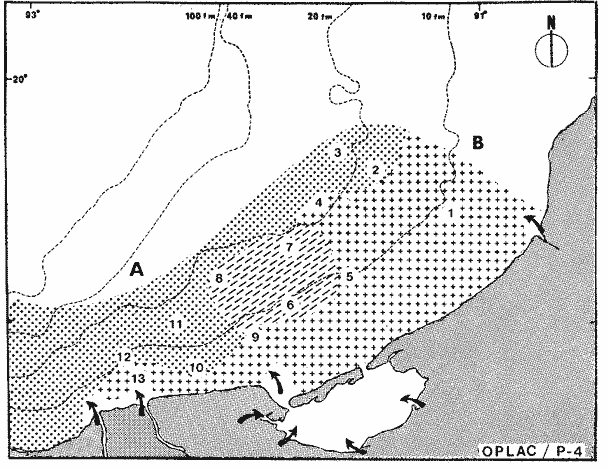 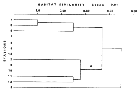 Fig. 5. The map shows the distribution of environmental characteristics of the ecological system of Campeche Sound during OPLAC/P-4 Cruise (summer, 1981) . The presence of a well defined central transition zone is highlighted Arrows indicate the flow of epicontinental waters toward the littoral zone. The graph corresponds to the dendrogram of ecological similarity for the environmental parameters of the area in this season. 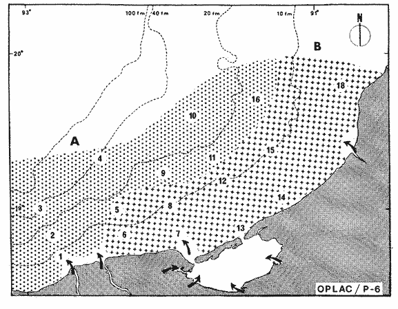 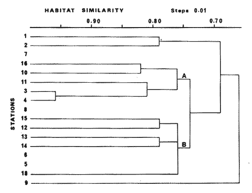 Fig. 6. The map shows the distribution of two habitats or ecological subsystems (A and B) in Campeche Sound; this map is based on the characteristics of environmental parameters found during OPLACIP-6 Cruise (spring, 1982). Arrows indicated the flow of epicontinenetal waterstoward the litoral zone. The grapht corresponds to the dendrogram of ecological similarity for the environmental parameters of the area in this season The dominant climate is Amw, hot subhumid with rain in summer (from May to September) (García 1973), mean annual temperature ranges above WC and mean precipitation oscillates between 1 100 and 2 000 mm; winds blow predominantly in a E-SE direction during March-April and until August-September, changing to a NNE direction during October until February (Fig. 7). There is a broad continental shelf which modifies with depth, but the general superficial shape is convex; the analysis of sediments indicates that the principal flow is provided by the fluvial systems of Grijalva-Usumacinta rivers and the carbonated shelf of Yucatan. The organic material content is more abundant in the silty-clay zone, due to the fluvial and estuarine flow present there; the CaCO3 percentage, however, has a direct relation with the thicker sediment layer (Fig. 8). The dynamics of neritic waters contributes to the complexity of this area; hydrological characteristics stand out because of the flow of epicontinental and estuarine waters, which are characteristic of the coastal zone. Mancilla and Vargas (1980) and Graham et al. (1981) showed that through Carmen Inlet, a genuine net flow of Terminos Lagoon towards the adjacent continental shelf is produced; and Emilsson (1976) found that during summer littoral currents have a northwestward direction with speed of 6 cm sec-¹. Generrally, current speed in the Gulf of Mexico does not very significantly; it shows the value of 0.7 knots between winter and fall, and the value of 0.6 knots between summer and spring (Secretaria de Marina, 1974). The examination of correlation matrices an the cluster analysis that conjugated habitat delimitation (Tables 1 to 5, Figs. 2 to 6) indicates that the ecosystem shows and ecological affinity in two homogeneous regions, called Zone A and Zone B. Dendrograms of ecological similarity delimit and quantify both subsystems; the graphh measures and establishes the ecological similarity between the sampling stations. Finally, maps complete the spatial illustration of the habitats. The analysis leads us to present the following model for the ecological subsystems (habitats) in Campeche Sound(Fig. 9). Figure 8 characterizes the differences between Zone A and B; sedimentry provinces are correlated positively with those zones (Fig. 9). Physical interactions between Campeche Sound and Términos Lagoon are manifested and a terrigenous delta could be characterized, immersed at the exit of Carmen Inlet (west inlet), as a sedimentary environment influenced by the fluvial-deltaic system associated with the area. Another delta (calcareous) was localized towards the entrance of Puerto Real Inlet (east inlet ), being a sedimentary environment influenced by littoral currents with their marine effect (Yáñez-Arancibia and Day, 1982; Yáñez-Arancibia et al., 1983). 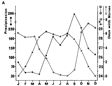 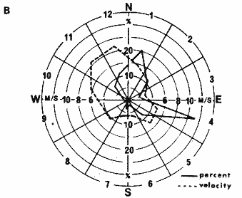 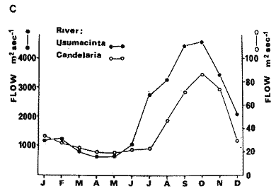 Fig. 7. Relationship of the Principal climatic features of Campeche Sound and adjacent areas. A) Temporal variation of environmental temperature, "nortes", winds, and precipitation. B) Direction and speed of winds, and C) Discharge of Candelaria and Usumacinta Rivers m³sec-¹. 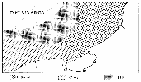 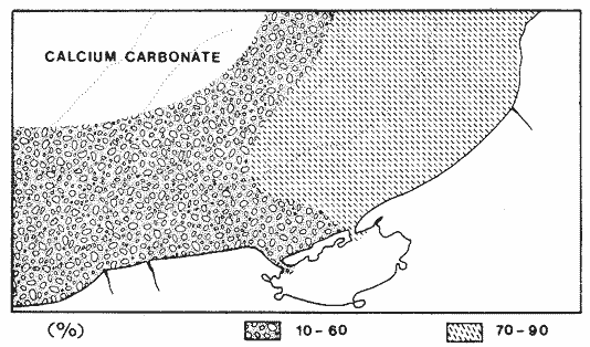 Fig. 8. Map showing distribution of the different types of sediments in Campeche Sound. Zone A, clay and terrigenous silts; Zone B, calcareous sands. Percentage distribution of CaCO3 in both habitats (Zones A and B).
The transition area or boundary of variable limits between both subsystems oscillates seasonally (Fig. 2 to 6), depending on the meteorological phenomena (Fig. 7) and the seasonal pattern of coastal circulation (Emilsson, 1976). 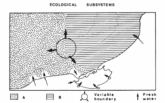 Fig. 9. Conceptual diagram showing the two habitats or ecological subsystems in Campeche Sound (Zones A and B), which were delimited based on the following environmental characteristics: Bathymetry, temperature, salinity, dissolved, oxygen, transparency, pH texture and nature of sediments, macrobenthic fauna and vegetation. Campeche Sound is in front of the most important river discharge in the Southern Gulf of Mexico, a shore line domined by marshes, mangroves and a number of lagoon-estuarine environment. Aspects of these river-ocean interactions are conspicuously evident in the Mississippi Sound (Turner 1982). In the Southern Gulf of Mexico the fresh water imput is the highest in North America after the Mississippi River, and we found similar patterns discussed in different papers edited by Turner (1982). Vertical stratification of the water column near the rivers mouth lead to the isolation of water masses and reduced mixing. Horizontal fresh water diffusion varies with changes in meteorological forcing function, which result in distinctive biological communities and dilution rates. Rivers sediment transport, as well as the lack of transport affects community com position and metabolism and also subsur-face water characteristics. The location of the fresh water-sediment plume may change, but it is hoped that the basic physical phenomena taking place within it are coupled in time and space and are therefore always observable. Finally, from the analysis of more than 1000 environmental parameters measurements obtained in Campeche Sound between 1978 and 1982, we can conclude that: 1) Three climaticmeteorologic periods occur: a) dry season from February to May; b) rainy season from June to October, and c) "nortes" season from November to February 2) A high gradient of silty-clay-sandy sediments exists with CaCO3 content ranging from 10 to 90% which in turn is related to water transparency that varies from 5 to 100%. 3) A moderate alinity pulse exists oscilling from 33 ppt (when the "nortes" season start) to 38 ppt (at the beginning of the rainy season); temperature varies during these climatic periods from 22° C to 30° C. 4) Two habitats (ecological subsystems) can be delimited: a) Zone A with an estuarine influence, and b) Zone B, typically marine environnient. 5) The water quality at Campeche Sound is maintained through the hydrological processes of the southern Gulf of Mexico and the fluvial discharge. AgradecimientosACKNOWLEDGEMENTSThe institutional and financial support for the present study was provided by the Instituto de Ciencias del Mar y Limnología, Universidad Nacional Autónoma de México (1CMLUNAM), and Secretaría de Marina, Secretaría de Pesca y Petróleos Mexicanos (PEMEX) through the Programa Coordinado de Estudios Ecológicos de la Sonda de Campeche (PCEESC). The support was also provided by the UNAM-CONACYT Project PCMABEU 005322. The logistic support was provided by Naviera REX, S. A., with "La Nueva Ley de Pesca" fish vessel (OPLAC/P-1 and OPLAC/ P-2 cruises), Secretaria de Marina with "Dragaminas-20" oceanographic vessel (OPLAC/P-3 cruise) and Secretaría de Educación Pública with "Marsep-l" training ship (OPLAC/P-4, OPLAC/P-5 and OPLAC/P-6 cruises). The authors thank Sergio Licea Durán for complementary field information to recording lata. To the Laboratorio de Ictiología y Ecologia Estuarina. (ICML) team for encouragement, information obtaining and field support: Hernán Álvarez, Margarito Tapia, Felipe Amezcua, Domingo Flores and Arturo Aguirre. For statistical analysis of data, preparation of tables, figures and general discussion we want knowledge to Margarito Tapia, Ma. de la C. García and Ana Laura Lara-Domínguez. LITERATURABESSONOV, N., O. GONZÁLEZ and A. ELIZAROV Resultado de las investigaciones Cubano-Soviéticas en el Banco de Campeche. Coloquio sobre Investigaciones y Recursos del Mar Caribe y Regiones Adyacentes. UNESCO/FAO 1974 317-323 BOUMA, A. H. Contribution on the Physical Oceanography of the Gulf of Mexico. Distribution of sediments and sedimentary structure in the Gulf of Mexico. Capurro, L.R.A. and L. Reid Texas A & M University Oceanographic Studies, Gulf Publishing Co. Houston, Texas 1972 35-65 3 CAPURRO, L. A. La circulación oceánica en el Golfo de México. Carranza J. Mem. IV Congr. Nal. Ocean. México 1972 3-12 CHÁVEZ, E. A. Análisis de la comunidad de una laguna costera de la costa sur occidental de México. An. Centro, Cienc. del Mar y Limnol. Univ. Nal. Autón. México 1979 15-44 6 (2) CRUZ DE LA, A. Coloquio sobre Investigaciones y Recursos del Mar Caribe y Regiones Adyacentes. Estudios de plancton en el Banco de Campeche. UNESCO/FAO 1971 375-383 DANIELS, K. Proc. Third Coastal Marsh and Estuary Management Symposium. Habitat designation based on cluster analysis of Ichthyofauna. Day Jr., J. W., D. D. Culley, R. E. Turner y A. J. Murphrey Louisiana State University Division of Counting Education, Baton Rouge, La. 1979 317-324 DARNELL, R. M. and T. M. SONIAT Ecological Processes in Coastal and Marine Systems. The estuary continental shelf as an interactive system. Robert J. Livingston Marine Science. Plenum Press New York. 1979 489-525 10 DAVIES, R. G. Computer Programming in Quantitative Biology. Academic Press. London 1971 420-430 EMILSSON, I. La oceanografía regional con respecto a los problemas actuales y futuros de la contaminación y de los recursos vivos, Golfo de México. Reunión Internacional de Trabajo COI/PNUMA, Sobre Contaminación Marina en le Caribe y Regiones Adyacentes. 1976 1-24 13-18 Dic. GARCÍA, E. Modificaciones al Sistema de Clasificación Climática de Köppen (para adaptarlo a las condiciones de la República Mexicana). Instituto de Geografía, Univ. Nal. Autón. México 1973 246 p. GRAHAM, D. S., J. P. DANIELS, J. M. HILL and J. W. DAY, Jr. An. Inst. Cienc. del Mar y Limnol. A preliminary model of the circulation of Laguna de Términos, Campeche, México. Univ. Nal. Autón. México 1981 51-62 8 (1) GUTIIRREZ-ESTRADA, M. Tesis M. en C. Sedimentología del área de transición entre las provincias terrígena y carbonatada del suroeste del Golfo de México. Fac. Ciencias, Univ. Nal. Autón. México 1977 175 p. HORN, H. M. and L. G. ALLEN Bull. South Cal. Numbers of species and faunal resemblance of marine fishes in California Bays and estuaries. Acad. Sci. 1976 159-170 75 (2) LANZA DE LA, G., A. RODRÍGUEZ, J. ESTRADA and S. GUEVARA Mem. I. Reunión Latinoamericana sobre Ciencia v Tecnología. de los Océnos. Hidrología de la Bahía de Campeche y norte de Yucatán. Sria. Marina. Veracruz México 1976 108-161 2 26 mayo al 1° junio, 1976 LEIPPER, D. F. Gulf of Mexico: Its Origin, Waters and Marine Life. Physical oceanography of the Gulf of Mexico. Galtsoff, P. S. Fish. Bull. 89 Fish., Wild. Serv. 1954 119-138 55 LICEA-DURÁN, S. Symposium on Program in Marine Research in the Caribbean and Adjacent Regions. Caracas, Venezuela. 12-16 July 1976. Variación estacional del fitoplancton de la Bahía de Campeche, México (1971-1972). Stewart, H. B. Papers on Fisheries Aquaculture and Marine Biology, FAO Fish. Rep. 1977 253-273 200 LICEA-DURÁN, S., R. LUNA, P. TORRES and C. TREJO Informe Final del Proyecto de Investigaciów Evaluación de los Posibles Efectos del Derrame del Pozo IXTOC-I Sobre las Comunidades del Fitoplancton y la Productividad Primaria. PCEESC/ UNAM/ICML (IF) 1982 48 p., 11 tablas, 16 figs. LYNCH, S. A. Gulf of Mexico: Its Origin, Waters and Marine Life. Geology of the Gulf of Mexico. Galtsoff, P. S. Fish. Bull. 89 Wild. Serv. 1954 67-87 55 MANCILLA PERAZA, M. and M. VARGAS FLORES An. Centro Cienc. del Mar y Limnol. Los primeros estudios sobre la circulación y el flujo neto de agua a través de la Laguna de Términos, Campeche. Univ. Nal. Autón. México 1980 1-12 7 (2) MARMER, H. A. Gulf of Mexico: Its Origin, Waters and Marine Life. Tides and sea level in the Gulf of Mexico. Galtsoff, P. S. Fish. Bull. 89 Wild. Serv. 1954 101-103 55 MORTON, W. T., W. L. PERRY and R. S. RUSHTON Historical environmental data, Gulf of Mexico area 18. U. S. Naval Oceanographic Office, Deep Ocean Surveys Division 1967 19 p., 117 figs. NOWLIN, W. D. Jr. Contribution on the Physical Oceanography of the Gulf of Mexico. Winter circulation patterns and property distributions. Capurro L. R. A. and J. L. Reid Texas A & M University Oceanographic Studies, Gulf Publishing Co. Houston, Texas 1972 351 2 PRICE, W. A. Gulf of Mexico: Its Origin, Waters and Marine Life. Shorelines and coasts of the Gulf of Mexico. Galtsoff, P. S. Fish. Bull. 89 Fish. Wild. Serv. 1954 55 39-66 REZAK, R. and G. S. EDWARDS Contributions on the Physical Oceanography of the Gulf of Mexico. Carbonate sediments of the Gulf of Mexico Capurro, L.R.A. and J. L. Reid Texas A & M University Oceanographic Studies, Gulf Publishing. Co. Houston, Texas 1972 263-280 3 SÁNCHEZ-GIL, P., A. YÁÑEZ-ARANCIBIA and F. AMEZCUA LINARES An. Inst. Cienc. del Mar y Limnol. Diversidad, distribución y abundancia de las especies y poblaciones de peces demersales de la Sonda de Campeche (Verano, 1978). Univ. Nal. Autón. México 1981 209-240 8 (1) SANTOYO, H. and M. SIGNORET Rev. Lat. amer. Microbiol, 1973 Hidrología y fitoplancton en un transecto en la plataforma continental de la Bahía de Campeche, México. (Agosto, 1972). 1972 207-215 (15) SNEATH, H. A. P. and R. R. SOKAL Numerical Taxonomy: The Principles and Practice of Numerical Classification. W. H. Freeman and Company San Francisco 1979 573 p. SECRETARíA DE MARINA Atlas Oceanográfico del Golfo y Mar Caribe. (Sección Mareas y Corrientes). 1974 38 P. OSM N° 1000 TABLAS DE PREDICCIÓN DE MAREAS Serv. Mareogr. Nal., 1981 (Puertos del Golfo de México y Mar Caribe). Datos Geofísicos Serie A Oceanografía. Univ. Nal. Autón. México. Inst. de Geofís. 1982 191 p. TURNER, R. E. (coordinator) Oceanography, of the Mississippi River bight. Contr. Mar Sci. 1982 107-1980 (eight papers). 25 VARGAS MALDONADO, I., A. YÁÑEZ-ARANCIBIA and F. AMEZCUA LINARES An. Inst. Cienc. del Mar y Limnol. Ecología y estructura de las comunidades de peces en áreas de Rhizophora mangle y Thalassia. testudinum de la Isla del Carmen, Laguna de Términos, sur del Golfo de México. Univ. Nal. Autón. México 1981 241-266 8 (1) VÁZQUEZ DE LA CERDA, A. M. Proceedings of the CICARII Symposium. Circulación del agua en el suroeste del Golfo de México. Caracas Venezuela 1977 155-171 12-16 de julio de 1976 VILLALOBOS-FIGUEROA, A., M. SIGNORET-POILLON, B. PÉREZ, G. VILLARREAL, S. LICEA, A. VÁZQUEZBOTELLO, R. DE LARA, J. L. CALDERÓN and J. L. ARREDONDO Informe de datos oceanográficos en la Sonda de Campeche en el Crucero COSMA/71-04 B CICAR. Rep. Cienc. Mar 3 (BI). Dir. Gral. de Oceanogr. y Señal. Mar Depto. Cienc. Mar-Inst. Biol. Secretaría de Marina, Univ. Nal. Autón. México, 1972. 1972 VILLALOBOS, A. and M. E. ZAMORA Mem. I. Simp. Lat. amer. Importancia biológica de la Bahía de Campeche. Oceanogr. Biol. (México) 1975 375-394 Nov. 25-29, 1974 VILLALOBOS, A. and M. E. ZAMORA Mem. II. Simp. Lat. amer. Importancia biológica de la Bahía de Campeche y de la Península de Yucatán (Segunda Parte). Oceanogr. Biol. Cumaná, Venezuela, . Publ. Univ. Oriente 1977 79-117 Nov. 24-28, 1975 WALNE, P. R. The importance of estuaries to commercial fisheries. I. Barnes R. S. K. and J. Green The Estuarine Environment Applied Science Publishers Ltd. London 1972 107-118 WARBURTON, K. Community structure, abundance and diversity of fish in a Mexican coastal lagoon system: Estuar. Coast. mar. Sci. 1978 497-519 7 YAREZ-ARANCIBIA, A. and J. W. DAY, Jr. Coastal Lagoons. Ecological characterization of Terminos Lagoon a tropical lagoon-estuarine system in the Southern Gulf of Mexico. Lasserre, P. and H. Postma Oceanológica Acta. 1982 431-440 Vol., Spec. 5 (4) YAREZ-ARANCIBIA, A., F. AMEZCUA LINARES and J. W. DAY, Jr. Estuarine Perspectives. Fish community structure and function in Terminos Lagoon, a tropical estuary in Southern Gulf of Mexico. Kennedy V. Academic Press Inc. New York 1980 465-482 YAREZ-ARANCIBIA, A., A. L. LARA-DOMÍNGUEZ, P. CHAVANCE and D. FLORES HERNÁNDEZ An. Inst. Cienc. del Mar y Limnol. Environmental behavior of Terminos Lagoon ecological system, Campeche, Mexico. Univ. Nal. Autón. México 1983 137-176 10 (1) YAÑEZ-ARANCIBIA, A., P. SÁNCHEZ-GIL, M. TAPIA GARCÍA and MA. DIE LA C. GARCÍA-ABAD Proceedings of the joint Oceanographic Assembly 1982. General Symposia. Ecology and community structure of demersal fish in Campeche Sound in the Southern Gulf of Mexico: Ocean. Tropical Resources. CNC/SCOR. Canadian National CommitteeScientific Committee on Oceanic Research Ottawa, Ont. 1982a 189 p., microphilm, 3:107. YAÑEZ-ARANCIBIA, A., A. L. LARA-DOMÍNGUEZ, P. SÁCHEZ-GIL, I. VARGAS MALDONADO, MA. DE LA C. GARCÍA-ABAD, H. ÁLVAREZ GUILLÉN, M. TAPIA GARCÍA, D. FLORES HERNÁNDEZ and F. AMEZCUA LINARES Ecology and evaluation of fish community in the Campeche Sound and Terminos Lagoon: Estuaryshelf interactions in the Southern Gulf of Mexico. International Symposium on Utilization of Coastal Ecosystem: Planning Pollution and Productivity. Atlántica Rio Grande 1982b 130 5 (2) ZETLER, B. D. and D. V. HANSEN Contributions on the Physical Oceanography of the Gulf of Mexico. Tides in the Gulf of Mexico. Capurro, L. R. A. and J. L. Reid Texas A & M University Oceanographic Studies, Gulf Publishing Co. Houston, Texas 1972 265-275 2
|