|
A PRELIMINARY MODEL
OF THE CIRCULATION OF LAGUNA DE TÉRMINOS, CAMPECHE, MÉXICO
Trabajo recibido el 15 de enero de 1981 y aceptado para su publicación
el 4 de mayo de 1981.
DONALD STEVEN GRAHAM Tudor Engineering Company, San Francisco, California, USA, 94105.
JOHN PAUL DANIELS 8013 SW 102 Avenue, Gainesville, Florida, USA, 32601.
JOHN M. HILL Dept. Civil Engineering, Louisiana State University, Baton Rouge, Louisiana, USA, 70803.
JOHN W. DAY, JR. Coastal Ecology Laboratory, Center for Wetland Resources, Louisiana State University, Batton Rouge, Louisiana, USA, 70803.
Se realizó un estudio
preliminar de la circulación en el sistema lagunar-estuarino de la
Laguna de Términos, Campeche, México, utilizando el modelo
numérico CAFE-1 a base de elementos limitados de una fila, de promedio
vertical y de "tiempo real", que calcula los caudales inestables en zonas
costeras poco profundas. Los resultados se comparan con los estudios previos de
Mancilla y Vargas y con dos imágenes históricas de un
satélite de tierra (Landsat). Por otra parte, los resultados del modelo
no han sido verificados y se presentan aquí como datos para 1) ayudar en
el aprovechamiento de recursos costeros locales, 2) proporcionar
información preliminar para la planificación de estudios
posteriores, y 3) demostrar la aplicabilidad de la metodología de
CAFE-1-Satélite de tierra para estudios en el Golfo de
México.
Los resultados del modelo indican que la
Laguna de Términos opera principalmente a base de vientos. Caudales
netos en dirección occidental ocurren casi todo el año debido a
los vientos alisios, pero pueden ocurrir cambios espectaculares de
dirección durante el invierno debido a los vientos "Nortes". Durante
periodos sin viento, la Laguna de Términos tiende a estancarse. Estas
conclusiones están de acuerdo con los datos disponibles del campo y del
satélite. La clave para la mantención de la calidad del agua en
la Laguna, a través de la mantención de caudales netos por
operación del viento, es mantener la capacidad hidráulica de la
boca de Puerto Real.
A preliminary
study of the circulation of Laguna de Términos estuarine system,
Campeche, México, was conducted with the "realtime", vertically
averaged, one-layer, finiteelement CAFE-1 numerical model, which calculates
unsteady flows in shallow coastal arcas. The results are compared with the
previous field studies of Mancilla and Vargas, and with two historic Landsat
satellite images. Otherwise, the model results are unverified and are presented
here: 1) as timely data to assist in the management of local coastal resources,
2) to provide preliminary information for the planning of subsequent studies,
and 3) to demonstrate the applicability of the CAFE-1-Landast methodology for
Gulf of Mexico estuaries.
The model results indicate that
the Laguna de Términos is primarily wind-driven. Trade winds cause net
westward flows to occur most of the year, but spectacular reversals may be
caused in winter by so-called "Norte" winds. During windless conditions, the
Laguna de Términos is surmised to be stagnant; conclusions that
correspond with both satellite and available field data. The key to
water-quality in the Laguna, through maintenance of the wind-driven net flows,
appears to be the hydraulic competence of Puerto Real Inlet.
Laguna de Términos is a large, shallow, coastal lagoon at the base of the Yucatan Peninsula (Fig. I). Petroleum exploration and development in the region have increased the need for environmental and hydraulic information to protect marine resources. In order to complement ongoing ecological studies. (Yáñez-Arancibia and Day 1981); a limited estuary-circulation modelling effort was undertaken in which the real-time numerical finite-element coastal circulation model, "CAFE-I", was applied to Laguna de Términos. It was not possible to collect adequate field data to calibrate and verify the model, so several cases of interest were simulated with speculative, but reasonable, coefficient values and boundary conditions. The results are then compared with available field data and Landsat images. While these results and conclusions are therefore somewhat conjectural, we consider them plausible and possibly useful for many pressing, practical management needs. Also, they may be helpful in assessing incremental data requirenients and for planning future oceanographic field programs. To our knowledge, no comparable modelling effort has been attempted for Laguna de Términos. The scope was limited to the definition of large-scale circulation responses to wind and tidal forcing. 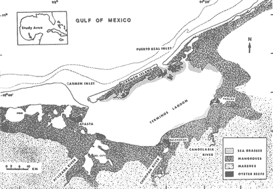 Fig. 1 locatión map of the study area, Laguna de términos After Yañez-Arancibia et. al. (1980). THE CAFE-1 MODELThe CAFE-1 model is a "real-time", vertically-averaged, one-layer, finite-element numerical technique for calculating unsteady flows in shallow coastal seas. It was developed at the Massachusetts Institute of Technology, U. S. A. (Wang and Connor 1975; Connor and Wang 1973), and has been applied to several other estuaries and coastal seas including Apalachicola Bay, Florida, U.S.A. (Graham, Daniels, and Christensen 1979; Graham 1980; Daniels and Graham 1981); Biscayne Bay, Florida, U.S.A. (Swakon and Wang 1977) Massachusetts Bay, Massachusetts, U.S.A. (Connor and Wang 1973); and Moreton Bay, Australia (Steele et al. 1979) among others. The version of the model used in this study was partially developed at the University of Florida, Florida, U.S.A. (Graham, Daniels, and Christensen 1979). THE EQUATIONS OF MOTIONThe equations of motion are developed on a coordinate system with x, y horizontal and z vertical upwards from the bottom. Velocities u and v and unit discharges qx and qy correspond to the x and y directions, respectively. Since the equations of motion are vertically-averaged, there is no velocity in the vertical z-direction. The equations of motion are: 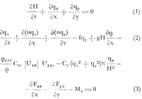 A similar momentum equation exists in the y direction. Where 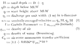 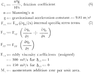 The solution procedure for equations (1) to (9) can be found in Wang and Connor (1975). Briefly, equations (2) and (3) (the hydrodynamics) are solved by the model CAFE-1, which requires boundary and initial conditions to be specified. At each timestep of 60 seconds, for qx, qy, and height above mean low water (MLW), LETRA LATIN η, are output and stored on a computer disc. The model is called "real-time" because the timestep is much smaller than the tidal period, so that the model "tracks" the flows during the tidal period. As seen in equation (2), both convective accelerations and (apparent) eddy viscosity terms are retained in the model. The Boussinesq approximation is employed, and salinity-driven baroclinic effects are ignored. THE GRIDThe finite-element grid used to approximate the geometry of Laguna de Términos is depicted in Figure 2. This grid, which had previously been compiled at Louisiana State University, had to be used in order to minimize costs. This grid has 206 elements, which are labeled in figure 2, and 126 nodes, which are not. It could be described as irregular and coarse. The two ocean boundaries (Carmen Inlet on the west and Puerto Real Inlet on the east) are in lighter tones on all the figures. This grid is prone to instability and provides poor resolution of river inflow effects. It is adequate for large-scale circulation modelling, however, providing the eddy viscosity coefficients are large enough to suppress instabilities. The grid is adequate for the limited purpose at hand, but a new one should be used for future work requiring greater detail or dispersion modelling. THE BOUNDARY CONDITIONSAfter a few tidal cycles the solutions of the equations of motion depend entirely upon the boundary conditions. These include geometry, wind, tides, and, to a far lesser extent, rivers. Ideally, measured data should be used, when these are not available, "reasonable" values are then employed. TIDAL BOUNDARY CONDITIONSTidal boundary conditions were estimated from an analysis of the National Ocean Survey (NOS) Tide Tables (1979). Daily tidal data are provided for Tampico Harbour. Subsidiary station data are given in the same source for Veracruz, Alvarado, Coatzacoalcos, Ciudad del Carmen, and Progreso. Unfortunately, this is not a very dense gauge network and is insufficient for a nice determination of local variations in the Laguna de Términos area. The Carmen data relative to Tampico are summarized:  Also, at Carmen  Hence, there is little difference between the Tampico and Carmen tides, except for phase. The tide at Tampico Harbour is predominantly diurnal with a mild 15-day cycle superposed (NOS Tide Tables 1979; Graham and Daniels 1980). A tide based on the mean diurnal range during the two-week tidal cycle was selected as the prototype. It has a mean range of 1.5 ft = 0.457 m and a period of 24.5 h or 88200 s. Using NOS correction factors to transfer this tide to C. del Carmen, the prototype tide at C. del Carmen then is 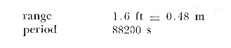 It is suspected that a net westward flow usually exists in Laguna de Términos. This hypothesis is based upon data presented by Mancilla and Vargas (1980), and the prominent floodtidal delta at Puerto Real Inlet. This net flow might be caused either by steady trade winds or by a difference in amplitudes and phases at the two inlets, such as occurs at Apalachicola Bay, Florida, U.S.A. (Graham, Daniels, and Christensen 1979). No good data of amplitude and phase differences between the two inlets appear to exist, however. (According to local information these differences are negligible). A rough analysis was made by comparing the average phase differences [(HW + LW)/2] between Progreso and Carmen, and Coatzacoalcos and Carmen from the NOS data. The map distances along the coast between each were used to find the phase differences per unit length of coast, and these were then applied to the distance between the two passes of Terminos. 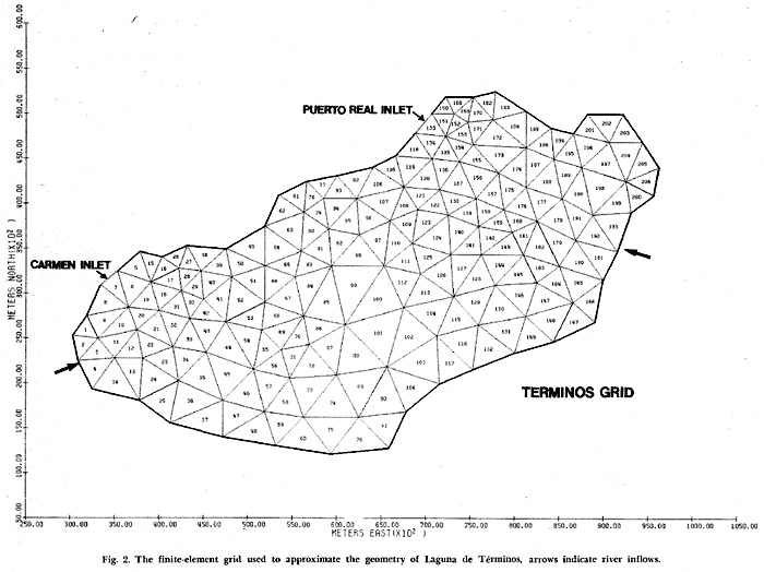 Fig 2. The finite element grid used to aproximate the geometry of laguna de Términos , arrows indicate river inflows. For the Carmen-to-Progreso analysis, a phase difference between Puerto Real and Carmen inlets of 86 s was found. For the Coatzacoalcos Carmen case, a difference (by extrapolation) of 171 s was found. Differences in tidal range along the coast are not great. As a worst case, a simulation was run with the tide at Puerto Real Inlet increased in range to 0.60 m, and the phase at Carmen Inlet lagged by 120 s. This is Case 2, which follows in the section on simulations. RIVER INFLOWSNo readily available information on river inflows could be found. Three major streams drain to the Laguna; the Palizada, the Chumpam, and the Candelaria from west to east, respectively. The average annual inflow of the three to the Laguna is 6 x 10 9 m³ /yr (Yáñez-Arancibia and Day, 1981), of which it is believed that the Palizada contributes approximately 70%, the Chumpam 5%, and the Candelaria 20%.
The CAFE-1 model interprets river inflow discharges as negative unit discharge outflows along a boundary element. The conversion is complicated and involves using local depth as a variable. Briefly, the inflows were set at nodes 2 and 111 (Fig. 2), and depths were set at a practical minimum (for numerical stability) of 0.2 m in the vicinity of these points. River discharge input is correct, but the velocities are not because of the large size of the elements. It was felt that the depth change would adversely affect the model more than the absence of the Chumpam River inflow, so this was not included. River inflow effects were so small that they could be discounted; but, as noted, this is partly due to the grid itself. The river discharges convert to: Q (m³/s) q(m²/s) 133 -.0209 200 -.0134 Palizada 66.5 -.0104 38 -.0047 57 -.0070 Candelaria 19 -.0023 These values represent mean, wet season, and dry season discharges, respectively, based upon a 3:1 ratio of the latter two hypothesized by the fourth author. [] Information supplied to J. W. Day jr. SIMULATIONSFour cases were simulated. There are summarized in table 1 and are: CASE 1For this case the amplitudes are the same at both passes, there is no phase difference in tides, and there is no wind. This represents conditions hypothesized to exist during a windless period. River inflows are 133 m³ /s and 38 m³/s (average annual discharges) flor the Palizada and Candelaria rivers, respectively. 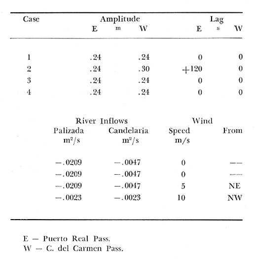 TABLE 1 IMPUT DATA FOR SIMULATIONS OF LAGUNA DE TÉRMINOS HYDRODINAMICS USING THE CAFE-1 MODEL. CASE 2For this case, the tidal range is 0.12 m greater at Puerto Real Inlet than at Carmen Pass, and the phase is lagged 120 s at Carmen Inlet. This is an "outside" worst case of likely tidal variations between the passes which might induce the net westward flow. Other parameters are as in Case 1. CASE 3In this case the conditions are as in Case 1, but a 5 m/s wind is imposed from the NE (45 deg. relative to the x-axis). This is the case wherein steady trade winds are hypothesized to induce the westward net flow. Other conditions are as in Case 1. No wind set-up at the inlets was included in the model. CASE 4This case was intended to observe the likely effects of the Norte wind. A 10 m/s wind from the NE (135 deg. relative to the x-axis) is imposed. Tidal amplitudes and phases are as in Case 1. River flows were set at 19 m³/s. OUTPUT AND FORMATThe timestep for the calculations was 60 s. The tidal period was 88200 s, therefore the calculations were made 88200/60 = 1470 times per tidal cycle. For net velocities, the velocities at each node are added up 1470 times and the results ís plotted (i.e., this is a vector sum andnota mean). The CAFE-1 model produces two unit discharge values and a depth value (i.e., qx, qy), for each node at each timestep. Therefore (2 + 1) * 126 nodes * 1470 timesteps = 555660 pieces of data are produced per tidal cycle for cach case. We have found this to be far too voluminous to be interperted in a printed form. Accordingly, the data were stored on discs, and graphical representations of some aspects of the data were produced (Graham and Daniels 1980). For each run (case) these are: 1) Plots of instantaneous (vertically averaged) velocities for each one-fourth tidal cycle for Cases 1 and 2 as figures 3 and 4, respectively; and for each one-eighth tidal cycle for Cases 3 and 4 as figures 5 and 6, again, respectively. (The length of the scale arrows placed on these figures on the original output corresponded to 0.5 m/s per inch.) 2) Plots of net velocities over a tidal cycle. These are presented for each case as figure 7. (The scale of the arrows on the original output in this case was 0.1 m/s per inch.) 3) Plots of the instantaneous water levels relative to MLW for each one-fourth tidal cycle, which depict the tidal wave amplitude in Laguna de Términos, are presented for each case as figures 8 through 11. 4) Plots showing the movements of four drogues in the Laguna over a period of ten tidal cycles are presented for each case as figure 12. This is another way of showing net movements. (Note that the velocities are vertical ly- averaged, so that a real drogue on the surface would probably act differently from the one depicted if it were not vaned at depth. Similarly, in a stratified estuary, a drogue would be influenced by density currents which are not included in this model.) Finally, the S by each drogue line indicates the starting position of the drogue. BRIEF DISCUSSION OF RESULTS AND COMPARISON WITH HISTORICAL LANDSAT IMAGERYFiguers 3-12 are relatively self-explanatory, so only brief discussions of the results will be made. A tentative verification is attempted by comparing the model output to selected historical Landsat satellite imagery (Band 5; Red Channel, 600 to 700 nm) and information from Mancilla and Vargas (1980). It has been demonstrated in other studies (Graham, Hill, and Christensen 1978; Hill and Graham 1980); Graham and Hill 1980) that enhanced images can be used to corroborate model results, particularly by virtue of their synoptic characteristics. Regarding first the plots of net velocities in figure 7, it can be seen that small to negligible net velocities occur for Case 1. This is also evident in the drogue paths (Fig. 12). The river inflows are apparent for Case 1 in figure 7, as is a small instability near Puerto Real Inlet. Comparing the net flows of Cases 2 and 3, it can be seen that either case can produce the westward flow, although the transverse distribution of velocity is different. Obviously, tidal records should be collected at both passes to determine if Case 2 has any basis in reality. The net flux for Case 4 (Norte wind) is fascinating. The general flow pattern shows the wind set-up in the southeast part of the Laguna forcing the net flux along the barrier island, while producing a local outflow along the southern shore. Field work during a Norte wind would be worthwhile to confirm this pattern. Peak net flows are usually of the order of 0.1 m/s, which it not uncommon (Mancilla and Vargas 1980). Two historic Landsat images are presented which portray gross circulation patterns. Figures 13 and 14 are Band 5 images taken by Landsat 2 on 16 February 1979 and 8 October 1979, respectively. The weather and marine conditions present at the time of these overpasses are unknown, so only a general interpretation is possible. It is surmised that figure 13 was taken during flooding tide during Norte conditions (Case 4), which commonly exist during the winter. Satelite-derived turbidity patterns (which are highlighted in band 5) follow the model generated patterns indicated at 3/8T in figure 6 almost exactly. The circulation close to the island is evident, as are the intrusions along the SW and NE shores, and the two large whirls in the centre of the Laguna. The correspondence with the net velocity for Case 4 in figure 7 is also striking, and this is relevant in that the drogue paths for Case 4 in figure 12 indicate that the timescale of the circulation of the Laguna is of the order of several tidal cycles even under Norte conditions. An ebb tide sequence on a somewhat cloudy October day is depicted in figure 14. From this image the scale of the outlet plume at Puerto Real Pass can be seen, as can its deflection to the west.
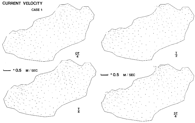 Fig. 3. Plots of instantaneos, vertically-averaged velocity for each one-fourth tidal cycle for Case 1. In all figures fractions of T indicate portion of tidal cycle elapsed. 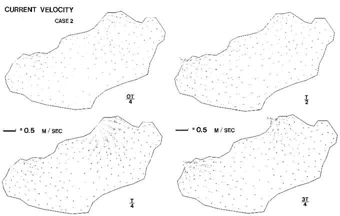 Fig. 4. Plots of instantaneos, vertically-averaged velocity for each one-fourth tidal cycle for Case 2.  Fig. 5. Plots of instantaneous, vertically-averaged velocity for each one-eighth tidal cycle for Case 3. 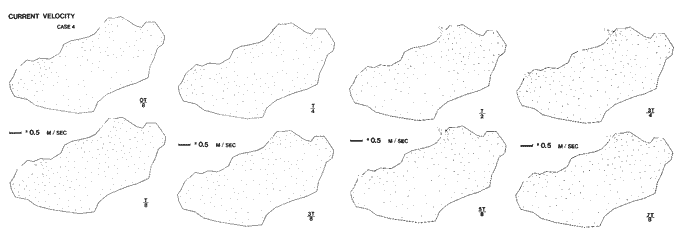 Fig. 6. Plots of instantaneuos, vertically-averaged, velocity for each one-eighth tidal cycle for Case 4. 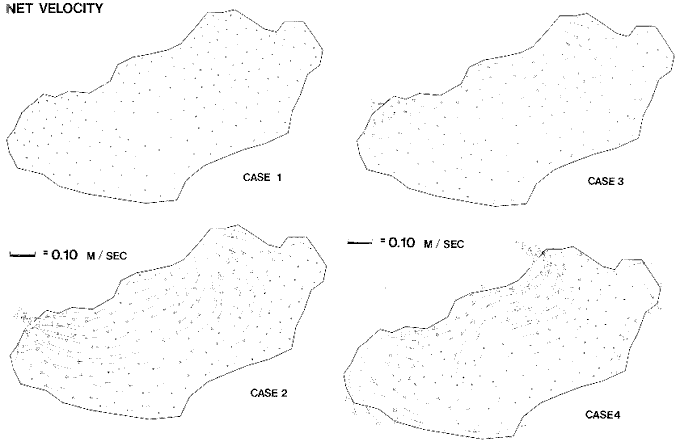 Fig. 7. Net current velocity for each case. 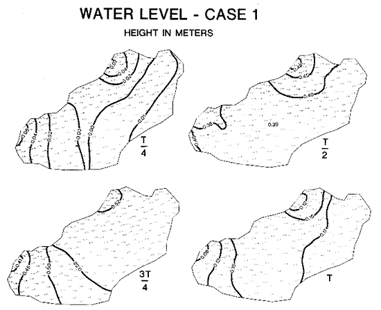 Fig. 8. Water surface levels ralative to MLW for each one-fourth tidal cycle for Case 1. 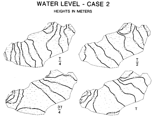 Fig. 9. Water surface levels ralative to MLW for each one-fourth tidal cycle for Case 2. 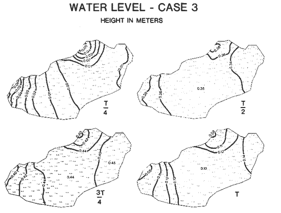 Fig. 10. Water surface levels ralative to MLW for each one-fourth tidal cycle for Case 3. 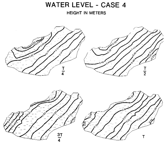 Fig. 11. Water surface levels ralative to MLW for each one-fourth tidal cycle for Case 4. 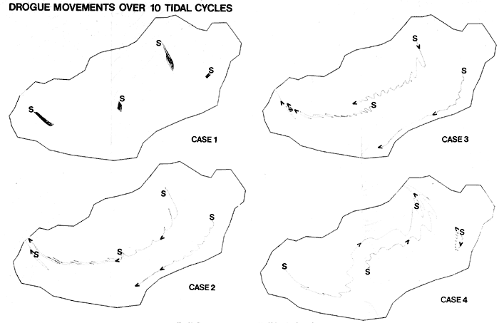 Fig. 12. Drogue movements over 10 tidal cycles for each case. Regarding, the tidal wave plots, figures 8 through 11, it can be seen that the wave entering Carmen Inlet tends to progress faster through the Laguna de Términos, and along the southern shore. Better depth and roughness resolution in the model are needed to confirm this. The nodal location for T/8 of Case 2 (see Graham and Daniels 1980) corresponds rought y with the plot of Mancilla and Vargas (1980) given as figure 2 threin. An argument could be made upon comparison of the tidal waves in Cases 1 and 2, and Mancilla and Vargas' figure, that a phase lag must exist since the Mancilla and Vargas' figure indicates a more rapid eastward wave celerity than does the model. Again, this is worth investigating further insofar as constant bottom roughness was assigned in the model. Better inlet discretization migth be required. [] A methodology for analysis of tidal inlet dynamics with the aid of Landsat images in Apalachicola Bay, Florida, U.S.A. has been developed by Metha and Zeh (1979). SUMMARY AND CONCLUSIONSModels of the probable general circulation of Laguna de Términos, México, for four separate cases of interest have been presented. The results show the tendency of the system to be wind-dominated. Because of the structure of the grid, effects of river flows were not well simulated, but these are expected to be of second or lower order influence upon the hydrodynamics (if not the salinity) in any event. Changes in the hydraulics of either inlet would certainly affect Laguna circulation, and hence water quality. 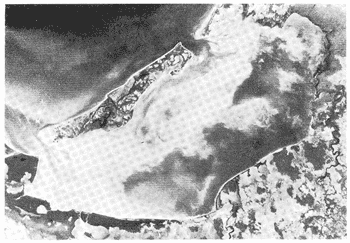 Fig. 13. Landsat 2 image of Laguna de Términos, 16 February 1979 (Band 5). It is probable that a net westward flow exists during the periods with easterly trade winds which persist for much of the year. During periods of light wind there is little net flow (unless the tidal characteristics at each inlet differ) and tidal hydraulics dominate. Net Bay circulation would likely be enhanced (increased) by enlarging Puerto Real Inlet, which appears to be filling. It is, perhaps, kept open now only by outflow during Norte-wind-induced circulation. 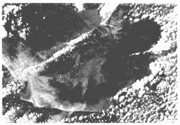 Fig. 14. Landsat 2 image of Laguna de Términos, 8 October 1979 (Band 5). SPECIFIC SUGGESTIONS FOR FURTHER RESARCH1) Detailed comparisons of the tidal wave (and if possible, current) characteristics at the two inlets should be made. 2) In order to calibrate the model, tidal wave heights and velocities in the Laguna should be measured during (a) a windless period, (b) a NE trade wind, and (c) a Norte wind. 3) Data on river inflow characteristics should be compiled and analyzed. 4) A historical review of the stability of Puerto Real Pass should be made. 5) A survey of historical Landsat imagery available for the Laguna de Términos area should be made. 6) A real time study should be conducted where water samples are collected at the time of a satellite overpass. Samples would then be correlated with satellite data and results could be input into the model. AgradecimientosWe thank numerous persons at the Instituto de Ciencias del Mar y Limnología, Universidad Nacional Autónoma de México (1CML-UNAM) for encouragement, information, and critical suggestions. Support for this study was provided by the National Science Fouridation, and the Louisiana Sea Grant College Program maintained by NOAA, U.S. Department of Commerce. Landsat images were provided by the Remote Sensing and Image Processing Laboratory of the Louisiana State University. The Spanish abstract was prepared by Sr. Roberto Iniguez of the Tudor Engineering Company, San Francisco and Dr. Alejandro Yáñez-Arancibia of IMCL-UNAM. This is contribution No. LSU-CEL80-11 of the Coastal Ecology Laboratory, LSU Center for Wetland Resources, Baton Rouge, La. LITERATURACONNOR, J. J. J. D. WANG Mathematical model of the Massachusetts Bay. Massachusetts Institute of Technology Sea Grant Report No. MITSG 4-4, Cambridge, Massachusetts, U.S.A.1973. 210 p. DANIELS, J. P. D. S. GRAHAM Application and calibration of the CAFE-1 model to Apalachicola Bay, Florida. Proc. Fifth Canadian Hydrotechnical Conference. Fredericton, New Brunswick,Canada.1981.515-536. GRAHAM, D. S., Tidal hydrodynamics of Apalachicola Bay, Florida. EOS. Trans. Amer. Geoph. U., 1980.1-272.61 (17): GRAHAM, D. S. J. M. HILL In: Civil Enginerering Applications of Remote Sensing. Field study for Landsat water quality verification. American Society of Civil Engineers Aerospace Division Specialty Conference, Madison, Wisconsin, U.S.A. 1980. 101-117. GRAHAM, D. S. J. M. HILL and B. A. CHRISTENSEN, In: Verification of Mathematical and Physical Models in Hydraulic Engineering. Verification of an estuarine model for Apalachicola Bay, Florida. American Society of Civil Engineers Hydraulics Division Scpecialty Conference, College Park, Maryland, U.S.A.1978.237-245. GRAHAM, D. S. J. P. DANIELS Technical Report, CAFE-1 hydrodynamic simulation of Laguna de Términos, México. Center for Wetland Resources,Louisiana State University, Baton Rouge, Louisiana, U.S.A. 1980.29 p. GRAHAM, D. S., J. P. DANIELS B. A. CHRISTENSEN Proceedings of the American Society of Civil Engineers Specialty Conference, Civil Engineering in the Oceans Predicting circulation changes from bathymetric modification. San Francisco, California, U.S.A. 1979.531-549. IV. HILL, J. M. D. S. GRAHAM. Bulletin de la qualité des eaux, O.M.S., N.U., Utilisation des images accentuées de Landsat pour l´etalonnage des modéles quantitatifs des eaux estuaires en temps réel.20-23.5 (1): MANCILLA, M. M. VARGAS An. Centro Cienc. del Mar y Limnol. Univ. Nal. Autón. México, Los primeros estudios sobre el flujo neto de agua a través de la Laguna de Términos, Campeche. 1980.144.7 (2): MEHTA, A. J. T. A. ZEH In: Conservation and Utilization of Water and Energy Resources. Investigation of the hydrodynamics of inlet plume. American Society of Civil Engineer's Hydraulics/Energy Divisions Specialty Conference, San Francisco, California,U.S.A. 1979. 478-485. NATIONAL OCEAN SURVEY, TIDE TABLES, High and low water predictions. East Coast of North America South America, Including Greenland. National Technical Information Service, PB-286-412. Washington, D.C., U.S.A. 1979. STEELE, J. G., Finite-element modeling of Moreton BAY, Australia. Department of Civil Engineering, the Massachusetts Institute of Technology, Ralph M. Parsons Laboratory Report No. 20, Cambridge, Massachussetts,U.S.A.1977. 62 p. SWAKON, E. A., Jr. J. D. WANG Modeling of tide and wind induced flow in South Biscayne Bay and Card Sound. Univ. of Miami Sea Grant Tech. Bull. University of Miami, Florida, U.S.A. 1977. 1-144. 37: WANG, J. D. J. J. CONNOR Mathematical modeling of nearcoastal circulation. Department of Civil Engineering, the Massachussetts Institute of Technology, Ralph M. Parsons Laboratory Report No. 200, Cambridge, Massachussetts, U.S.A.,1975. 22 p. YÁÑEZ-ARANCIBIA, A. J. W. DAY, JR Ecological characterization of Terminos Lagoon, a tropical lagoon estuarine system in the southern Gulf of Mexico. ISCOL-UNESCO '81, Oceanologica Acta (in press). Bordeaux, France,1981. Sept. 7-14, 1981. YÁÑEZ-ARANCIBIA, A., F. AMEZCUA LINARES J. W. DAY Jr In: Estuarine Perspectives. Fish community structure and function of Terminos Lagoon, a tropical estuary in the southem Gulf of Mexico. Academic Press Inc,: N.Y465-482,1980.
|